|
| Today's walk from The Walker's Guide to the Hambleton Hills |
 |
| The Inn at Hawnby |
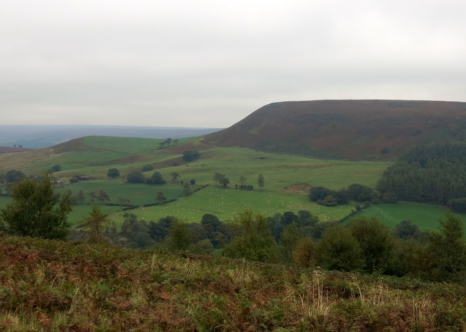
The village sits under Hawnby Hill (298m) whose twin, Easterside Hill, can be seen over towards the B1257. These two hills, known as Corallian Outliers, once formed part of the Tabular Hills and have a very distinctive shape. We left the road opposite the Inn and immediately started to climb across a field, fighting through high bracken that's now beginning to die back, until we reached the top of Hawnby Hill. From here there is a good view in all directions, to the left down to Arden Hall and to the right, Easterside Hill.
 |
| Our path goes up through the trees, opposite the Inn |
 |
| Across a field and through more trees following way-marks |
 |
| Looking back at Lower Hawnby as we climb |
 |
| We reach the top.... |
 |
| ... and to the right is Easterside Hill |
 |
| ... and to the left Arden Hall below us |
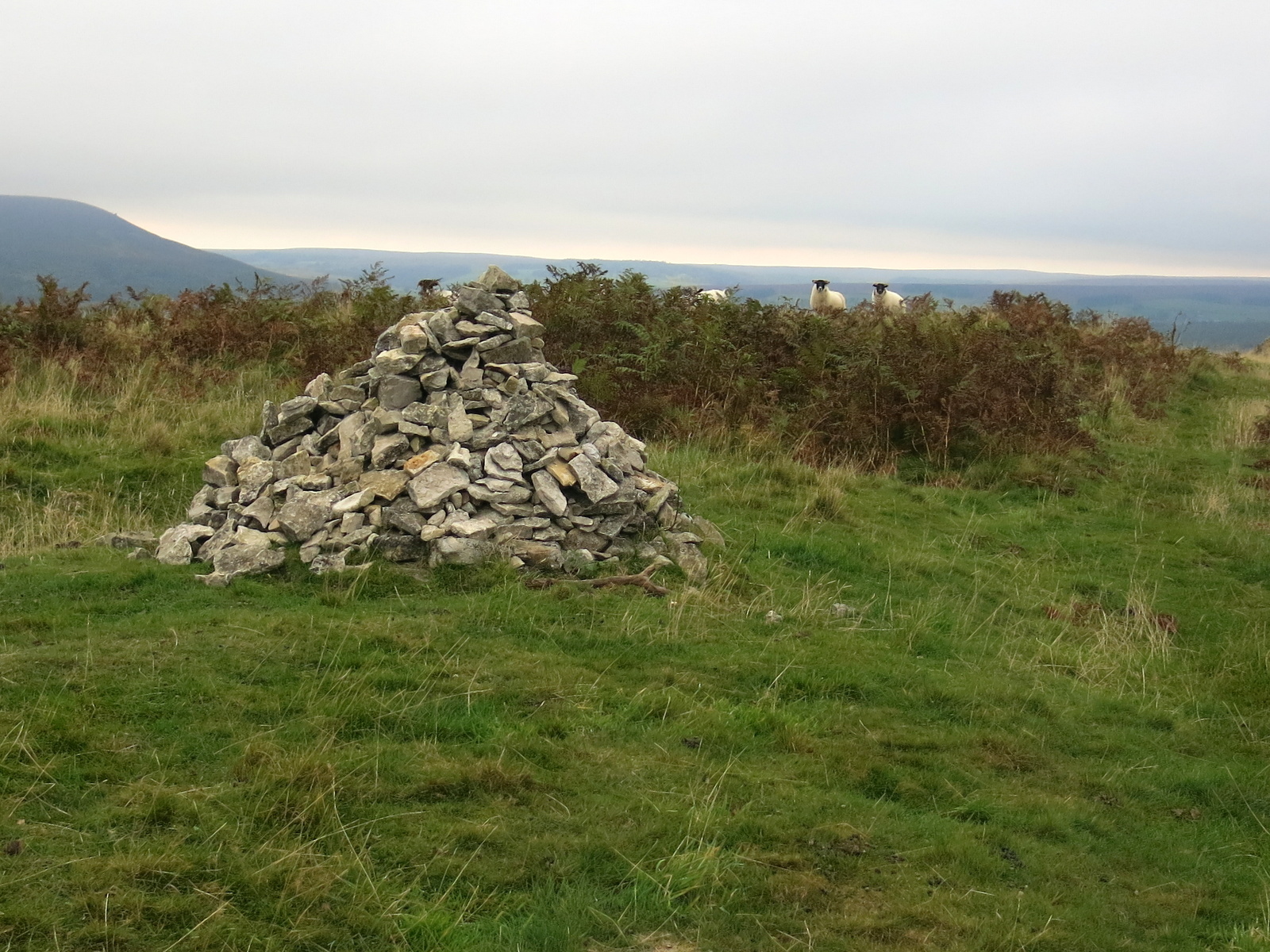
We walked along the ridge of Hawnby Hill until we reached a large cairn, which has always looked so regular that Clive and I have suspected it to be the work of one person. Today, however, it looked decidedly untidy, as if it had been knocked down and piled up again and loose stones were lying about nearby. We wondered why it had been knocked down and then rebuilt, but not as well. It is however, still placed at the highest point of the ridge at 978 feet.
Just beyond the cairn a small flock of sheep were baaing noisily and as we approached them we saw the reason, a young sheep lying dead with no sign of injury or illness.
 |
| Untidy cairn and unhappy sheep |
 |
| Neat cairn last time we walked here |
 |
| Clive spots the reason for the unhappy sheep |
 |
| A sad sight |
We walked along the ridge to the end of Hawnby Hill enjoying picking out familiar sights and walks that we could see from this vantage point, and then descended to Hawnby Moor and the moor gate at Sunley Slack.
 |
| Looking over to the trees of High Paradise in the distance |
 |
| The end of the ridge, looking towards our path across the moor |
 |
| Sign by the moor gate |
We passed the notice board and walked along the sandy path of Sunley Slack coming to a fork in the road after about a mile. We took the left fork and followed the path, seemingly walking straight towards Bilsdale Mast. To our right was Round Hill which is simply a collection of rocks and a bump in the heather.
As we walked we saw a dead adder lying on the sandy path. This is only the second adder we have seen in all our wanderings, the first being very much alive.
 |
| Sunley Slack |
 |
| Looking back at Hawnby Hill |
 |
| Dead adder |
Just past Round Hill we came to a marker post with a yellow way-mark pointing right towards Chop Gate, and we knew we needed to turn left about 20 feet beyond, into the heather. There is very little sign of the path indicated by Tom Scott Burns in the map above, and we made our way sometimes through heather and sometimes on sheep tracks, all the time heading towards Hazel Head Wood which we could see in the distance.
As we walked over the moor we passed a series of shooting butts that shooters step down into. The walls are lined with wood panels and if a creature falls in there is no way for it to escape. In the past we have found baby rabbit skeletons so we always check inside. In the first we saw a dead mouse and a couple of butts later we saw a large toad sitting forlornly in the corner, on the gravel floor. Clive lifted him out and returned him to the wet heather.
 |
| Turn left about 20 feet past this sign |
 |
| Across th heather to Hazel Head Wood |
 |
| Skeleton in a shooting butt, a shrew? |
 |
| Trapped toad |
 |
| Returned to the moor |
We walked alongside the wood, gradually dropping downhill until the ruined Wesleyan Chapel suddenly came into view. Alongside the wood are numerous ants nests, some up to three feet tall.
We reached the chapel and used a couple of its fallen stones as seat and table while we enjoyed our coffee and scones with a nice view over towards Bow Gill and the Osmotherley road.
 |
| Approaching Hazel Head Wood |
 |
| We saw a few frogs/toads lurking in the wet heather |
 |
| Ants nest |
 |
| The old Wesleyan Chapel comes into view |
 |
| Looking through nettles to the old altar |
We retraced our steps and entered Hazel Head Wood, quickly coming to some ruined buildings. TSB says these once belonged to High Hazel Head Farm which was last inhabited in 1946, surprisingly recent considering the state of the ruins.
We followed a grassy track through the dark wood until, bearing left, we exited the wood above Hazel Head Car Park and the Osmotherley to Hawnby road.
 |
| Looking back at the moor on entering Hazel Head Wood |
 |
| Unwalked path through the trees |
 |
| The ruins of High Hazel Head Farm amongst the trees |
 |
| Leaving the wood |
 |
| This was all trees when TSB drew his map in the '80s |
 |
| Reaching the Osmotherley road |
From the car park we followed the road left for a short time before turning into Ellers Wood at a footpath sign. This stretch seems unwalked and is made difficult by self-seeded saplings which obstruct what used to be the footpath.
 |
| Head for the telegraph pole and turn left |
 |
| The conifer wood is a bit depleted since our last visit |
We followed the track alongside a beck and then into the trees of Blueberry Wood. This whole area was wick with young pheasants which ran along the path in front of us. There were feeders every few yards. Eventually we emerged from the conifers above St Agnes House Farm and to a surprise view.
 |
| Surprise view to St Agnes Farm |
Passing St Agnes House Farm we dropped down to a ford where we crossed a footbridge into Low Wood. Soon we came to the attractive arched bridge over the Rye, not mentioned by TSB as it post dates his book, being built to replace a bridge washed away by flooding in 2005.
 |
| Leaving the path to drop down next to St Agnes House Farm |
 |
| St Agnes House Farm |
 |
| Bridge intro Low Wood |
 |
| First sight of the arched bridge over the River Rye |
 |
| The bridge even has a tarmac surface |
 |
| Looking downstream from the bridge |
From the bridge we had a short scramble up to a track leading right, coming out of the woods at the lonely Carr House. From here we followed way marks (but no path) through several fields in a rain shower. Soon we rejoined the Hawby road and walked first into the village and then into the Inn at Hawnby where we discussed our walk with the landlord over a pint of Black Sheep Ale. A fine end to a nice walk.
 |
| A heavy shower |
 |
| Goose with clipped wing, probably from St Agnes House Farm |
 |
| Rejoining the Hawnby road. |