Hasty Bank, Cold Moor and Upper Bilsdale
8 miles Dull and windy
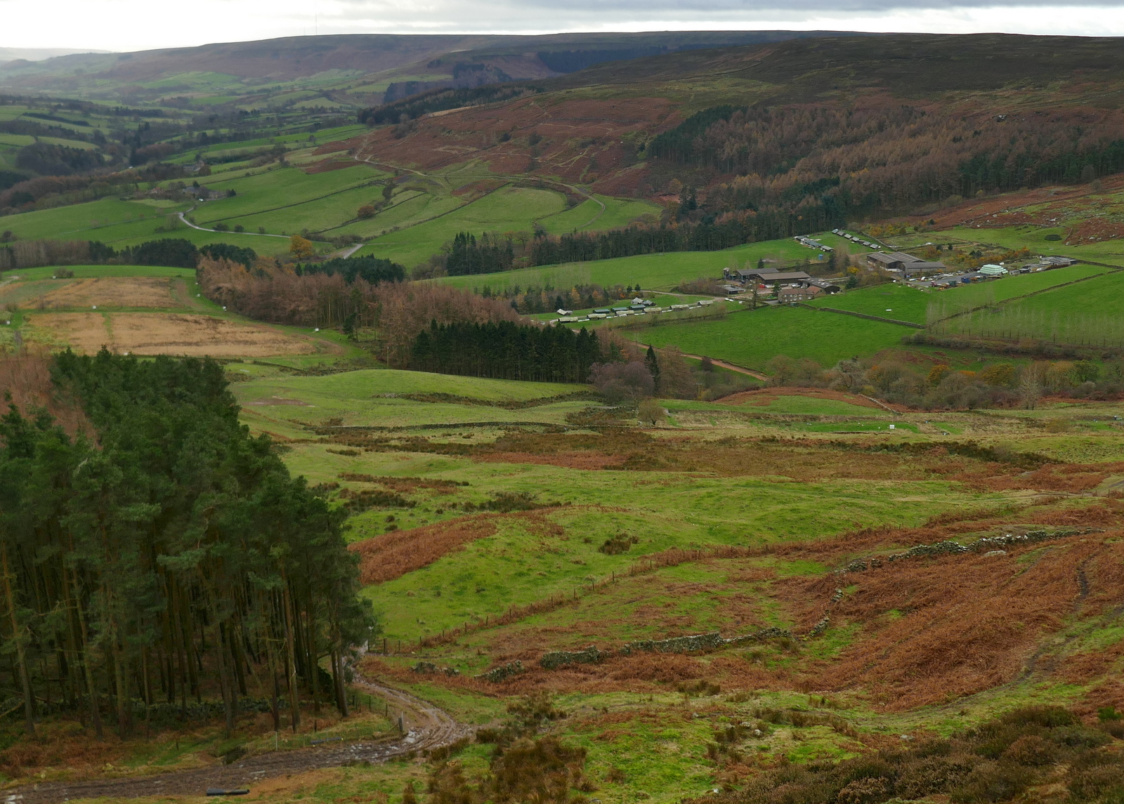
We parked at the top of Clay Bank and crossed the road to climb Hasty Bank, but instead of following the Cleveland Way to the top, we branched left just after the gate, on a small track that winds its way upwards to reach the Old Quarry, shown on the map below.
 |
| Today's walk from The Walker's Guide to the Cleveland Hills |
 |
| Approaching Hasty Bank |
 |
| Immediately bear left on the small path |
The reason for this diversion was that we wanted to pay our respects to 'The Lady of Bilsdale', described by Tom Scott Burns as 'the enigmatic face of a lady carved on a rock wall who gazes eternally down into Bilsdale'. This ancient stone face was carved into the side of the Old Quarry shown on the map above, perhaps by one of the workers. The track led us gradually up and around Hasty Bank and we came to the quarry on our right before walking over to admire the Lady and share her view of Bilsdale.
 |
| Looking back towards Clay Bank |
 |
| A gradual climb |
 |
| Bilsdale below |
 |
| We reach the old quarry |
 |
| The Lady of Bilsdale |
 |
| The Lady's view down into Bilsdale |
Leaving the Lady we followed the edge of the moor to reach The Wainstones, where we picked our way carefully through the rocks before descending into Garfitts Gap and climbing onto Cold Moor. TSB says that the name Wainstones is believed to derive from the Saxon 'wanian' - to howl, and that the naming of the stones means 'stones of lamentation'.
 |
| Circumnavigating Hasty Bank |
 |
| Holme Farm below |
 |
| Approaching the Wainstones |
 |
| The Wainstones |
 |
| Beginning the climb of Cold Moor |
 |
| Looking back at The Wainstones from Cold Moor |
We now walked along ridge of Cold Moor (1318') for 2.5 miles into a stiff head wind. To make up for the discomfort we had a fine view as far as the Pennines over to the west and Roseberry Topping and Easby Moor to the east. Eventually we took a clear fork to the left, taking us gently down to the village of Chop Gate. This track is known as Cold Moor Lane and we passed through a gate where our path became a hollow lane. TSB says that it is possible that this passageway was established by prehistoric man and has continued in use throughout history to the present day.
 |
| We enter Cold Moor Lane |
 |
| Very muddy track |
 |
| ... soon becomes a hollow lane |
 |
| Thomas Leckenby on Urra Moor, from 'Round and About the North Yorkshire Moors' by Tom Scott Burns |
We soon reached Chop Gate to emerge at the old Wesleyan Chapel which is almost hidden between houses. The reason for the strange location of the chapel is that the landowner, Lord Feversham, was C of E and totally against a non-conformist church being established in the dale. However, a local shop keeper sold the Methodists this plot of land and the chapel was built in 1858. TSB reports that it contains an interesting harmonium (pump organ) but it was sold some years ago and we think is awaiting conversion for housing.
 |
| The old Wesleyan Chapel |
 |
| Being converted to housing. |
TSB says that the name Chop Gate is thought to be derived from the old Scandinavian term kaup meaning pedlar and with a number of pannier tracks converging on the village it must have been like a market place in times gone by.
We turned left into the B1257 and walked along to Seave Green whose name is thought to derive from its owner in 1301, Nicholas del Seves. Here we crossed the road to the tarmac track to Bilsdale Hall. On the left we passed Chisel Hill Mill which ceased operation in 1930 and later became a recording studio that was used by Chris Rea in the 1980s. The studio's name became the subject of one of his songs, Chisel Hill, which some people mistakenly think refers to Roseberry Topping.
 |
| Weather vane at Chop Gate |
 |
| Crossing the bridge to Seave Green |
 |
| Chisel Hill |
 |
| Bilsdale Hall |
Reaching Bilsdale Hall we left our route to follow a lane to St Hilda's Church where we stopped for coffee and scones.
The attractive church was rebuilt in 1851 in the shape and style of the original church but sadly we have yet to find it open to visitors, today being no exception.
We sat on a bench near its entrance and enjoyed our coffee with a fine view of Bilsdale.
 |
| Bilsdale Priory |
 |
| We arrive at St Hilda's Church |
 |
| Model hawk to deter nesting birds |
 |
| Coffee with a view |
After finishing our coffee we explored the graveyard where there are some ancient stones, many with interesting though maudlin verses.
 |
"A daughter wife and mother sleeps below, how many ties were severed with one blow, wives daughters mothers all ye mortals see, how scant the term of human life may be, live a true life and death in vain will call, who lives in Jesus will not die at all"
|
 |
| "Sleep on blest creature in thy urn, Our sobs and tears cannot awake thee, Weel (sic) stay until it be our turn" |
Coffee finished we returned to Baysdale Hall where we re-joined TSB's route and began the steep climb up to follow the alternative dotted path on the map above, going steeply uphill to reach Urra Moor at Medd Crag.
 |
| Walking alongside Bilsdale Hall |
 |
| Recently deceased and no sign of injury on the hare |
 |
| Looking down to the red roof of Bilsdale Hall |
 |
| Through the moor gate |
 |
| On Urra Moor |
After pausing to admire the view and regain our breath we turned left and followed the ridge, with a succession of sweeping views of Bilsdale below us. As well as being on the ridge of the moor we also noticed we were walking alongside the remains of an earthworks. This earthworks stretches for 2.5 miles and its origin is forgotten, perhaps defensive, or it may have been an animal enclosure. It was known as Cliff Dyke, and a couple of centuries ago as Cromwell's Lines.
TSB mentions two witches who inhabited Bilsdale's moors, Peg Humphreys and her companion Alice Wood, who was said to take the form of a cat or hare.
 |
| The Wainstones and Garfitt's Gap in the distance |
 |
| Following Cromwell's Lines |
 |
| Maiden Spring |
 |
| Clive jumping Maiden Spring |
We followed the earthworks and eventually came to a little valley where we crossed a stream known as Maiden Spring, at 1300'. Leaving the beck we continued to follow the earthworks until rejoining the Cleveland Way track on Carr Ridge. We turned left and walked steeply down to Haggs Gate to rejoin the main road for a few yards returning us to Clay Bank Car Park and the car.
 |
| On Carr Ridge |
 |
| Descending Hagg's Gate, the car park in the distance |
A short drive and we were soon enjoying our debrief of this enjoyable Tom Scott Burns walk.
 |
| "To Cromwell's Lines!" |