The Rosedale Railway and Botton Head from Ingleby Greenhow
8.5 miles Mainly fine and cool
Tom Scott Burns notes in his Walker's Guide to the Cleveland Hills, that the name Ingleby has been written in various ways over the years including Angleby, Engelbi, Yngleby and Yngylby. During the reign of William II (1087-1100) Guy de Baliol was granted the barony of Ingleby and it remained in his family until the 13th century.
We parked in Ingleby Greenhow in the overflow car park for the Dudley Arms and walked back to the main road, in the direction of Kildale. Our route left the road alongside a newly built house and we followed an overgrown path onto meadows.
 |
| Today's walk from The Walker's Guide to the Cleveland Hills |
 |
| Turn off road between houses... |
 |
| ... into track between houses |
 |
| ... leading to fields |
Apart from the moorland trails our paths today were little walked and overgrown in most places. We crossed a field with sheep, adjacent to Ingleby Manor and then several meadows, to arrive at Bank Foot Farm situated under Turkey Nab, which is probably derived from the old personal name Thorlkil. Tom Scott Burns says in his Walker's Guide that in 1729 William Parkin was hung from gallows mounted on Turkey Nab for murdering his brother-in-law at Great Broughton.
 |
| Ingleby Manor |
 |
| Arriving at Bank Top Farm |
We joined the bed of the old railway track at Bank Foot and turned right to walk towards the incline bottom. After a couple of miles we passed by some old railway cottages and reached the stiff gradient of the old incline railway.
 |
| Old railway track from Bank Foot |
 |
| Old railway cottages |
 |
| I spot a 'new' blacksmith weather vane but can't get a clear shot! |
 |
| Bear left for the Incline |
Tom Scott Burns tells us that the old railway was completed in 1861 and leads to the foot of the incline bank where the trains were loaded with ironstone. The incline reaches a maximum gradient of 1 in 5 and a brake drum house was situated at the top. Three empty wagons were hauled by steel ropes as three loaded wagons descended, an operation which took 3 minutes at a speed of 20mph, regulated by the drum house.
 |
| Mine workings from the Incline |
 |
| Gate near the top of the Incline |
 |
| The graffiti is between the gate and the top on the left as you climb |
 |
| Looking back down the Incline |
 |
| Our passing is noted |
We climbed steadily and passed by some old graffiti of a man wearing a stovepipe hat with a bird in front of his face. TSB suggests that this is a satirical caricature carved by a railway navvy in a moment of inactivity.
 |
| Old drum house ruins |
 |
| Greenhow Moor |
 |
| Well situated bench |
 |
| Ideal for a coffee stop |
 |
| Our view from the bench |
Reaching the top we looked at the remains of the drum house and then continued along the old railway line until we came to a bench looking down into Greenhow Botton. This seemed an ideal spot for coffee and scones, and so it was.
Resuming, we turned right off the old railway, which officially closed on 13th June 1929 and now makes a nice 11 mile path to Farndale, Westerdale and Rosedale and joined a trail to Cockayne Head and Botton Head, which is also part of the Cleveland Way. As we walked this trail we came to two old boundary posts, the first known as The Face Stone is mentioned in a 1642 document for the Helmsley Estate, and the second showing a carved hand near to Round Hill dates from 1711. Near the Hand Stone is the trig point at Botton Howe which is located on a Bronze Age burial mound at 1490 feet, the highest point on the North York Moors.
 |
| Face stone |
 |
| Old trig point |
 |
| Hand stone |
 |
| New advice board |
We walked back to the wide path and continued walking across Urra Moor, which according to TSB derives from the Old English 'horh' meaning 'filth'!
We noticed a partridge walking slowly towards us along the path. It seemed unhurt although short in the tail feather department, and after eyeing us beadily continued along its way.
 |
| Seemingly unafraid |
We heard a quad bike behind us and it stopped alongside, the driver obviously wanting a chat. He told us he was looking for sheep that had dodged shearing and had a pen of 17 further along, where he was now going. He showed us his electric shears and his hand shears which he had in a case on the front of the quad. In answer to our questions he pointed out the boundaries of his land (he was a Bransdale man) and the area covered by the neighbouring shepherd, ( a Baysdale man) but said they crossed each other's land all the time as the sheep knew no boundaries.
We admired his dogs and he told us that the one standing in front of the quad was 5 years old and bought from Ripon, its sire being worth a thousand guineas, and that he had bred the other, which was now 9 years old.
 |
| Looking towards Clay Bank |
 |
| Well met, the shepherd stops for a chat |
 |
| Looking across at our walk up! |
Eventually we came to a signpost and an indistinct path right that we followed to quickly drop off the moor down Jackson's Bank and into Greenhow Plantation.
 |
| Turn right to Jackson's Bank |
 |
| Descending Jackson's Bank |
 |
| Forestry work going on today |
We reached the lane down Greenhow Bottoms and over to the right we could see the incline railway while ahead of us Roseberry Topping appeared in the distance. A mile or so further on the tarmac lane and we reached Low Farm where we stopped to feed an apple to a horse.
 |
| Texel Ram |
We turned right, following a footpath sign into Low Farm where we admired their 'ancient' stone circle and appropriate weather vane.
 |
| 'Ancient' stone circle at Low Farm |
 |
| Weather vane at Low Farm |
Our path turned left before the farm buildings into fields which we crossed, one after another, on an unseen right of way, aiming for the yellow right of way signs at the field boundaries.
After a mile of field walking our path veered right into bushes and descended on a slippery paved trod to reach the bridge over Ingleby Beck, and next to the bridge, the old church of St Andrews.
 |
| No apparent path but yellow way marks on fences |
 |
| Descending old trod to Ingleby Beck |
 |
| Over the bridge.. |
 |
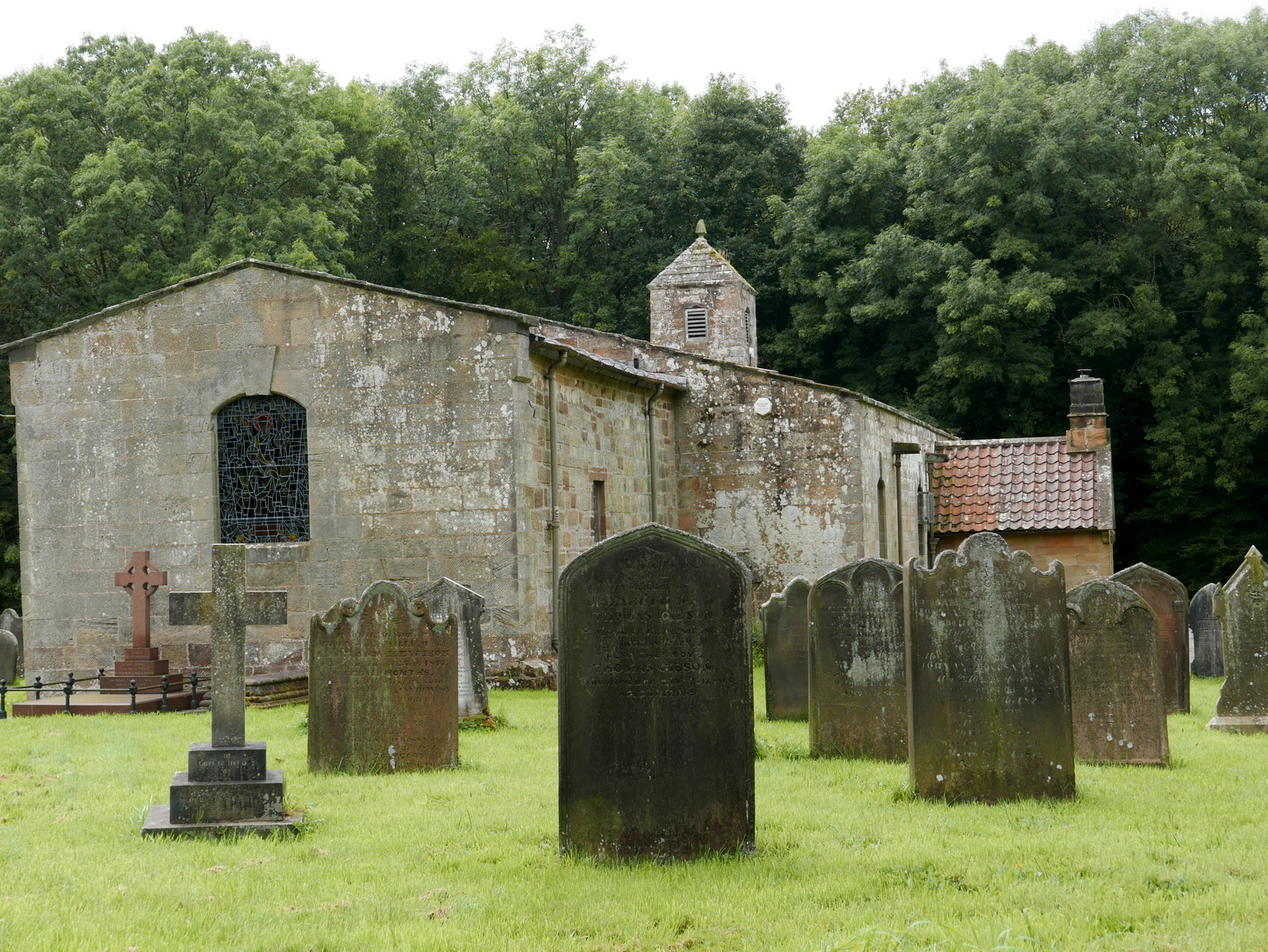
| .. to St Andrew's Church |
The church was unlocked so we entered and had a look around. The original church was granted to the Bishops of Whitby in 1143 by Adam de Ingleby and still retains traces of Norman work, we liked a nice pig effigy on one pillar. Apparently the church was rebuilt at the parishioners' expense in 1741.
 |
| St Andrew's Church |
 |
| Altar window |
 |
| Looking to the rear of the church |
 |
There are two recumbent effigies, one of
a knight (probably C15)...
|
 |
.... and the other, a priest (Willimus Wrelton, incumbent c.1300)
|
|
 |
| Original Norman carvings.. a caricature? |
 |
| .. a dog? |
 |
| .. a boar or pig |
 |
| .. a dragon or serpent? |
 |
| St Andrew's Church, Ingleby Greenhow |
We both agree that this walk of TSB's is very enjoyable, with a bit of everything; hills, moors, farms and woods and deserves to be walked more frequently to prevent many of the paths falling into disuse.