"There must be dales in Paradise
Which you and I will find.."

Friday 25 October 2013


Kirby Knowle to Felixkirk and Boltby

8.5 miles        Warm and sunny


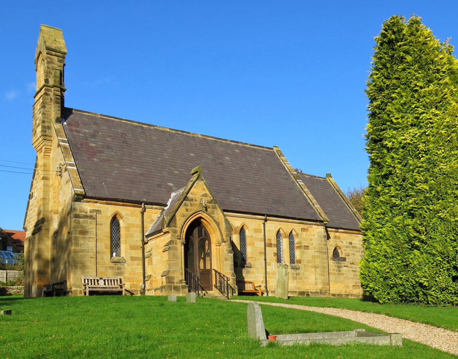
We drove to Kirby Knowle via the A19 Knayton turn off and parked at the end of the village on the grass verge, opposite the chuch.


 Today's walk from The Walker's Guide to the Hambleton Hills by Tom Scott Burns


St Wilfred's Church, Kirby Knowle


We left the car and walked back along the road for .75 mile until we almost reached Upsall, where we turned left into a meadow and then trekked over fields, through small woods and negotiated two becks, neither of which had a bridge.   The walking was pleasant in the sunshine but the grass was very wet and our trouser cuffs were soon soaked.


 Crossing Turton Beckstead


Our path reached a road on the outskirts of Felixkirk and we decided to have a look at the old church, which was unlocked, very tidy and unusually for a church, felt warm and inviting with sun streaming through the windows.  We looked round the graveyard and the Victorian epitaphs on some of the gravestones made one feel quite sad.


 The Church of St Felix


'Afflictions sore did I bear
Physicians their skill tried
I left my wife and children dear
For God to be their guide'


'Hannah, the lamented wife of David Cornforth'
'20 years I was a maid
1 year I was a wife
18 hours a mother
And then departed life'


We returned to the outskirts of Felixkirk where, after a small unintentional diversion we returned to our route and walked up a narrow road past the lodge to Mount St John.  A few hundred yards later we left the tarmac and followed a farm track towards Cinque Cliff House where a new footpath diversion took us round the house via a meadow.  This field gave us a good view down into the surrounding countryside and we decided it was the perfect spot to have our coffee and scones.  


 Lodge to Mount St John


 The view from our coffee stop


 It was nice to see Hedgehog ladders in all the cattle grids in this area!


Green lane towards Thirlby

We walked along an old green lane which eventually reached the road close to Thirlby, a pretty village where we came to a house called Pear Tree House, next to the river.  This house is owned by the family of Bob Hunter, a cabinet maker who used to work with 'Mouseman' Thompson at Kilburn.  Bob was known as the 'wren man' and marked his furniture with the carving of a wren.  http://www.wrencabinetmakers.com  We looked through the window and could see a small display of furniture for sale.  The door was unlocked so we popped in to admire the handiwork which was unfortunately out of our price range!


Pear Tree House, Thirlby


Home of the 'Wren Man'


Thirlby


We crossed the ford in Thirlby and turned left into meadows at Thirlby Farm.  Our track here was barely discernable in the grass and we relied heavily on the yellow right of way markers on the field bounderies.  We passed an old farm called Tang Hall and followed the beck upstream to the village of Boltby.


 The escarpment behind Thirlby


 Following the faint path across meadows


Holy Trinity Church at Boltby


We left Boltby turning left at a small bridge across Gurtof Beck and walked past a field containing a horse and a handsome ram.  Both ran over to see us and each was rewarded with a cough sweet which they seemed to thoroughly enjoy.


 Clive shares his 'Jerksons Throat and Chest Lozenges' with his new friends


 Lazy dining


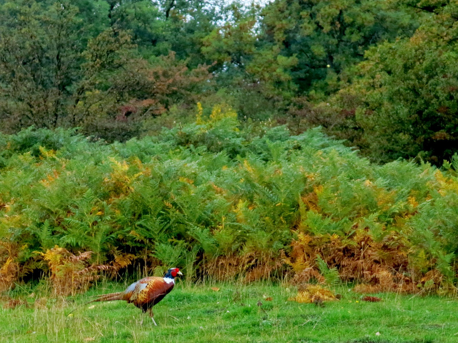
We now commenced what should have been the last leg of our walk, back to Kirby Knowle.  As we walked through a field we came across a partridge sitting in our path, which on inspection appeared blind.  Clive examined it and found it had corn in its crop but both eyes were closed.  As we debated whether to dispatch it humanely a 4x4 drove slowly along the track towards us.  It was the farmer who told us that the gamekeeper was up ahead and he would tell him about the bird.  He could decide what to do and whether it could be helped.  We replaced the bird on the path and followed the landrover up towards Westow Conifer plantation.  We were so engrossed in our conversation about the bird that we missed our turn and continued into and up through the plantation until we reached the top edge, looking down onto the village of  Cowesby which is far north of where we should have been.  We realised we had lost our way and after checking the Ordnance Survey map we walked left along the perimeter of the woods and eventually down to arrive at Kirby Knowle and the car, an hour later and a couple of miles further than anticipated.   At least a ten miler for us today but the unseasonal warm sun and fine views made it a pleasure!


 'Blind' Partridge

Is that Cowesby below - where are we?!


 Finally walking back down to Kirby Knowle


NB   An internet search reveals that game birds are susceptible to a disease called Pseudomonas

which causes blindness.  See here.

Saturday 19 October 2013


Walking in the Lakes this week. 


The lion and the Lamb
(but which is which?)

 
Day 1  Gowbarrow Fell
Day 2  The Greenburn Valley

Friday 11 October 2013

Rievaulx Abbey and Caydale from Murton

8.5 miles      Wet and cold with a blustery wind


We parked in the same spot as last week, on the roadside near Murton Grange.  We set off walking past Murton Grange and turned left into a cart track known as Ox Pasture Lane.  After a while thick blackthorn hedges protected us from the north wind and gusts of rain.  Pheasants and partridges were sheltering in the lee of the hedges and took to the air as we approached except for one little partridge that sat, head bowed, looking very sorry for itself.  We walked up to it and I took a photograph; its eyes were closed and it looked very ill.  Clive said he had better put it out of its misery and as he reached out to take hold of it the partridge's eyes opened, it squawked in alarm and set off at speed, zig-zagging along the path before taking to the air.  Presumably it had been asleep and because of the wind hadn't heard us until Clive spoke!


Tom Scott Burn's map of today's walk from The Walker's Guide to the Hambleton Hills


 On Ox Pasture Lane


Blackthorn hedges along Ox Pasture Lane


Ill?  Dying?  No, just dozing..


Our path continued alongside Deep Gill Wood and then gradually descended into the Rye Valley giving us nice views down to Barnclose Farm where we joined a tarmac farm track that led past Tylas Farm.


Deep Gill Wood


Looking down at the Rye Valley


 Toadstools in Deep Gill Wood


 As we leave the woods we get a surprise view of Easterside Hill in the distance


We left the road and a narrow track took us alongside the River Rye.  This track had become very muddy in the rain and at one point neat boarding had been laid to walk alongside the river.  We came to Bow Bridge and crossed the river and walked past the old quarry shown as Penny Piece Quarry, where the limestone was excavated for Rievaulx Abbey in the 12th century.  The monks dammed the river here and diverted the water into a canal which carried the stone on barges to the site. The canal is still clearly visible although full of bushes and shrubs.  It was narrower than I had expected, only about 10 feet or so across.


 Walking along Oxen Dale, the River Rye to the left


 Neat boarding helped our progress


Bow Bridge


 We join the Inn Way 


                                                           Our first view of Rievaulx Abbey

Rievaulx came into view and looked splendid when approached from this direction.  We eventually reached Rievaulx Village and found ourselves a low stone wall to sit on whilst we enjoyed our coffee and scones, looking across at the Abbey.  The sun even shone for a while to celebrate the occasion.


A beautiful approach to the Abbey


The village of Rievaulx


                                                       The view from our coffee spot


We walked along the tarmac road out of the village with views of the Abbey to our left.  We crossed Rievaulx Bridge and started to walk on the other side of the river, still on the road, to Ashberry Farm.  The path left the road here and went behind the farm and around the base of Ashbery Hill where Tom Scott Burns notes there is a 'stunning view of the monastery' below.  Unfortunately new conifer growth prevented us from enjoying Tom's view and this growth accompanied us all along this stretch until well past the point where a view of the abbey was possible.


Rievaulx Bridge


Views of Ashberry Farm


We continued along this path for some distance.  Crossing a cattle grid Clive pointed out that it was made of narrow gauge railway lines.  We have seen several cattle grids like this, some still showing the bolt holes where they had been joined together.  This is a legacy of all the quarrying in the area where rail track was used to move the minerals and it was pleasing to see materials being re-used for other purposes.   We walked alongside the quaintly named Lambert Hagg Wood before rejoining the farm road near to Tylas Farm and retracing our outward journey for a while before heading left into Birk Bank Wood.  Horses had been ridden through these woods and our track was a quagmire made even worse by the persistent rain.  We came out of the woods and rejoined the road at a ford next to Caydale Mill.  We washed the mud off our boots in the ford before following the road steeply uphill for a while and then onwards to Murton Grange.  As we passed last week's wall repairs a rainbow appeared over Murton Grange; the end of the rainbow seemed to be just where Clive had parked his car.  There was to be no pot of gold in his car however, just our muddy boots.


Cattle grid made from narrow gauge rail track


 Leaving Lambert Hagg Wood


Entering Birk Bank Wood


Cleaning boots at the ford


A rainbow at Murton Grange