"There must be dales in Paradise
Which you and I will find.."

Sunday 20 August 2023


Hazel Head to Arnsgill and Cow Ridge

          7 miles                       Fine and still


We approached Hazel Head Car Park via a 6 mile drive along the unclassified road from Osmotherley to Hawnby and after driving past the ford at Blow Gill ('ravine with the dark ford') we parked at Hazel Head car park.

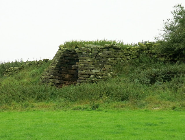
After donning our boots we returned along the road, back to Blow Gill where we admired an old lime kiln at the side of the road, the first of three we would pass today. 


Today's walk from The Walker's Guide to the Cleveland Hills

Blow Gill


Limekiln at Blow Gill


Tom Scott Burns explains that a number of farmers in the region had their own lime kilns for burning lime, which was used for lime washing walls and dressing the land, a custom going back to Roman times. The lime neutralises the acid in the moorland soil allowing more varied crops to be grown. 

Leaving Blow Gill we followed the road steeply uphill to reach the entrance to Street Gate Farm, where we turned left onto the farm track.


Passing Street Gate Farm

Trap near Street Gate

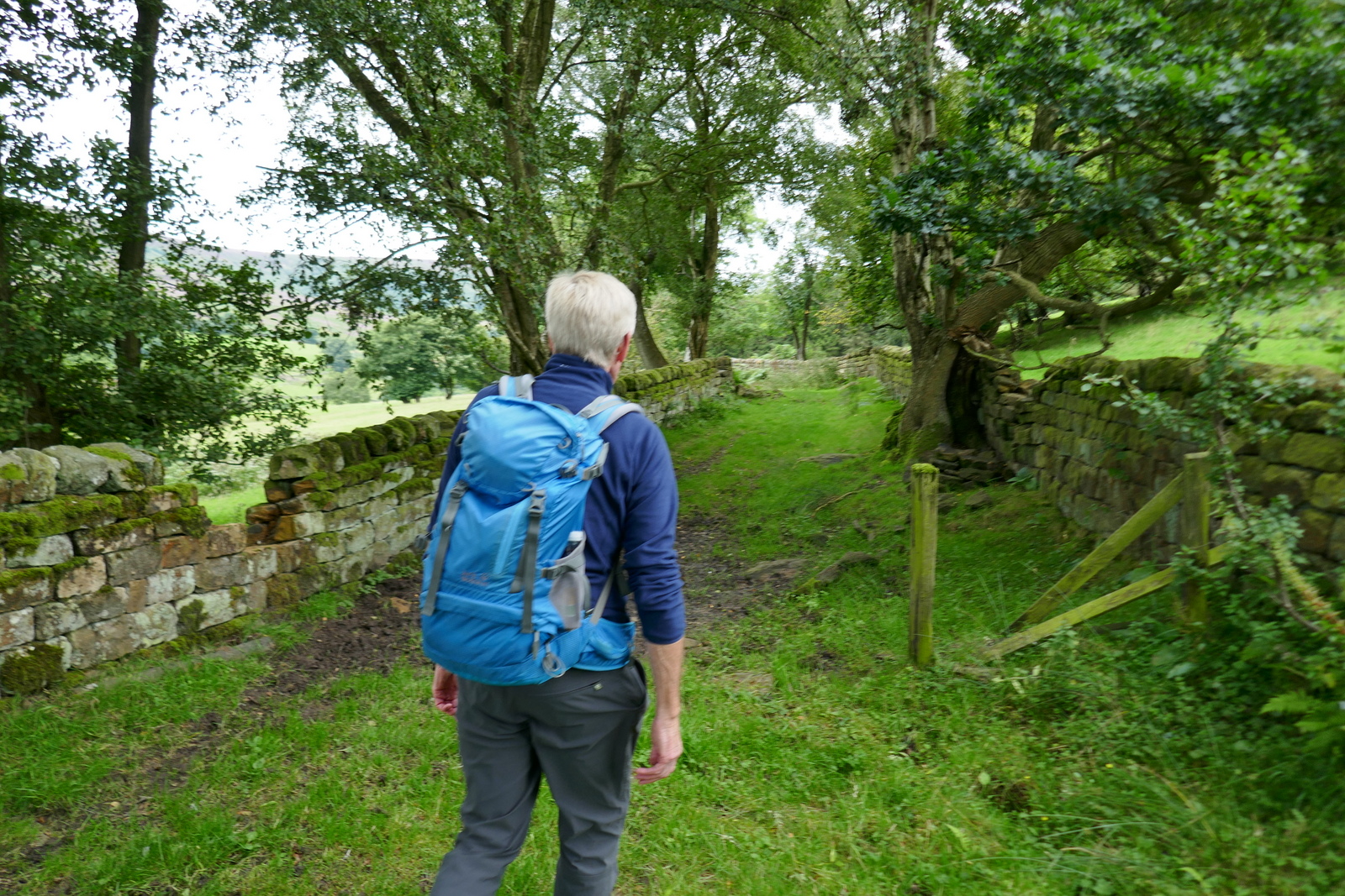
The farm track is overgrown and very muddy in places.  It leads past Street Gate Farm and into South Wood.  This is an old lane and TSB tells how these lanes were used by tinkers and pedlars who became very numerous in the Middle Ages.  These travelling salesmen not only sold their goods but also played a big part in circulating news and delivering letters between settlements.

The track led us past another farm, Hagg House, and on until we reached Birk Wood Farm where we turned right just before the building and climbed steeply to rejoin the Osmotherley to Hawnby road. Here we paused to examine another lime kiln, which probably once belonged to Plane Tree farm.


Hagg House Farm

Old lane

Gets muddy in places


Turn right onto tarmac at Birkwood Farm

Lime kiln near Plane Tree Farm


We left the Lane at a gate opposite the Birkwood Farm entrance, to start another steep climb to reach the moor.  Passing the moor gate we walked along the edge of the moor, looking west to the grand building of Snilesworth Lodge.  Eventually the path drops from the moor to reach Arnsgill Beck which is crossed by a footbridge, just before Hill End Farm.

Easterside Hill and Hawnby Hill in the distance

Moor gate

Heather honey

Busy bees


Overpowering scent of heather pollen

Keeper's cottage below

Descending to Arnsgill Beck

There were bees buzzing everywhere in the flowering heather and a very strong smell of pollen as we crossed the moor.  Later, on the way home, we would stop at a roadside stall in Osmotherley and buy honey collected from the hives we passed near Plane Tree Farm.

Climbing from Arnsgill Beck we passed Hill End Farm and walked on to Arnsgill Ridge with Snilesworth Moor to our left.  TSB says that in 1150 Snilesworth was written as Snigleawath, meaning Snigels' Ford, based on the Norse word snigill, a snail.


Hill End Farm

Lime Kiln at Hill End Farm

Snilesworth Lodge

Our climb took us past the farm to the top of Arnsgill Ridge where we joined a shooters' track to pass through the moor gate and walk towards a distant plantation of conifers. We followed the track until it drops down to Head House.

Stoat trap

Head House

Head House is always unlocked and makes a good shelter in bad weather but today we walked on and dropped down to re-cross Arns Gill and then climbed to Cow Ridge.  We strode out along the moor path for a couple of miles.

We came to a cairn which marked the location of Iron Howe.  TSB points out that all along this stretch are well preserved field boundaries and over 300 cairns dating from 2300 to 800BC.  Although they don't show well in the photographs they are in fact very noticeable as you walk along this stretch of the path.

Iron Howe


Remains of ancient settlements


After Iron Howe we descended gradually back towards Blow Gill.
On our left we spotted the old Wesleyan Chapel ruins, where we have stopped to rest on TSB's Hawnby to Hazel Head walk.  Below us we saw the unusually named Scotland Farm, and now on tarmac we dropped back to Blow Gill and the end of the walk.

Scotland Farm


Wesleyan Chapel ruin

The end of the walk


Thursday 17 August 2023


Two Days in the Lakes

Day 1    Rosthwaite Circuit

Day 2    Skiddaw via Ullock Pike


Ullock Pike from Skiddaw


Friday 11 August 2023


Kildale to Baysdale and its Lost Abbey


9.5 miles                                      Hot and still


We parked at the side of the road in Kildale village before setting off towards Little Kildale.  A hot day for walking with temperatures around 26C, little or no sun and no wind.


Today's walk fromThe Walker's Guide to the Cleveland Hills

We parked at the side of the road here

Kildale house


We walked past Kildale Hall..

.. and turned right towards Little Kildale

Little Kildale


Tom Scott Burns informs us that Kildale is a village of great antiquity.  There are several 'Kildals' in Norway and the village was probably named by the Vikings.  It was called Childale in the Domesday Book.   In 1156, where the church now stands, was a wooden castle built by the Percys, Earls of Northumberland.  Walking through the village we turned off the road into Green Gate Lane and climbed towards Little Kildale.  Reaching the hamlet we continued along our lane through Little Kildale Wood, eventually reaching Warren Farm where we turned right towards the open moor.

Pigeon weather vane in Little Kildale

Little Kildale

David Brown tractor

Obviously fully operational


As we walked towards Warren Farm we saw estate workers busy in the fields filling feeders for the pheasants which had obviously just been released and have yet to learn to avoid people.

Recently released

Pheasant season begins 1st October so time to fill out and become more wary

Cover grown for game birds


Following the path past Warren Farm which is hidden among trees, we came to a large square chimney as we descended to Leven Vale.  This is the remains of an ironstone mine that was operational between 1866 and 1874.  Time and effort have been given to making this a site of interest so we stopped to look around.

Ironstone mine chimney


Looking from the Upcast Shaft to the Downcast Shaft


Leaving the old mine site we crossed the source of the River Leven and started a climb up through meadows towards Kildale Moor. 

The source of the River Leven

We now climbed steadily to Kildale Moor and having reached the top at 900 feet, we descended towards Baysdale Beck, soon reaching the remains of an old barn where the path turns sharp left. 

Tuck your trousers in your socks!
The three common ticks

Looking back towards Warren Farm

These signs forbidding dogs and bikes have sprung up everywhere and all have been defaced

The moor gate

Heather is at its best

Dropping into Baysdale

Turn left at the first ruined building

At the first ruined building we turned left onto a track which runs parallel to Baysdale Beck. This is an old lime road that enabled limestone to be carried from Commondale into Cleveland, and we followed this for 1.5 miles until we reached a tarmac road.

We turned right onto the tarmac road and walked steeply downhill to pretty Hob Hole and its water-splash.  The hot weather had brought families out to play and we stopped here, looking down on the water splash, to enjoy our coffee and scones.

The old lime road

Tubs of herbicide, bracken clearing?

We reach tarmac and drop downhill..

.. to reach Hob Hole

Setting off after coffee


Hob Hole was supposed to be the haunt of a mischievous hobgoblin who taunted weary travellers and TSB reports a Canon Atkinson speaking of Padfoot,  "Padfoot, a precursor of death; sometimes visible, sometimes invisible, but ever and anon padding lightly in the rear of people, then again before them or at their side, and uttering a roar unlike the voice of any known animal." 

Crossing the ford we headed steeply up the tarmac road, then turned right into John Breckon Road.  As we walked along this narrow road we had views left down towards Westerdale.

Different types of heather give many shades of purple

Wensleydale below - the colours are as shown (not enhanced)

After half a mile or so we turned off John Breckon Road to follow a heather track that returned us back along the opposite side of Baysdale Beck, eventually passing a memorial to Alan Clegg 'Who loved these moors'.  We arrived at Great Hograh Beck where there is a small stone footbridge and a wooden memorial seat.  We were interested to see a new memorial on a piece of slate.

A runner passes us on Great Hograh Moor


Great Hograh Beck

Its bridge is the work of Rowland Close

New memorial, Alan is pointing at Rowland Close's bridge

Clive reads the memorial plates on the bench

TSB notes that the footbridge was built in 1938, according to an inscription, and was the work of Rowland Close, of nearby Low House Farm.

Leaving the beck we turned right onto a wide track and followed the path across the moor.  We walked downhill and passed by the above mentioned Low House Farm to descend to reach Baysdale Beck. 


Approaching Low House Farm

Fortunately the pointer dog is tied up


Low House Farm

The ruined house from our outward walk 

Baysdale

Baysdale Beck

We passed below Thorntree House Farm before reaching the Abbey which we bypassed, walking to the north of the building.

Bat Box at Baysdale Abbey

Baysdale Abbey

The old bridge


Tom Scott Burns explains that in the middle ages land rents for Baysdale were paid with the heads of wolves, which were numerous in the area, and one can imagine this wild enclosed ravine in the 1300s, when cattle were over-wintered in the valley bottom.  In fact, TSB explains, Baysdale is derived from Basdale meaning Cow Shed Valley.  The Abbey Farm has been renovated and is now marketed as holiday lets.

The original abbey was occupied by 9 or 10 nuns from 1190 to 1539.   TSB tells how in 1304 Prioress Joan de Percy had not adhered to the monastic rules and Archbishop Corbridge had to commit the custody of the nuns of Baysdale to Roger de Kellshay, rector of Crathorne.  By 1307 Joan remained disobedient and was deprived of her post. She absconded from the abbey with some other nuns and Archbishop Grenfield ordered them back to the abbey "that they return without delay and not go outside the precincts of the abbey and serve God under the yoke of obedience..." .  Records show that in fact Joan did return to Baysdale as a simple nun after doing a year's penance at the appropriately named Sinningthwaite.

We walked away from the buildings and crossed a quaint stone bridge which is apparently the only substantial remnant of the original abbey.  Crossing the bridge we followed the road to a footpath sign where we turned right to climb steeply through fields, all the way to the dale top, at a height of 1050 feet, where we paused to admire the view back to the abbey and collect our breath. This is using the short cut shown on the map above as dotted line opposite Baysdale Farm.

The steep climb through bracken

Looking back down to the Abbey

We joined the tarmac road that runs from the Abbey to Kildale and turned right to follow it.  After a few minutes walking on this road we saw a stone memorial to the crew of a second world war plane that crashed on Kildale Moor; sadly the crew died from exposure before they could be rescued.

Baysdale to Kildale road


We followed the lane steadily down and eventually joined the Kildale road where we turned right towards the car.  We had made good time so decided to pay a visit to St Cuthbert's Church in Kildale.

Battersby below


Sparrow Hawk

The Whitby train approaches Kildale Station

We arrive back at Kildale

The approach to the church is interesting as it is made by crossing a narrow bridge over the railway line.  Below is Kildale Station and ahead the entrance to the church is framed by yew trees.

Kildale Station

St Cuthbert's Church from the railway bridge

Gargoyles and dragons on the church tower


We like this interesting modern window

Kildale Station and St Cuthbert's are depicted in the window

.. as is the shepherd and his dogs

The church is Victorian but replaced an old building that went back to Norman days.  A lot of the original stone was used and as we entered we saw medieval grave slabs propped up in the porch.

The church is open to visitors so we went inside for a closer look.

There is no pub in Kildale but a short drive took us to the Royal Oak at Great Ayton where we enjoyed a pint in their beer garden and discussed today's interesting walk.

"To Baysdale!"