Hutton-le-Hole to Lastingham and Ana Cross
8.5 miles Cool northerly wind but dry
We decided to go 'off piste' today and do a new walk and one that isn't from a Tom Scott Burns book. Variety is the spice of life and we thought it would be nice to have a change of area.
 |
| My GPS track of today's walk |
We parked in the Crown Pub car park at Hutton-le-Hole for a small fee that was less than the National Trust car park nearby. There is no free parking in the village between March and October. After putting on our boots we walked through the picturesque village and immediately after crossing a stream we turned left at a footpath sign opposite Fir Tree Cottage.
 |
| We parked behind the pub |
 |
| Clive munches his apple while admiring an old Fordson tractor |
 |
| Views of Hutton-le-Hole |
 |
| We turn off the road into a field path |
We passed through a couple of narrow stiles then climbed sharply uphill, through a gate and along a field looking down on Hutton-le-Hole, which was partly hidden by trees. We followed our way-marked path until we arrived at Grange Farm, which we thought to be a windy, exposed spot in today's weather.
 |
| This type of stile can be a struggle for the larger man! |
 |
| Nice field path |
 |
| Cattle at Grange Farm |
 |
| Barn cattle at Grange Farm |
We walked through Grange Farm and joined a tarmac lane
which led through the hamlet of Spaunton. Once through the village,
just past a road junction, we turned left at a footpath sign into a
sunken path.
 |
| Spaunton |
 |
| Weather-vane at Spaunton |
 |
| Clive checks the map before entering the 'hollow lane' |
 |
| Sunken path to Lastingham |
|
We followed the sunken path, or hollow lane as they are called in North Yorkshire, as it descended to Lastingham. We walked through the village and briefly left our route to look at the church of St Mary's, opposite the Blacksmiths Arms.
 |
| We enter Lastingham |
 |
| St Mary's Church..... |
 |
| ..... opposite the Blacksmith's Arms |
 |
| Stylised weather-vane near the church |
 |
| Houses at Lastingham |
|
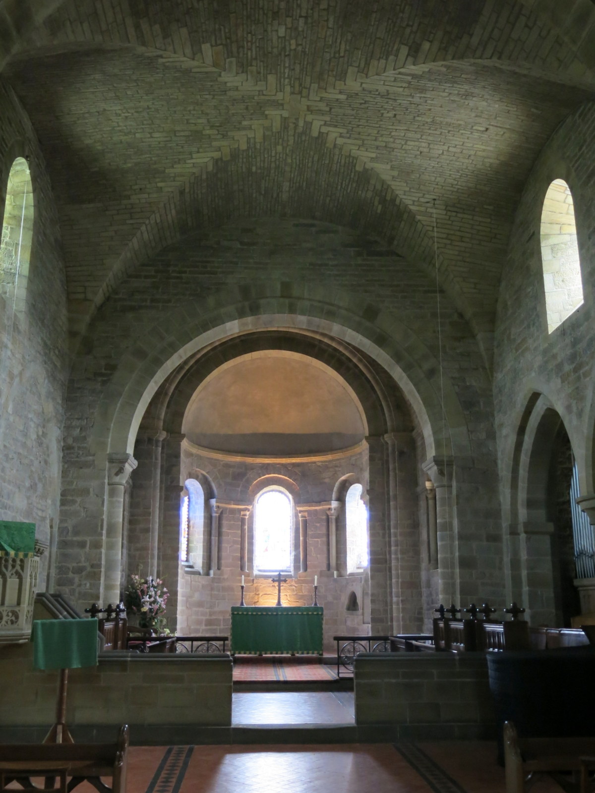
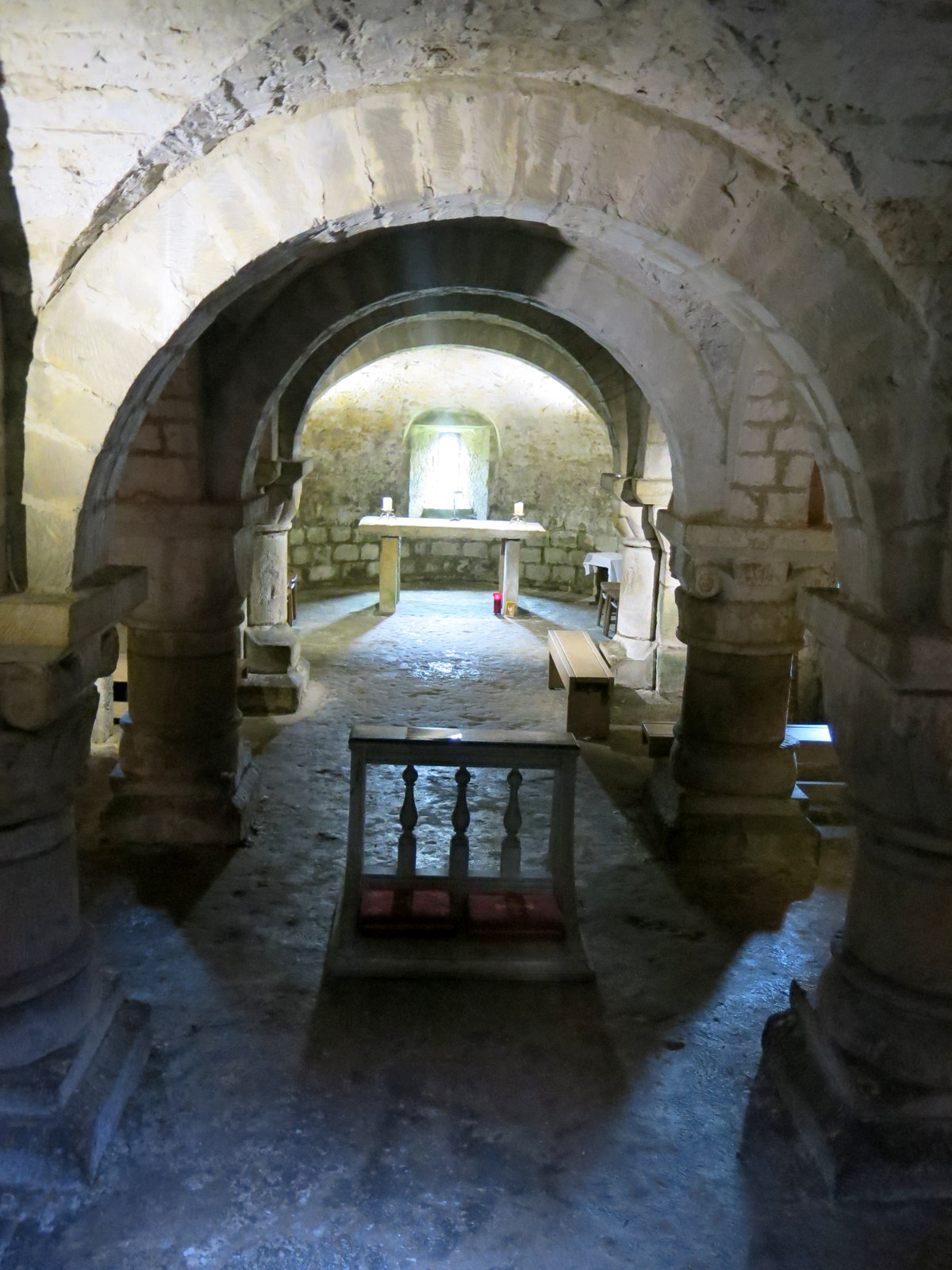
St Mary's Church was open and we entered to have a look around. A notice explained that it has an early Norman crypt constructed in1078, unique in English churches, and we descended the stairs to explore it. The crypt was constructed as the original intention had been to build an abbey here, on the site of a 7th century monastery.
 |
| 1701 Here lieth the body of Ann Burton |
 |
| Looking towards the altar |
 |
| The crypt |
 |
| Part of a Saxon cross |
 |
| The original top of Ana Cross (see below) |
 |
| Clive soaks up the atmosphere |
We enjoyed poking about in the old church, all the more so as we had the place to ourselves. We went up into the main church and walked round admiring the stained glass windows before exiting and making our way back to our route, passing an interesting ancient well on the way.
 |
| St Mary's Church |
 |
| Hear (sic) lies the body of John Burton Interd (interred) Decembr 1st 1755 |
 |
| St Cedd's well |
We turned left at a road junction and left the village, our tarmac road became a track and then entered the open moor.
 |
| Leaving Lastingham, we walk up to the open moor |
 |
| Looking back from the moor to St Mary's Church |
Our walk now became a trudge across the open moor, the only thing of interest being the masses of flowering heather which gave off a strong smell of pollen in the brisk north wind. After a couple of miles we could make out the Ana Cross standing above the horizon, and turned left at a fork to reach it. The cross was rebuilt in the last century and we had seen parts of the original in St Mary's Church crypt. At 12 feet it's the highest cross on the moors but the original was believed to be twice that height.
 |
| The Ana Cross |
 |
| At 12' the Ana Cross is the highest on the North York Moors |
 |
| We leave our coffee spot to return to the cross and our path |
The plinth of the Ana Cross would have made an ideal seat for a refreshment stop but the biting wind made us look for shelter. Nearby we found a gully where walkers in similar circumstances had obviously dragged a couple of flat stones for seats and we hunkered down to enjoy our scones and coffee out of the wind.
Returning to our path we headed further north until we reached the Rosedale road and Chimney Bank. Our path turned left here but we decided to walk to the right to get a view down into Rosedale.
 |
| Rosedale appears in the distance |
 |
| We leave our route to walk towards Rosedale's bank top |
 |
| Rosedale |
 |
| Sign at Bank Top |
 |
| The ruins of the iron ore kilns |
 |
| Walking towards the kilns |
After admiring the view of Rosedale and the remains of the iron ore kilns we returned to our route and walked along the tarmac road for half a mile. At a green metal footpath sign we turned right off the road and followed a moor track for about three and a half miles, as before, the beautiful sight and smell of the heather stopped this from being a route march.
 |
| Our path across the moor |
We noticed what appeared to be a wooden box about 20 yards from the track and went over to find an unusual trap. It had a small circular entrance that would only allow a rat, weasel or stoat sized animal to enter to get the bait and on opening the top we could see a small gin trap and the remains of some poor creature. Obviously the remains were old and we wondered why such a fancy trap had been abandoned by its owner.
 |
| Clive opens the trap |
 |
| Grisly remains |
 |
| A solitary pine amongst the heather |
Eventually we could see the roofs of Hutton-le-Hole below us and we walked back to our car and a well earned pint in the Crown Hotel.
 |
| Approaching Hutton-le-Hole |