Tripsdale to Bransdale from Chop Gate
12.5 miles Sunny
Leaving the Community Centre we walked south along the B1257 until we saw a footpath sign indicating William Beck Farm where we turned off the road.
A straight walk along the farm track brought us to William Beck Farm, long established, according to TSB, who informs us that in 1160 it was named Willelmesbec.
Just past the farm we saw a dead sheep next to the wall with its lamb standing forlornly nearby so Clive went to find help. He returned with the farmer who told us he was grateful for the information. While the sheep are lambing they check the fields up to five times a day, he told us. He and another worker drove off in a quad vehicle to recover the dead animal.
Leaving the drama at the farm we climbed steeply to the moor gate. Pressing on we soon dropped down Black Intake into the uninhabited and hidden dale of Tripsdale. Tom Scott Burns tells us in his guide that on the 12th February 1943, during World War 2, a Wellington Bomber returning to Croft after being hit over Holland crashed on Black Intake, killing all six crew. Bits of wire and metal are still to be seen scattered in the heather.
We walked back towards the bulldozed shooters' track passing the ruins of a dwelling which TSB explains was the home of an old cobbler who used to sell clogs and shoes outside the Fox and Hounds Inn at Seave Green on Sundays, as the congregation came down from Urra Church. There were numerous traps set around this building but nothing had been caught.
We climbed out of Tripsdale onto Hagg Moor, a 'hagg' being a wood or coppice grown on broken ground, and then crossed Todd Intake Moor. After walking for about a mile we came to two huts on the right hand side. In the mid-90s I took shelter in one of these huts in a storm and found Tom Scott Burns had left leaflets on the table, advertising his Walker's Guides, intended to be picked up by passing hikers. Nothing so interesting today however, but we decided it was time for a coffee as we had been walking for a couple of hours.
It's a couple of years since we last did this longer walk from Tom Scott Burns book The Walker's Guide to the Cleveland Hills.
We left Middlesbrough in a North Sea fret but as we drove past Clay Bank the sun came out and stayed with us all day. We later learned that Middlesbrough had remained in murk confirming the old adage 'the sun shines on the righteous'.
We parked at the free car park in the Community Centre at Chop Gate.
 |
| Today's walk from The Walker's Guide to the Cleveland Hills |
 |
| Chop Gate Community Centre |
Leaving the Community Centre we walked south along the B1257 until we saw a footpath sign indicating William Beck Farm where we turned off the road.
A straight walk along the farm track brought us to William Beck Farm, long established, according to TSB, who informs us that in 1160 it was named Willelmesbec.
 |
| Leaving the B1257 at the farm entrance |
 |
| William Beck Farm |
 |
| Stone Badger at William Beck Farm |
 |
| Bull weather vane at William Beck Farm |
 |
| Free range peacocks at William Beck |
Just past the farm we saw a dead sheep next to the wall with its lamb standing forlornly nearby so Clive went to find help. He returned with the farmer who told us he was grateful for the information. While the sheep are lambing they check the fields up to five times a day, he told us. He and another worker drove off in a quad vehicle to recover the dead animal.
 |
| Farmer returns with Clive |
 |
| Off to recover the body |
 |
| Curious sheep rush over to see what's going on |
 |
| Dead sheep and live lamb placed in quad |
Leaving the drama at the farm we climbed steeply to the moor gate. Pressing on we soon dropped down Black Intake into the uninhabited and hidden dale of Tripsdale. Tom Scott Burns tells us in his guide that on the 12th February 1943, during World War 2, a Wellington Bomber returning to Croft after being hit over Holland crashed on Black Intake, killing all six crew. Bits of wire and metal are still to be seen scattered in the heather.
Ahead of us we could see the ugly scar of the shooters' track up the other side of Tripsdale heading towards Bransdale but first we thought we would divert to look at the Ship Stone, so called because the front of the stone looks like the prow of a ship. We reached the beck and turned right for a hundred yards or so and found the Ship Stone which looks insignificant as one approaches from its rear but is enormous from the other side. On the stone is a Latin inscription which translates as "All things are full of the Creator. John Hart, a man of Bilsdale 1849".
 |
| Climbing to the moor gate |
 |
| Looking over to the murky weather at Middlesbrough |
 |
| We nearly stood on this chap, his family was better hidden |
 |
| Descending into Tripsdale |
 |
| Taking a moment in the shade |
 |
| Looking upstream at Tripsdale |
 |
| We follow the stream to reach.... |
 |
| ... The Ship Stone |
 |
| "All things are full of the Creator. John Hart, a man of Bilsdale 1849" |
 |
| I admire the inscription |
 |
| Ruins of the Cobbler's Hut |
 |
| Shooter's huts |
 |
| They are unlocked and reasonably clean.. |
 |
| A coffee out of the wind |
 |
| The bleak view from the huts |
We continued along the moor track for another mile or so and came to the remains of Stump Cross and, just after, the almost hidden turn off to Bransdale. It is important to note that as soon as you come to Stump Cross you should look to the left for a small cairn. The side path we needed was almost invisible at first but there were more reassuring cairns every hundred yards or so proving it wasn't just a sheep track. We soon came to a fine view down into Bransdale.
The track led us down into Bransdale, crossing a small road, and to Colt House Farm, which is marked as Bransdale Castle on old maps. From the farm we followed way marks across several fields and descended to reach an old sun dial above Bransdale Mill.
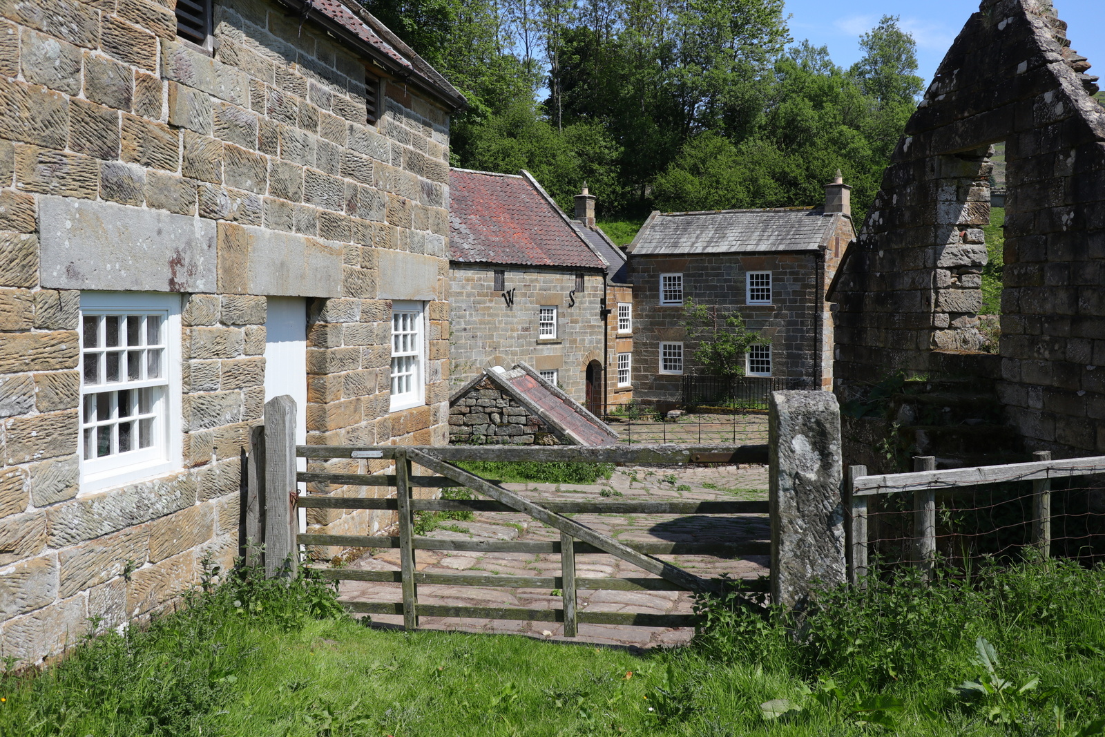
We walked another hundred yards to reach the old mill where we found a nicely placed bench, just the spot for coffee and scones in the sun.
The old mill, which we believe to be owned by the National Trust, appeared deserted today. On the front of the building was an inscription stating that it had been rebuilt in 1842 and the wall ties 'W' and 'S' stand for William Strickland who rebuilt the mill after moving from Farndale. Round the back we saw a Greek inscription which was apparently the work of Strickland's son, who became curate at Ingleby Greenhow and is responsible for a number of inscriptions in the area. TSB says that this one means, "Rejoice evermore Pray without ceasing. In everything give thanks."
Break over, we began a steep climb out of the dale which brought us first to Cow Sike Farm and then past a conifer plantation to join the ancient roadway of Rudland Rigg. This runs from Kirby Moorside to Turkey Nab above Ingleby Greenhow. Here we were buzzed by two low flying helicopters, almost certainly military as they had missile pods.

Marching along Rudland Rigg we came to a large standing stone which TSB says was 'erected by primitive hands'. This is known as the Cammon Stone, derived from the celtic 'cam' meaning 'bank stone'. On the front is a Hebrew inscription which translates as "Hallelujah", almost certainly the work of Emmanuel Strickland from Bransdale Mill.
Rudland Rigg took us to the old Rosedale Railway track at Bloworth Crossing and the Cleveland Way. We left the railway shortly after, heading west to Botton Head, the highest point of the North Yorkshire Moors, at 1500 feet. Here we left the Cleveland Way and headed westwards across Urra Moor, dropping off the edge to descend a lovely moor lane to Bilsdale Hall.

We passed through Seave Green and then joined the B1257 for a walk along the pavement, back to Chop Gate. We were delighted to find The Buck Inn open and spent a happy half hour sitting outside in the evening sun before returning to the village hall and the car.
 |
| Stump Cross |
 |
| Clive spots the small cairn |
 |
| Once on the track we come to a cairn every hundred yards or so |
 |
| Bransdale appears |
 |
| We start the descent |
 |
| We pause to allow cattle to cross our path over the next field |
 |
| Bransdale Lodge above us |
 |
| Sun dial |
 |
| Time and Life move swiftly |
We walked another hundred yards to reach the old mill where we found a nicely placed bench, just the spot for coffee and scones in the sun.
 |
| Bransdale Mill |
 |
| A good spot for lunch |
 |
| Rebuilt 1842 |
 |
| Greek and Hebrew inscription |
The old mill, which we believe to be owned by the National Trust, appeared deserted today. On the front of the building was an inscription stating that it had been rebuilt in 1842 and the wall ties 'W' and 'S' stand for William Strickland who rebuilt the mill after moving from Farndale. Round the back we saw a Greek inscription which was apparently the work of Strickland's son, who became curate at Ingleby Greenhow and is responsible for a number of inscriptions in the area. TSB says that this one means, "Rejoice evermore Pray without ceasing. In everything give thanks."
Break over, we began a steep climb out of the dale which brought us first to Cow Sike Farm and then past a conifer plantation to join the ancient roadway of Rudland Rigg. This runs from Kirby Moorside to Turkey Nab above Ingleby Greenhow. Here we were buzzed by two low flying helicopters, almost certainly military as they had missile pods.
 |
| Looking back at the mill as we begin the climb |
 |
| Blue Thunder! |

Marching along Rudland Rigg we came to a large standing stone which TSB says was 'erected by primitive hands'. This is known as the Cammon Stone, derived from the celtic 'cam' meaning 'bank stone'. On the front is a Hebrew inscription which translates as "Hallelujah", almost certainly the work of Emmanuel Strickland from Bransdale Mill.
 |
| St Nicholas' Church - too far away for a visit |
 |
| A steep climb |
 |
| Walking along Rudland Rigg |
 |
| The Cammon Stone - front |
 |
| The rear of the Cammon Stone |
Rudland Rigg took us to the old Rosedale Railway track at Bloworth Crossing and the Cleveland Way. We left the railway shortly after, heading west to Botton Head, the highest point of the North Yorkshire Moors, at 1500 feet. Here we left the Cleveland Way and headed westwards across Urra Moor, dropping off the edge to descend a lovely moor lane to Bilsdale Hall.
 |
| A last look back at Bransdale |
 |
| We pass a large group of walkers, perhaps Coast to Coasters |
 |
| We turn off here towards Bloworth Crossing |

 |
| Trig Point is the highest point on the North York Moors at 1454' |
 |
| Approaching the descent to Seave Green |
 |
| Looking down into Bilsdale |
We passed through Seave Green and then joined the B1257 for a walk along the pavement, back to Chop Gate. We were delighted to find The Buck Inn open and spent a happy half hour sitting outside in the evening sun before returning to the village hall and the car.
 |
| Down to Seave Green |
 |
| A curlew passes overhead |
 |
| Bluebells in Seave Green |
 |
| Ooh, it's open! |
 |
| To short walks and long drinks! |