Along the Old Drovers' Road from Osmotherley
7 miles Cold and windy
A few years ago we could drive in to Osmotherley and park outside the old Thompson's shop without problem but nowadays such is the village's popularity we need to drive around the village searching for a newly vacated spot. Eventually we found one, booted up and set off past the Market Cross into Quarry Lane.
 |
| Today's walk from The Walker's Guide to the Cleveland Hills |
 |
| Osmotherley |
 |
| Thompson's Shop, est.1786 but now falling into ruin |
 |
| The Queen Catherine - now closed during the week! |
 |
| One of my favourite weather vanes is in Osmotherley |
In the Domesday Book Osmotherley is known as Asmundrelac, which means 'Asmund's clearing'. We would walk past a cottage bearing this name on our return.
Tom Scott Burns explains in his notes for the walk that the village was ravaged by William the Conqueror in 1069 and was still described as waste land in its entry in the Domesday Book in 1085.
He also relates that the village was raided by the Scots on several occasions and a raid in 1315 was so severe that the village was excused all taxation because of the distress it had suffered. A few years later, in 1348, the Black Death carried off nearly half the population of Osmotherley.
We walked up Quarry Lane from the market cross and after passing a restored Pinfold we turned into Ruebury Lane and began to climb.
 |
| Walking up Quarry Lane |
 |
| Pinfold - where stray animals were held until payment of a fine |
 |
| Inside the old pinfold |
 |
| Stately Ruebury House is on the corner of Ruebury Lane |
 |
| Follow the Cleveland Way sign |
 |
| A memorial on Ruebury Lane |
 |
| Viewpoint from the memorial stone |
We quickly gained height until we looked back down on Osmotherley. A little further, when the lane becomes a track, is the Lady Chapel founded by Queen Catherine of Aragon in 1515. It is still a religious retreat and we followed the twelve stations of the cross as we approached it.
 |
| The First Station of the Cross |
 |
| Climbing towards.. |
 |
| Lady Chapel |
 |
Lady Chapel
|
Last time we passed this way we found Lady Chapel unlocked and looked inside.
 |
| Inside Lady Chapel |
 |
| Clive admires the chapel |
 |
| Explanation for the shields on the West window |
Leaving the Lady Chapel we dropped down to a track where we turned right, still following the Cleveland Way. This track has a fine view over the Vale of York and we walked along picking out landmarks such as The Tontine on the A19 below.
 |
| Leaving Lady Chapel |
 |
| New gates and signs for the Cleveland Way |
 |
| "I can see your house from here" |
We followed the Cleveland Way along the ridge of Summer Game Hill and Swinestye Hill throught he trees of South Wood.
 |
| This sign used to cause confusion to C2C walkers until the little plaque was added |
 |
| South Wood |
We walked uphill through the birch trees of South Wood to reach transmitter masts at Beacon Hill. The track continues straight past the masts and directly onwards until reaching the gate to Scarth Wood Moor. We followed the Cleveland Way path across Scarth Wood Moor, all the time enjoying a fine prospect towards the Cleveland Hills, and in the foreground, Whorl Hill.
 |
| The wall last year |
 |
| Arncliffe Wood has been cleared and the unwanted wood left in piles |
 |
| Entering Scarth Wood Moor |
 |
| Crossing the moor, Whorl Hill to the left |
Eventually we reached a wooden sign at the deep trough of Scarth Nick, pointing towards Cod Beck Reservoir, and left the Cleveland Way to soon join a tarmac road that runs from Swainby to Sheepwash.
 |
| We leave the Cleveland Way |
 |
| Swainby below |
 |
| We also leave the Lyke Wake Walk |
 |
| Scarth Nick |
We now walked into a bitter head wind through Scarth Nick to reach Sheepwash. TSB explains that during the Ice Age of approximately 20,000 years ago, a glacier from the north enveloped an area 20 - 30 miles wide and 1,000 or more feet thick. It failed to cover the moors but crept into Scugdale depositing materials from Scotland, Cumbria and Durham. Sand, gravel and stones left by meltwater formed the conspicuous mound of Round Hill, the present car park at Sheepwash.
Reaching the water splash at Sheepwash we crossed the bridge and sat on Crabdale Beck's stony bank, sheltered from the wind, to enjoy our coffee and scones.
 |
| Walking through Scarth Nick |
 |
| We join the Swainby to Osmotherley road |
 |
| ... and reach Crabdale Beck |
 |
| Scones al fresco |
Crabdale Beck was a nice sheltered spot and after enjoying our coffee and scones we headed uphill towards Pamperdale Moor and a head wind.
We now walked along High Lane alongside the forestry plantation above Cod Beck Reservoir. This was once a Drovers' Road and TSB suggests that it was probably used by prehistoric man, the Romans and before the present day road was made, as a corridor through the Cleveland Hills.
 |
| Our view with coffee |
 |
| Climbing from Crabdale Beck to Pamperdale Moor |
 |
| High Lane, the old Drovers' road |
 |
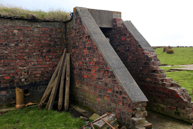
| At the end of the plantation look out for the Starfish on the left! |
As we reached the end of the plantation we saw an unusual brick building which we have previously investigated and found to be a WWII Starfish, one of five such sites built during the last war to protect industry at Teesside by the following means:
A series of iron tanks, raised on gantries, would be set out. These tanks held inflammable liquid that could be ignited and quenched on demand. The fires were lit as soon as German bombers began an attack. When they were quenched, the resulting steam looked like the smoke of a burning city, and enemy pilots would drop their bombs harmlessly on the moors instead. Such decoys were officially known as ‘SF’ or ‘Special Fire’ locations, but were generally called ‘Starfish’ sites.
 |
| The Starfish, seen from High Lane |
 |
| Concrete base nearby - were the tanks set out here? |
The bricks of the starfish are very similar to those in the pillars near the transmitter station.
We continued along High Lane and as we reached the tarmac road from Osmotherley we passed the ruins of Solomon's Temple, which was built by the eccentric Solomon Metcalf in 1812 and had images of the sun, moon and stars on its walls. Now only fallen stones mark the spot.
 |
| Now on tarmac |
 |
| .. we pass the ruins of Solomon's Temple |
Shortly afterwards we reached Chequers Farm. This interesting building was an old inn and held a licence for 300 years until 1945. When it was a hostelry it was famous for keeping an old peat fire alight for 150 years! The sign of the Inn was a chequers board and TSB says this was derived from the chequers that were handed to the drovers to be exchanged for refreshment at the inn. The sign bore the cryptic message "Be not in haste, Step in and taste, Ale tomorrow for nothing." Of course as we all know tomorrow never comes. The old sign has been mounted behind glass on the farm wall.
The building has been repainted and was featured in a recent Christmas edition of Paul Whitehouse and Bob Mortimer's fishing show, when the duo used it as their base for the TV programme.