TSB refers to Scugdale as 'the sheltered dale' from the Danish skygger - to overshadow.
We descended across a couple of fields to reach the dale road where we turned left to walk towards the top of the valley and High House. Cattle have been turned out to graze freely in the north of the dale and the dales road has suffered consequently, as have all parts of the valley down to Scugdale Beck which has formed a barrier to them.
 |
| Scugdale Hall |
 |
| Barker's Crags |
 |
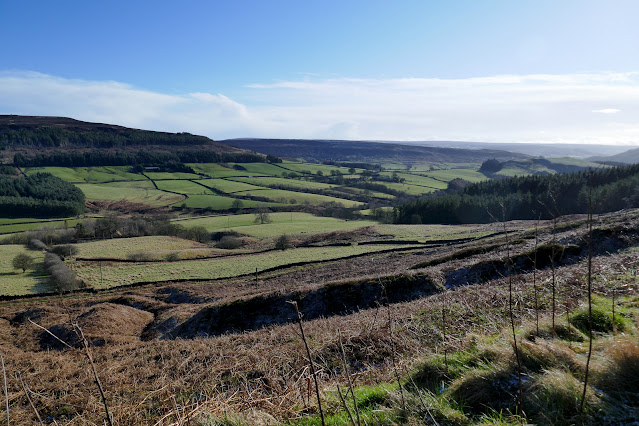
| Looking across Scugdale |
 |
| Go right through the new gate.. |
 |
| ... and follow the track to reach.. |
 |
| .. the dale road |
 |
| Hardy cattle have free rein in Scugdale |
 |
The remains of jet mining
|
As we walked towards High House we looked at the hillside to our right and saw the light snow had emphasised the spoil remains of jet mining. After jet jewellery became fashionable in Victorian times Bilsdale, Raisdale and Scugdale were mined heavily. Mining was a simple affair, the miners tunnelled into the hillside and the shale was brought out and examined for jet. The spoil was then tipped down the hillside leaving the long piles of rubble seen above. An interesting article here provides more information about mining in the area.
We followed the dales road south to reach High House. TSB records that in this old farmhouse lived Harry Cooper who was reputed to be the tallest man in the world, standing at 8'6". He left Scugdale to join Barnum's Circus in America and died in 1898 at the age of 41.
The house is currently unoccupied and its outbuildings are falling into ruin.
 |
| Approaching High House |
 |
| A sad sight |
 |
| High House |
 |
| The outbuildings are in a perilous state |
Just beyond the house we turned right off the lane into fields at a dilapidated stile. This part of the walk appears untrodden but there a are a few guiding way marks at field boundaries and we descended to reach and cross Scugdale Beck where we found (as on our previous visits) the old bridge continues to serve no useful purpose, having been displaced by winter storms some years ago.
 |
| Cross with care! |
 |
| Scugdale from High House |
 |
| Approaching Scugdale Beck |
 |
| No paths so aim for the trees and look for signs |
 |
| This one's no use |
 |
| We spot the old bridge through the trees |
 |
| But you must cross the beck to reach the bridge! |
 |
| Beached for many years now |
After crossing the beck we climbed up the steep bank to join a faint path that takes one north along Scugdale, walking under the old jet and alum workings.
As we approached Holiday House we stopped in a sheltered spot to enjoy our coffee and scones with a fine view across Scugdale. As we did so a stoat with white winter coat ran down the hill less than twenty feet away. My fumbles for my camera were in vain.
 |
| Climbing up from Scugdale Beck |
 |
| Follow the sign straight down Scugdale |
 |
| Barker's Crags, Scugdale Hall and its outbuildings across the valley |
 |
| Stiles and two bridges before Holiday House are very slippery |
 |
| A sheltered spot |
After our break we walked past Holiday House and met a hiker coming our way. "I've just seen a white stoat!" he said, and we wondered if it was the same one we had seen ten minutes earlier.
 |
| This jury rigged stile rocks alarmlingly when crossed |
 |
| Scugdale Hall |
 |
| Approaching Holiday House |
 |
| Holiday House |
Holiday House is a strange name and the farm was so named on a 1940s map that I have seen. I would be interested to know the origin of its name.
We followed the farm track down and on reaching the dale lane turned left and walked north for a mile or so, until we reached the buildings of Fog Close Farm.
This is the most difficult part of the walk as there are no waymarks until you have actually passed the farm. So, from the dale lane go through the farm gate for Fog Close, then right again to walk past the farm buildings. Just past the farm take a left and head up towards the fence line where finally there is a waymark to be seen on a gate. This area is all freely grazed by cattle and the right of way is very difficult in places with deep slurry.
 |
| Walking north along the dale lane |
 |
| Through the farm gate |
 |
| Hardy cattle at Fog Close Farm |
 |
| Snotterdale from Fog Close Farm |
 |
| Through the unmarked gate and right in front of farm buildings |
 |
| Then left through the gate |
 |
| A waymark at last |
We walked up to a path running under Live Moor, which we followed with fine views into charmingly named Snotterdale, a quiet and uninhabited valley.
 |
| Snotterdale ahead and Scugdale to the right |
 |
| Our path under Live Moor |
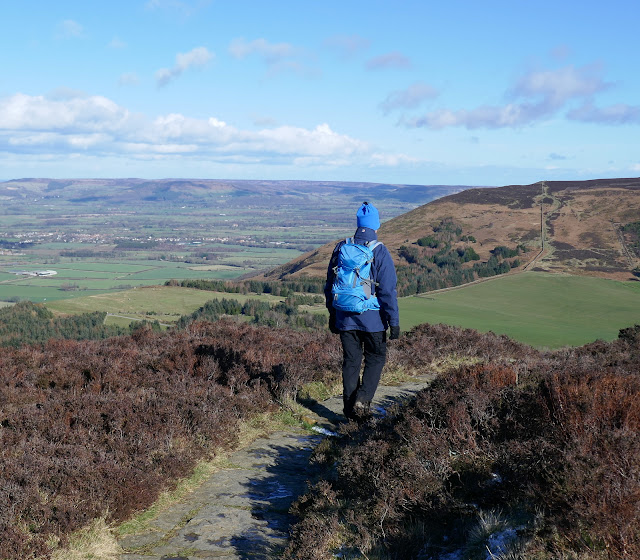
Opposite a conifer plantation the path turns left across Carlton Moor at a rocky outcrop. We passed over the old glider station runway and reached the Cleveland Way/Coast to Coast path that follows the ridge with spectacular views all the way to a trig point at 1338 feet.
Immediately after the trig point we started the steep descent to the road and the car park at the Lord Stones Cafe.
Carlton and the Blackwell Ox pub were just down the road and we were soon discussing this interesting walk that takes in one of our favourite dales over a well-earned pint.
 |
| "Whose round is it again..?" |