Exploring Scugdale from Carlton Bank
7 miles Cold and misty
It is 2.5 years since I last blogged this walk. How time flies and this is a good walk and certainly worth revisiting even though today's weather forecast is poor.
Today was my birthday and for the first time in five years I forgot to pack my camera. I hope this is not a sign of advancing years. This necessitated that today's photos be taken with my phone so please excuse their quality.
We drove up Carlton Bank to the Lord Stones Cafe and parked in their car park, knowing that we would repay their hospitality on our return.
 |
| Today's walk from The Walker's Guide to the Cleveland Hills |
 |
| Lord Stones Cafe |
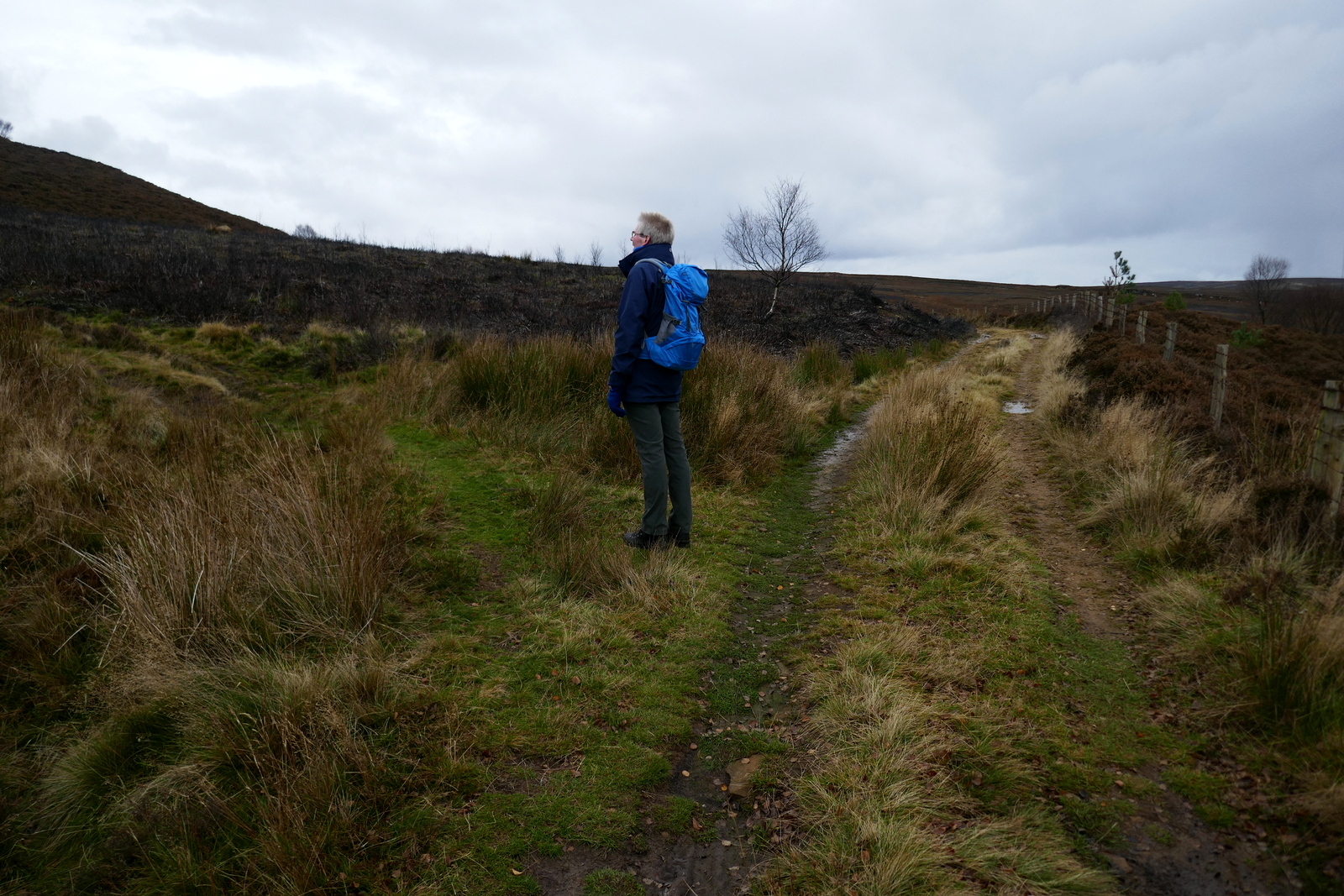
We walked back along the Carlton road until we reached a new Cleveland Way sign, and turned left off the road to follow it uphill. Almost immediately we turned right from the Cleveland Way and followed the wide access road for the old Gliding Club (now demolished) steadily uphill. We should have had views over the Cleveland Hills towards Roseberry Topping but visibility was poor with low cloud and a fine drizzle.
 |
| Turn off the Carlton road at this Cleveland Way sign |
 |
| Turn off the main track at the footpath sign |
 |
| Passing Stone Ruck |
Reaching the moor top we turned left off the access road where a footpath sign indicated our track across the heather. The first feature one comes to on this path is the rocky outcrop of Stone Ruck. Tom Scott Burns explains that Ruck is derived from the Old Norse bruga meaning 'to pile or heap up', as in a cairn.
 |
| Bleak moors path |
We followed the path for a mile or so across the moor until we came to Brian's Pond which looked dark and uninviting today. There was no sign of life so we continued on our way climbing steadily over Clough Gill Top, where a signpost indicates a choice of routes.
 |
| Brian's Pond (north end) We'd like to know the origin of the name, nothing found online. |
 |
| Brian's Pond (south end) |
 |
| Turn right |
We took the right fork that ascends steadily to the moor rim where we suddenly came upon the valley of Scugdale. To our right were the rocks of Barker's Crags and below us the buildings of Scugdale Hall.
 |
| Scugdale comes into view |
 |
| Barker's Crags |
 |
| Looking down into Scugdale |
TSB refers to Scugdale as 'the sheltered dale' from the Danish skygger - to overshadow.
We descended across a couple of fields to reach the dale road where we turned left to walk towards the top of the valley and High House. Over the years the dales road has been strengthened with stones, tarmac, pottery and bricks and we found several old bricks embedded in the lane bearing the name Old Linthorpe. A google search shows that these bricks were manufactured by a George Grubb Dalton, Brick Manufacturer, Builder & Contractor, Linthorpe, Middlesbrough, who is recorded in the London Gazette as giving Notice of Intended Dividends on the 13th November 1888.
 |
| Walking down to the Dales road |
 |
| Old Linthorpe brick |
We followed the dales road south to reach High House. TSB records that in this old farmhouse lived Harry Cooper who was reputed to be the tallest man in the world, standing at 8'6". He left Scugdale to join Barnum's Circus in America and died in 1898 at the age of 41.
The house is currently unoccupied and its outbuildings falling into ruin. Just beyond the house we turned right off the lane into fields at a dilapidated stile. This part of the walk appears untrodden but there are guiding way-marks at field boundaries and we descended to reach and cross Scugdale Beck where we found (as on our previous visit) the old bridge that continues to serve no useful purpose, having been displaced by winter storms some years ago.
 |
| High House |
 |
| Dilapidated stile |
 |
| Head down towards the trees and beck |
 |
| Scugdale Beck |
 |
| Unfortunately you have to cross the stream to reach the bridge! |
We crossed the beck and climbed up a steep bank to join the faint path that took us down the valley, walking under old alum workings. When we reached some grassy banks just before Holiday House we stopped and enjoyed our coffee and scones looking across at Scugdale Hall.
 |
| Approaching Holiday House |
 |
| Scugdale Hall through the mist. From our coffee stop |
After enjoying our coffee and scones we set off once more and almost immediately came upon a young black sheep, pressed against the fence and looking very sorry for itself. It was covered in brambles which had wrapped around its haunches and back end so that any movement must have been very painful. Clive spent ten minutes carefully removing the thorns and then as an treat, gave the grateful sheep an apple which it ate very gingerly, apparently having made its mouth sore pulling at the brambles.
 |
| Clive starts at the top.. |
 |
| .. and works his way along the sheep |
 |
| The brambles had penetrated its wool |
 |
| Ooh that's better..! |
 |
| Enjoying an apple and looking much happier |
Passing Holiday House we followed its long access track to the dale road, where we turned left and walked for a mile or so to reach the farm buildings of Fog Close. Here we turned right into the farm's track at a footpath sign, and then right again before reaching the farm buildings, before turning left and walking up the side of the farm towards Live Moor.
 |
| Holiday House |
 |
| Sheepdogs at Holiday House |
 |
| Crow or magpie totem at Holiday House near game feeders |
 |
| Back on the dale road.. |
 |
| ... to reach Fog House Farm |
After a steep climb to reach Live Moor we followed the escarpment with a misty view down into the charmingly named and little known valley of Snotterdale, to which there is no road or path access.
 |
| Along the ridge of Live Moor |
 |
| Snotterdale |
 |
| Looking back to Scugdale |
Opposite a conifer plantation the path turns left across Carlton Moor where we were soon walking on the old gliding station runway, before crossing to join the Cleveland Way/Coast to Coast walk that follows the ridge with spectacular views all the way to a trig point at 1338 feet.
 |
| The mist comes down and the rain starts on the old glider runway |
 |
| Passing a weather station on the Cleveland Way footpath |
 |
| No views today but this was our view last time, from the Cleveland Way |
 |
| We reach the trig point and a standing stone on Carlton Moor |
 |
| Starting to descend... |
 |
| .. and visibility improves slightly as we approach Lord Stones Cafe |
From here we took the steep and stony path down to the road and then to the Lord Stones Cafe where we cheerfully repaid our parking debt by purchasing a couple of pints of Black Sheep Ale.
 |
| 'It doesn't have to be fun to be fun!' |