"There must be dales in Paradise
Which you and I will find.."

Friday 24 February 2017


Kilburn White Horse Circular Walk


   5.5 miles               Storm Doris


An apocalyptic weather forecast made us decide on a shorter walk as we couldn't change days for (my) domestic reasons.  

For this walk Tom Scott Burns suggests parking at the pay and display car park at the information centre but there is a free car park just below the White Horse and we feel this gives a better balance to the walk, with Gormire being reached at the half way point.


Today's walk from the Walker's Guide to the Hambleton Hills

The White Horse at Kilburn from Low Town Bank Road

The White Horse from our car park


From the car park we crossed the road and joined a track that followed the road steeply downhill.  Where the track rejoined the road at the bottom of the hill we crossed over and went through a gate where there was a footpath sign.


Down hill parallel to the road

Turn right through the gate


We followed this farm track through the charmingly named forestry plantation of Happy Valley with nice views up to the cliffs of Roulston Scar to our right.  


Lots of snowdrops in today's walk

Unusual stile


Roulston Scar from Happy Valley


The rain came and went in flurries, sometimes very heavy and sometimes just drizzle, and eventually we came to a stile and way mark on our right.  We crossed over into fields which were slippery with mud and headed towards Hood Farm, directly ahead.

The buildings of Hood Farm were surrounded by deep mud and here we had a problem getting through, without sinking knee deep.  We were relieved to reach the tarmac of the farm road which we followed to the A170.


Leaving the woods

Across the fields to Hood Farm

Hood Farm

We need to get through the gate on the left

Secure cockerels at Hood Farm


As we walked along the farm track we saw a neatly tended grave and next to it a smaller plot, marked with a horseshoe, which we presume must belong to a much missed pet.


Two Southdown 'teddy bear sheep' stand out from the crowd

Unusual sheep at Hood Farm

The grave at Hood Farm


The A170 was busy as always and we walked along it for a hundred yards or so to the entrance to High Cleaves Farm, but almost immediately turned right into a field track to the little valley of Butter Dale, which TSB says was cut by last the Ice Age.

High Cleaves Farm ahead

Turn off before the farm across fields

Butter Dale


Following the footpath over a stile a sharp climb took us to the first lake, at Gormire Rigg.  At the end of this lake we turned right and soon reached the waters of Gormire.

We followed the lake round its southern shore and came to a perfectly placed bench made from railway sleepers, an ideal spot for coffee and scones.  The rain had stopped and we sat out of the wind in this peaceful place with silence broken only by the occasional honk from some Canada Geese.  Because of its difficult location we rarely see anyone here and today, probably because of the threat of bad weather, we didn't see anyone throughout the whole walk.

Gormire Rigg

Walking alongside Gormire Rigg Lake


Masses of snowdrops

Stones from an ancient building


Gormire is an interesting spot and I explain a little of its history in last month's walk from Boltby  but eventually the coffee ran out and it was time to gird our loins for the long and very steep climb to the top of Whitestone Cliff.


Our first glimpse of Gormire


A convenient bench

Scontentment

A peaceful scene

After twenty minutes we reached the top and turned right on the path, signposted Sutton Bank.  We now had a fine ridge walk of about 1.5 miles along the top of the escarpment, all the while looking down into the Vale of Mowbray.  


Climbing ever upwards...

... to the top of Whitestone Cliff

Deposited by the ice?

Climbing through Garbutt Wood

Roulston Scar and Hood Hill

TSB explains in The Walker's Guide to the Hambleton Hills that during the last Ice Age glacial sheets, unable to override the Cleveland Hills, swept round both sides of the moors carving out the great cliffs at Gormire and Roulston Scar.  As we walked along the ridge the winds of Storm Doris steadily increased - fortunately blowing us away from the edge.  Opposite us we could see the cone shaped summit of Hood Hill where a number of barrows and earthworks are located around the summit.

We passed by the Information Centre and crossed the A170 again, continuing along the path which apparently was known as Thieves Highway in olden days.  This was because it was supposed to be a getaway route for robbers who had plundered travellers on the Hambleton road.


Ridge Walk

Re-crossing the A170


Sponsored sign at A170

Memorial stone on cliff top

Looking back towards Gormire...

.... and the other way to Roulston Scar


We walked past the Yorkshire Gliding Club and then past Roulston Scar to reach the top of the White Horse.  Our car lay below and we descended steps alongside the Horse to reach it.


Hood Farm below us

Yorkshire Gliding Club


Kilburn from Roulston Scar

We reach the top of the White Horse


Our car park from the White Horse

A short drive took us to Kilburn and The Foresters Arms. As we walked to the pub the heavens opened and Doris finally arrived.  We sat in front of the fire with a pint of John Smith's Cask Ale and congratulated ourselves on having a good walk and missing the worst of the weather.


Descending to the car park


Contented customer in the Foresters Arms

To Doris!


Friday 17 February 2017


Arden Great Moor Circular


10.5 miles         Cool and grey


We decided to do a longer walk from The Walker's Guide to the Hambleton Hills which Tom Scott Burns says can be started either at Arden Hall or Square Corner on the Osmotherley to Hawnby road.

We decided on the latter and set off to climb Black Hambleton in a sudden shower of rain which stopped as suddenly as it began.


Today's walk from The Walker's Guide to the Hambleton Hills

Setting off, Black Hambleton ahead


This sheep was not in mid-jump but remained balanced on top of the wall as we continued uphill

Looking down towards Kepwick

Once on Black Hambleton we walked along the drovers' road known as Hambleton Street, which we followed for about 2.5 miles from Square Corner until we reached the ruins of an old drovers' inn which was known as Limekiln House.

We have often wondered about the exact location of Limekiln House but that was answered today when we were surprised to see a new, gravestone-like, marker.  Close to the marker we saw that Bert's memorial had been uprooted so Clive replanted it.  We've often wondered whether Bert was man or beast, I don't suppose we'll ever know.

 
Bert's memorial uprooted

New marker stone


Clive restores Bert's memorial

We turned left off Hambleton Street at Limekiln House onto a grassy track, which we followed until we reached a gate where we had a surprise view down into the hidden valley of Thorodale.  A slippery mud path led us steeply down into the valley.


Starting the descent into Thorodale

Thorodale Valley

At the end of the valley I had a 'camera moment' when I discovered that my camera wouldn't take photos.  After several minutes of fiddling and cursing I discovered that I had knocked the setting onto 'effects' and after restoring it looked up to see Clive patiently leaning on a gate.


We followed our track through woods with brief glimpses of Thorodale Lake below.  As the track approached Arden Hall we found ourselves walking through masses of snowdrops which TSB suggests were probably planted by the nuns that occupied this site in the Benedictine nunnery of St Andrew, founded in 1148.  All that's left of the nunnery is an old chimney, now embodied into Arden Hall.

TSB says that the name Arden was probably derived from arn, an eagle, and doen, a deep valley - the valley of the eagle.


As we neared the hall we saw more and more little yellow flowers among the snowdrops.  These are winter aconites which are somewhat poisonous and also known as Wolfsbane.  TSB says these were also planted by the nuns.


Wolfsbane


In a secluded spot overlooking a stream we found a bench which we knew was dedicated to three hikers who were killed driving home from a hike in this area.  It is situated in a lovely sheltered spot and was ideal for our coffee stop.


Hikers R.I.P.


We finished our scones and coffee and walked up to Arden Hall, which would  make a good setting for  period drama, before retracing our steps and turning right into fields leading to Mount Pleasant Farm.


Approaching Arden Hall

The front of Arden Hall


Arden Hall


Fields leading to Mount Pleasant Farm

The sun comes out as we look down on Arden Hall, Dale Town Common behind

Coomb Hill from Mount Pleasant Farm

Mount Pleasant Farm

Cheeky sheep at Mount Pleasant


Walking up from the farm we passed the pretty cottage known as Harker Gates then into the woods of North Moor.  We could hear the sound of logging and soon came to the source of the noise.  We watched as a single machine fitted with hydraulic tools cut down trees, stripped the branches and sliced them into 12 foot lengths, the demolition of each tree taking only about 2 minutes.  Another tractor gathered up the lengths and another man loaded them onto  lorry.  Three men were clearing the forest at an amazing rate.


Harker Gates cottage

It took just a few seconds to cut the tree and trim the branches


Can you spot the Jack Russell terrier?


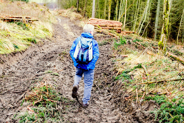
We walk through debris

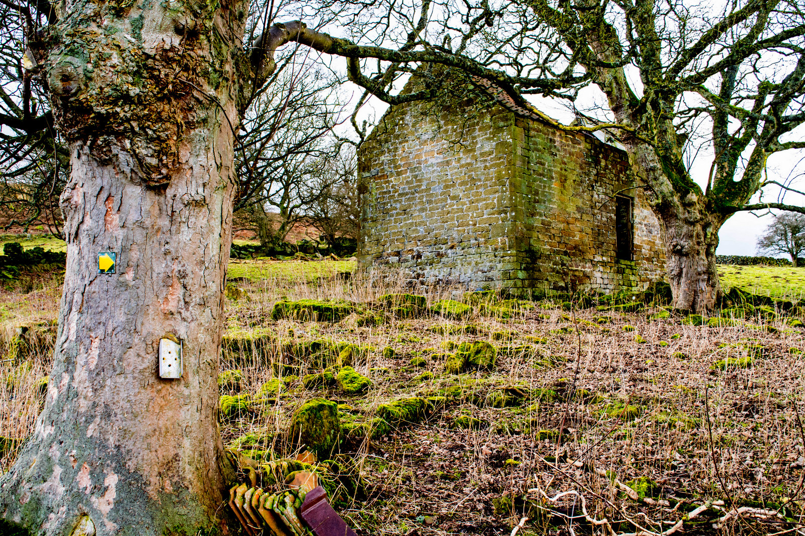
Our path took us past two ruined farms, Brewster Hill and Cow Wath and then across fields.  We were amused by a metal fox target, lying low on the hillside and showing signs of many bullets.


Brewster Hill farm ruin

Helpful way-mark as the path has disappeared at this point


Fox target


Cow Wath ruins

Passing the ruins of Far House our path ran parallel with the River Rye a hundred yards below .  We would shortly pass the source of the Rye at Dale Head.


Progress was slow on muddy paths as we passed by Low Locker Farm and over a large bridge at Dale Head.


Bridge at Dale Head

Just past Dale Head we saw our last ruined farm before walking across the heather of Low Locker Moor to join the Osmotherley to Hawnby road where we turned left to walk back down to the car.


Far House ruins


Locker Low Moor

'Cheerio'

We didn't reach the car until mid afternoon but fortunately the Queen Catherine at Osmotheley is open all day and we were soon discussing today's walk in front of a roaring fire.