7 miles Wintry showers
This is the most southerly outing in Tom Scott Burns' book 'The Walker's Guide to the Hambleton Hills', being four miles south of Helmsley. We drove to Nunnington via the B1257 Malton road and parked at the roadside, as shown on the map below, across the river from Nunnington Hall.
 |
Today's walk from The Walker's Guide to the Hambleton Hills
|
 |
| Nunnington Hall |
Tom Scott Burns explains that the name Nunnington is derived from the old English personal name Nunna rather than from the Saxon nunnery that once stood where the hall now stands.
We walked through the village admiring the neat streets, laid out in a grid formation with all the houses decorated in the same dark green and cream paintwork.
 |
| The Old School House at Nunnington |
 |
| Nunnington Village |
 |
| 'Percy' |
Walking here in 2017 we paused to admire the above weather vane at Nunnington Studios and were told that it was a memorial to a much loved dog, a spaniel called Percy. Apparently the spaniel was a real character who led a very independent life, doing exactly what he pleased. The weather vane of Percy was made to order and is life sized. At the other end of the village is a small copse of trees named after the dog, known as Percy's Plantation.
 |
| Once the village grocer, now a private house |
 |
| Bridge Cottage at the end of the High Street |
 |
| Leave the road at the bridge |
We continued through the village and left the road at a sign and began following the winding path of the River Rye. After about a mile we crossed a small bridge over a tributary and immediately turned left to follow a faint path through fields.
 |
| The River Rye |
 |
| We used the fence to negotiate this gate |
 |
| A peaceful walk along the river bank |
 |
| This bridge looks more risky each year! |
 |
| The river is almost blocked by debris |
 |
| Turn left away from the river |
We crossed a field and turned left again, into High Moor Lane which is actually a muddy track. We soon reached a tarmac road and turned left onto it, then after a hundred yards, right into fields. The field path took us straight across three or four meadows until we could see the roof-tops of Stonegrave below us.
 |
| We join High Moor Lane |
 |
| High Moor Lane |
 |
| Sheep in turnip field |
 |
| Turn right off tarmac... |
 |
| ... at this sign |
 |
| Soon descending to... |
 |
| ... the B1257 and Stonegrave |
We reached the busy B1257 at Stonegrave and walked through the village, bypassing our outward path to Caulkleys Bank on the left.
We turned right at the Elizabethan manor house to reach the Minster which was mentioned in an eighth century letter from Pope Paul to Eadbert, king of Northumbria.
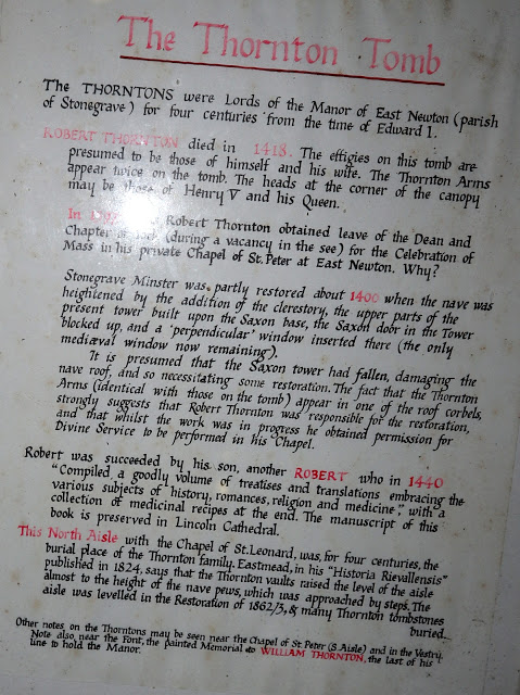
TSB says that Stonegrave is derived from 'steinn-gryfia' meaning a 'stone cleft', and there were important quarries providing building stone here in the Middle Ages.
 |
| The tiny hamlet of Stonegrave |
 |
| How many hamlets have their own Minster? |
 |
| The Manor House |
 |
| Approaching the Minster |
A cold wind was blowing against the front of the Minster so we moved the memorial bench just inside and out of the weather to enjoy coffee and scones before exploring the old building.
 |
| "We could move that bench.... |
 |
| ...out of the wind for a bit" |
 |
| The Great Cross |
 |
| The Thorntons |
 |
Mrs Thornton's feet rest on a piglet
|
 |
| Tiny Stonegrave Minster |
We enjoyed looking around the minster but were a little disappointed that there were no interesting epitaphs in the graveyard that we could spot.
We retraced our steps to reach the footpath up Caulkleys Bank. The path runs off the B1257, sign-posted 'Caulkleys Bank' and we followed the wide grassy path uphill and to the left of a small wood. We now followed a fine broad path along a high ridge for the next 3.5 miles.
 |
| Climbing Caukleys Bank |
 |
| The cereal has to fight through limestone |
 |
| Crossing The Avenue to Scroggy Wood |
 |
| Trig Point |
 |
The ridge's highest point is marked by a trig point. TSB says that no less than 22 towns, villages and hamlets and sixteen churches can be seen from here. |
 |
| A pleasant ridge walk.. |
 |
| .. with the odd muddy bit |
The name Caulkleys is a corruption of 'Chalk Lands' and in The Walker's Guide to the Hambleton Hills one reads that the terrain here consists mainly of rich deposits of reef limestones and detritus known as Coral Rag, all pointing to the marine origins of this hillside. The fields are full of limstone pieces which must be cursed by the local farmers.
Eventually we started to drop gently down to the houses of West Ness where we once found a little stall at West Ness Hall Farm selling cakes. No stall today but as we passed by the farmer emerged from a building and we asked him why there were no cakes. 'That used to be my son made them', he told us, 'I don't have the time!' He went on to tell us that he sold bags of wheat from his little stall to passing motorists and last year kept a record showing he sold 11 tons! Only that morning a motorist had reversed into his stall and damaged it when collecting his wheat. 'The air was blue!' he told us.
 |
| Cakes in 2017 |
 |
| Entering West Ness |
 |
| 11 tons sold here last year! |
 |
| Chatting to a ram at West Ness Farm |
 |
| Rams at West Ness Farm |
 |
| Old chapel dated 1836 at West Ness |
Just past a telephone box the route joins a riverside track to the left of the bridge. We followed the river back towards Nunnington and came to a large building that had once been a mill. In fact, TSB says there has been a mill on this site since the Domesday Book, although the present one dates from 1875.
 |
| Leave road just before bridge at West Ness |
 |
| ... and follow the river towards Nunnington |
 |
| Old Mill |
 |
| Mill race |
Leaving the mill behind us the river path took us back to Nunnington and to Nunnington Hall, which was owned by Sir Thomas Parr in the 16th century. It's quite possible that Catherine Parr, Henry VIII's last wife, could have played here as a child.
 |
| Nunnington Hall |
 |
| Side view of the hall |
Crossing the bridge we returned to the car. The village pub, The Royal Oak, closed its doors in 2018 and although quite a large village, Nunnington is now without a pub. We drove the short distance to Helmsley where we popped into the bijou bar of Helmsley Brewery and discussed today's walk over a pint of Striding the Riding. A pleasant end to a good walk.