"There must be dales in Paradise
Which you and I will find.."

Friday 24 September 2021


Slingsby Castle and Fryton from Hovingham

10.5 miles                   Windy and warm 


Tom Scott Burns says in The Walker's Guide to the Hambleton Hills that this route of woodland paths, open lanes, and the villages of Hovingham and Slingsby, with its ruined castle, will calm the most distraught mind.  We would agree except for a confusing forestry trail encountered in the last couple of miles which might make the calm mind distraught once more.

We drove to Hovingham on the B1257 from Helmsley and parked at the roadside next to Hovingham Hall, the front of which was covered in scaffolding.


Today's walk from The Walker's Guide to the Hambleton Hills

Hovingham Hall today

How the hall looks normally

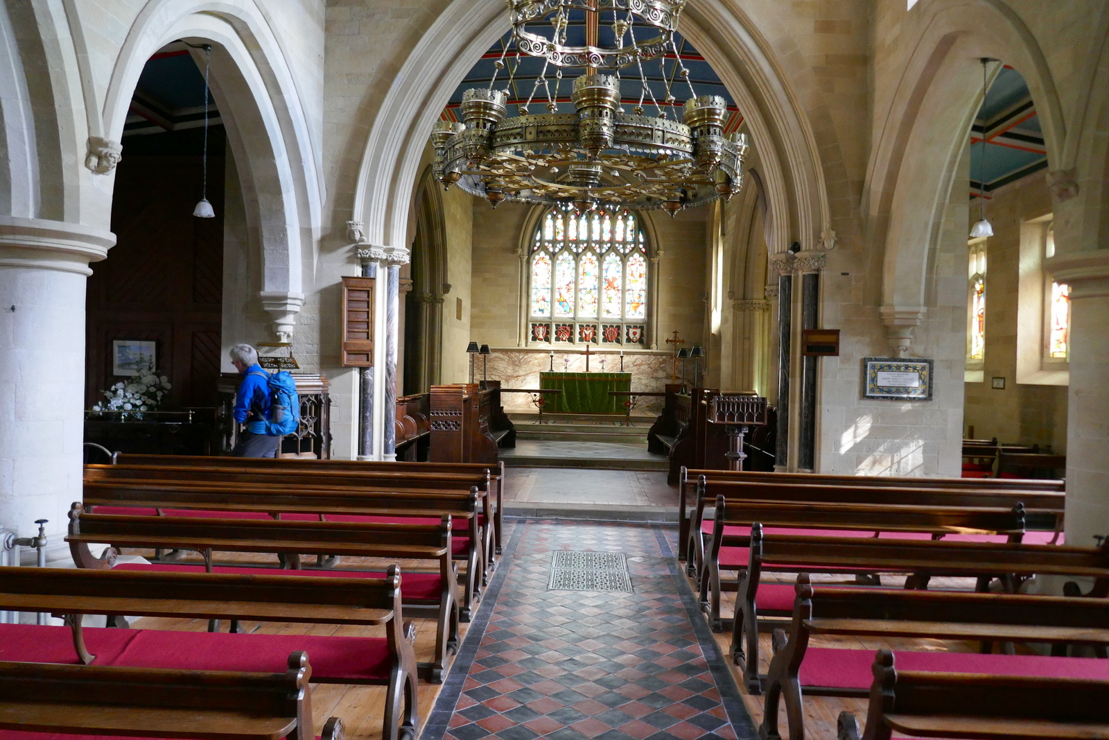
TSB says Hovingham Hall 
was given to Roger de Mowbray by William the Conqueror and came to the Worsley family in 1563, with the present Hall dating from 1745.  Next to the Hall is the Church of All Saints and seeing the door open we decided to look inside before starting our walk.

All Saints, notes inside say the tower has been untouched since it was built between 1042 and 1066

Church organ

Altar window


Looking back down the church from the altar

Some modern windows


One of the most striking features of the interior of the church is a 10th century Viking Cross, mounted high in a frame and acting as the church's altar cross.  Apparently it was once brightly painted.

The Viking Cross

Design on Viking Cross


Time was pressing as we had over 10 miles ahead of us so we set off briskly, walking past the scaffolding at the entrance to Hovingham Hall and following the road around to the rear of the hall, where we entered fields at a footpath sign.

We now had a fine view of the rear of the Hall and passed by an attractive bridge and waterfall feature which must have originally been built to be viewed from the Hall.

Hovingham School

Sign in Hovingham

Hovingham

We hesitate before joining our path but the sign is well out of date


Looking back at the rear of Hovingham Hall


A water feature

View back from the top of the folly


Shortly after passing the bridge we rejoined the road for a short time before turning left into Mill Wood, the path now following the course of a stream before rejoining the road near to Hovingham Lodge. 


Turn into Mill Wood here

Walking through Mill Wood

Leaving the wood

Pass by Thwaites Cottage

...to reach Hovingham Lodge

We now crossed fields before rejoining the road and turning in at a sign for 'Aireyholme Farm, Home of the Flitwick Flock'.  Sadly the sign has weathered and has become almost illegible.

This farm track also serves Moor House Farm before it reaches Aireyholme and as we walked cheerily along we were suddenly startled by a large white shape in the hedge.  At first glance we thought it was a sheep but as it lumbered to its feet we saw it was a  large boar which must have escaped from the farm.  It pushed its way through the hedge and out of our sight.  We walked on and saw a lady farmer at Moor House Farm.  We told her what we had seen and she thanked us and told us she had been looking for it and went off to recapture her boar.

A long walk through fields after the lodge

A brief spell on tarmac ...

.. before turning in to the farm track

... for a mile's walk to Aireyholme Farm

"Wazzat?"

... and the pig got up and slowly walked away.

We eventually passed by Aireyholme Farm, no sign of the Flitwick Flock today, and reached a fish pond and the pig fields at Howthorpe Farm.


The fish pond


Free Range Pigs


True love!


It was nice to see the pigs outdoors and living proper piggy lives.  We stood and watched them for a while before moving on to Fryton Moor where we selected a sheltered spot to sit and enjoy our coffee and scones.


Looking back at Pig Town from Fryton Moor

Time for coffee


Setting off once again we crossed several more fields before reaching the entrance to Slingsby Bank Wood. A steep climb took us to the ridge and a long gentle descent to Slingsby.   We walked through the pretty village to the Methodist church and a brightly coloured Maypole, where TSB reports that Plough Monday sword dancers once cavorted and the Slingsby Temperance Society held a great demonstration in 1851.


We reach Slingsby Bank Wood...

... and climb to the ridge

Entering Slingsby, this was a shop last time we came here

Slingsby Maypole and school


We continued through the village to reach the ruins of Slingsby Castle, which is in a dangerous state and only visible from the neighbouring road.  It was built by Sir Ralph Hastings in 1343 and enlarged by his grandson Lord William Hastings, who was beheaded for treason in 1483.


Weather vane in Slingsby


The remains of Slingsby Castle

Near the castle is The Church of All Saints, which was open so we popped inside.  This building is mainly 15th century and the most interesting feature is a Victorian bier, which is in pristine condition.


All Saints was built in 1860s in the image of its predecessor, so is 15th Century in appearance


Looking towards the altar


The Slingsby Bier


Clive examines the bier

The mask should cover the nose!

The three R's


There are interesting stone heads to inspect and a beautifully painted ceiling and it's good to find churches open to the public again, but it was time to return to our path.  We walked away from the church and castle to turn right at a sign and cross a field path at Castle Farm leading to the hamlet of Fryton.  There is little to see in Fryton and we turned left into Fryton Lane for a long and slow climb up to the woodlands of Fryton Moor.


Across fields to the hamlet of Fryton

HGV weather vane at Fryton

Fryton Lane

The plaque celebrates the finding of a 4000 year old skeleton in a nearby burial henge


On reaching the trees we turned right where the path leads through trees for a mile and a half.  Towards the end of this stretch the path is easily missed because of recent forestry work and concentration is needed. Eventually we turned north to join the straight path that would take us back to Hovingham.


A plethora of directions

Walking along South Wood

Looking back at the trees of South Wood

Storm clouds gather... but soon disperse

The houses of Hovingham appear in the distance


Widows alms houses


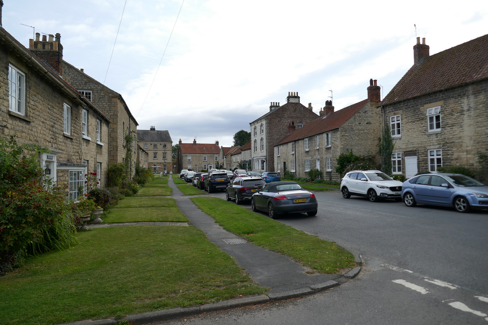
Entering Hovingham High Street


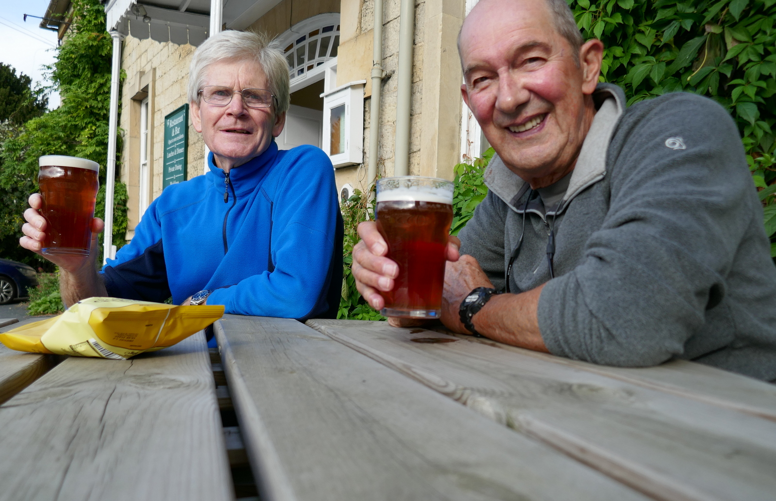
Hovingham appeared below us and we walked straight into the village and almost immediately reached the welcoming doors of the Worsley Arms Hotel.  Here we sat outside with a pint to discuss today's walk, which is a long one but much recommended.


Weather vane in Hovingham

Walking down the High Street

Clive veers into the Worsley Arms

"Happy hiking!"


Friday 17 September 2021

Caydale and Noddle End from Murton


7.5 miles                           Sunny and warm


We drove to Murton Grange taking the Laskill turn-off from the B1257 Stokesley to Helmsley road and parked on the verge near to the white buildings of the Grange.


Today's walk from The Walker's Guide to the Hambleton Hills

Murton Grange


Tom Scott Burns explains that a 'grange' was a farmhouse attached to a religious order and Murton Grange once belonged to the monks of nearby Byland Abbey. 

We walked past the Grange and continued straight ahead until arriving at a fork, the main lane going on to Caydale Mill but we took the right fork down into the hidden valley of Caydale.  Tom Scott Burns tells us that at this spot the last wild cat in England was shot in 1840, by a Charles Harrison. 

Walking towards Caydale

Leave the lane by the right fork

.. and walk on towards the valley of Caydale

The sheltered valley of Caydale

We reached the bottom of the valley and crossed several streams of crystal clear water, known as 'rills'.  These are 
shown on the map above as Old Byland's Water Race and Limperdale Gill.  In the 1740s a Joseph Ford of Kirbymoorside perfected a system of tapping into springs and channeling water in open 'rills' some 12 inches wide.  Water was diverted by this method through Caydale from King Spring to the village of Old Byland and the straight rills remain.  

Caydale bottom

One of the 'rills'

We are distracted in Caydale by a buzzard being mobbed by crows

Another buzzard appears and the crows move off..


We crossed the valley floor and started up the other side.  Until a couple of years ago this climb was through trees but all vegetation has been removed and the area converted to rough grazing meadow.

A consequence of this clearing has been the removal of the old 'Captain's Seat' which is shown on the map above, and which we used to pass by, although in a dilapidated state. We would like to know who the Captain was and why he would sit at such a remote spot.

Leaving the climb and Caydale we crossed several fields to reach the tarmac of High Leir Lane where we turned right and walked through shimmering heat to pass Weathercote Farm with its novel 'cat and rat' weather vane.

Looking back across Caydale at Murton Grange on the horizon

High Leir Lane

A collared dove acts as referee on the weather vane...

... at Weathercote Farm

After a mile we reached the junction with Cleveland Road which we crossed to follow field paths again, until reaching the high ridge of Boltby Scar.  We were ready for refreshment by this time and we followed the ridge to the old quarry workings where we sat with a magnificent view over Boltby and enjoyed our coffee and scones in a slight and very welcome breeze.

Pheasants lead us towards Boltby Scar.  Safe until October 1st!

We reach the ridge and the Cleveland Way and bear left

Boltby Village below


High Barn appears in the distance

Remains of old fort and quarry.... and coffee stop

We set off and walked towards the Old Barn, walking straight past it following the Cleveland Way. 
We crossed Sneck Yate Bank Road, opening the gate for a couple of cyclists, and continued along a forest path to High Paradise Farm, which now has a tea room in the summer months.  Although it was nearly 30 minutes since we had our coffee break we showed amazing will power and walked on past walkers enjoying their coffee at the farm cafe, soon reaching the gate with the old drovers' road, Hambleton Road. 

Passing Old Barn


Low Paradise left and High Paradise Farm to the right


Entering Boltby Forest


High Paradise Farm and tearoom


Walking towards Hambleton Road

Crossing Hambleton Road towards Daletown Common

Daletown Common

Two of the sheep had red horns, we wondered what that signifies


At Hambleton Road we crossed straight over and walked onto Daletown Common where we continued for about two miles towards the old ruined barn at Noddle End.   As we walked we passed several freshly dead partridges and saw a large group of beaters being collected by transport on the road ahead.  Partridge season is 1st September to 1st February so they are 'fair game' at the moment.

Fresh partridge

Beaters being collected

The dogs must have missed these..


When we reached the barn we paused to enjoy a pleasant view into Gowerdale, before following the path down to reach the ruined farm of Gowerdale House.   Looking across towards Murton Bank we could see my car and a line of shooters' vehicles approaching it from Gowerdale, probably on their way for refreshments after the shoot.


Approaching Noddle End

The disused barn at Noddle End

My zoom lens shows the shooters approaching my white car


The path now leads steeply downhill to a single deserted farmstead, Gowerdale House. 

In his 'Round and About the North Yorkshire Moors, Vol. 2' Tom Scott Burns tells us that Gowerdale House is all that remains of a medieval village, called Dal in the Domesday Book, and Daile a century later. By 1433 there were 23 tenants recorded as living in Daletown but by 1569 in Humberston's Survey the entry was 'vocatum Dale Town'. Was the village wiped out by the Black Death?


Starting to descend into Gowerdale

Gowerdale House


Dozens of partridges take to the air 


We reach the bottom of the valley and Gowerdale House

A partridge watches us pass by Gowerdale House

The message, now hidden, says "Look around and Get Out!"


We passed the front of the house which has the bleak message, "Look around and get out!" painted on the front door, and then followed a rising path to reach Dale Town Farm.


Dale Town Farm

We turned right into a cow field just after passing the farm buildings and followed the faint path steeply uphill to the top of Peak Scar Top where we turned left to reach Murton Bank Road and the car.

Reaching the car we looked down on the village of Hawnby and its pub, The Owl.  We were soon seated in the pub garden enjoying a pint and discussing today's walk.

Climbing to Peak Scar Top

Hawnby below

Hawnby Hill and Easterside Hill from Murton Bank

A pleasant end to our walk at The Owl at Hawnby