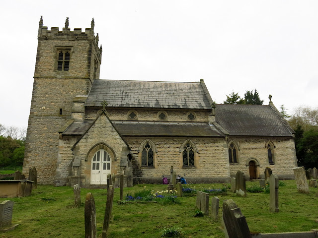
Stonegrave and Caulkleys Bank from Nunnington
7 miles Fine and bright
We approached Nunnington on the B1257 from Helmsley and parked in a lay-by opposite Nunnington Hall, next to the river.
Clive is unable to walk at present so I was accompanied/supervised by my wife, Carole.
 |
| Today's walk from The Walker's Guide to the Hambleton Hills |
 |
| Nunnington Hall |
 |
| The Old School House |
 |
| Neat streets with houses painted cream and green |
 |
| Southdown sheep at Nunnington |
 |
| Leaving the village to follow the River Rye |
At the end of the village we followed a footpath sign directing us through a gate and onto a field path running alongside the River Rye. After about a mile we crossed a small bridge over a tributary and immediately turned left to follow a faint path through fields.
 |
| River Rye |
 |
| Field path alongside the river |
 |
| We won't cross this one... |
 |
| Turn left immediately after this bridge |
 |
| Approaching Low Moor Plantation |
We turned left onto the tarmac of High Moor Lane and after a hundred yards or so turned left again at a signpost to return to fields. After half a mile or so we dropped down to reach the busy Malton road and the village of Stonegrave.
 |
| Carole notices that the word Stonegrave is missing from the sign |
 |
| My hay fever was irritated as we walked through heavy pollinated fields of Rape |
 |
| This chap came begging to us. If only pigeon fancier Clive was here he would have known what to do! |
 |
| Turning off High Moor Road into more fields |
 |
| Reaching the Malton road, Stonegrave Minster ahead |
TSB says that Stonegrave is derived from steinn-gryfia meaning a 'stone cleft', and there were important quarries of building stone here in the Middle Ages.
We turned off the busy road and walked past an Elizabethan manor house to reach the tiny and ancient Stonegrave Minster which was mentioned in an eighth century letter from Pope Paul to Eadbert, king of Northumbria.
 |
| House in Stonegrave |
 |
| Elizabethan manor house |
 |
| We arrive at the minster |
The minster was unlocked and we entered to find a magnificent Celtic cross just inside the church. We spent ten minutes wandering around inside the old building before emerging to sit on a bench and enjoy coffee and scones in this peaceful setting.
 |
| Inside the minster |
 |
| Altar window |
 |
| The Thornton Tomb |
 |
| Celtic cross |
 |
| Detail on cross |
Finishing our coffee we wandered around the grave yard looking at some of the old stones and reading their inscriptions before returning to cross the Malton road and join a grassy path which veered left from the road to climb Caulkleys Bank.
 |
| Another dyslexic stone mason? Note the 4 in 1846 |
 |
 |
| Stonegrave Minster |
 |
| Norman heads at Stonegrave Minster |
The name Caulkleys is a corruption of 'Chalk Lands' and in The Walker's Guide to the Hambleton Hills one reads that the terrain here consists mainly of rich deposits of reef limestones and detritus known as Coral Rag, all pointing to the marine origins of this hillside.
Reaching the top of Caulkleys Bank we walked along the grassy ridge and after passing Caulkleys Wood we had fine views in all directions. TSB says that no less than 22 towns, villages and hamlets and sixteen churches can be seen from the highest point, marked by a trig point.
 |
| Caulkleys Bank |
 |
| Thatched roofs from Caulkleys Bank |
 |
| We need to follow 'The Avenue' |
 |
| Approaching the trig point |
 |
| 22 towns and villages....?
All along the ridge we saw cowslips coming into bloom. It was nice to see such large numbers of this increasingly rare flower.
|
 |
| Cowslips |
 |
| Walking alongside Scroggy Wood |
 |
| Cowslips |
 |
| Arriving at West Hall.... |
 |
| .... and West Ness Hall cake stall |
 |
| The choice of cakes had been much reduced by the time we left! |
Just past a Wesleyan chapel built in 1836, the path leaves the road and rejoins the River Rye. We walked alongside the peaceful river for about 1.5 miles and reached Mill Farm.
 |
| Sheep at West Ness |
 |
| Wesleyan Chapel |
 |
| The phone box is in worse repair than the chapel |
 |
| Working order? |
 |
| Rejoining the River Rye |
TSB says there has been a mill here since Domesday and the present mill dates from 1875. Until 1950 the mill race powered a generator providing electricity for Nunnington Hall.
 |
| Mill Farm |
 |
| I decide not to stroke the mill cat |
 |
| Mill Farm |
 |
| Mill Race |
Continuing alongside the river we reached Nunington Hall, where the screeching of peacocks could be heard. This was owned by Sir Thomas Parr in the sixteenth century so it's possible that Catherine Parr, Henry VIII's last wife, played in the village as a child.
 |
| Nunnington Hall from our path |
 |
| Attractive bronzes in the Hall grounds |
 |
| Old Alms Houses, now the village hall |
 |
| Weather vane at Nunnington Hall |
We had plenty of time left so decided to visit the church of All Saints and St James, which dates to the 12th century. The church was unlocked and visitors are welcome.
 |
| All Saints and St James |
 |
| All Saints and St James |
 |
| Victorian organ |
 |
| Altar window |
 |
 |
| Memorial stones inside the church |
 |
Returning to the outside world we spent some time looking at the inscriptions and epitaphs in the graveyard before wandering over the road to the Royal Oak public house where we contemplated our mortality (and discussed today's walk) over a pint of York Brewery's Thumper Ale.
 |
| 'The lovely bud,so young,so fair, Called hence by early doom, Just came to show how sweet a flower, In paradise should bloom' |
 |
| 'Our flesh will slumber in the ground, Till the last trumpets joyful sound, Then burst the chains with sweet surprise, And in our SAVIOUR'S image rise' |
 |
| I begin to suspect Carole doesn't share my enthusiasm for Victorian epitaphs |
 |


