Along the Old Drovers' Road from Osmotherley
6 miles Cool and dry
We approached Osmotherley from the A19 and discovered that parking in the village is more difficult than it's ever been, necessitating a drive around the village until we came upon a recently vacated spot, and grabbed it.
 |
| Today's walk from The Walker's Guide to the Cleveland Hills |
 |
| We parked below this fine weather vane |
 |
| And walked past these houses dated 1821 |
In the Domesday Book Osmotherley is known as Asmundrelac, which means 'Asmund's clearing'. We would walk past a cottage bearing this name on our return.
After booting up we went past the Market Cross into Quarry Lane and walked uphill admiring the fine buildings and spotting a couple of weather vanes and a restored pinfold before turning left into Rueberry Lane.
 |
| Turn left into Rueberry Lane at the sign |
Tom Scott Burns explains in his notes for the walk that the village was ravaged by William the Conqueror in 1069 and was still described as waste land in its entry in the Domesday Book in 1085.
He also relates that the village was raided by the Scots on several occasions and a raid in 1315 was so severe that the village was excused all taxation because of the distress it had suffered. A few years later, in 1348, the Black Death carried off nearly half the population of Osmotherley.
We quickly gained height until we looked back down on Osmotherley. A little further, when the lane becomes a track, is the Lady Chapel founded by Queen Catherine of Aragon in 1515. It is still a religious retreat and we followed the twelve stations of the cross as we approached it. We were pleased to see the door unlocked and popped in for a look around.
 |
| Looking back at Osmotherley from Rueberry Lane |
 |
| Follow the sign at your own risk! |
 |
| Viewpoint |
 |
| First Station of the Cross |
 |
| Lady Chapel |
 |
| Looking towards the altar in Lady Chapel |
 |
| Clive stands beneath the west window |
 |
| Explanation for the shields on West Window |
Leaving the Lady Chapel we dropped down to a track where we turned right, now following the Cleveland Way. This track has a fine view over the Vale of York and we walked along picking out landmarks such as The Tontine on the A19 below.
 |
| Leaving the Lady Chapel |
 |
| We join the Cleveland Way with a fine view below |
 |
| This used to be a very confusing sign for C2C walkers... |
 |
| ... but the explanatory notice now keeps them right |
We walked uphill through the birch trees of South Wood to reach transmitter masts. When we walked past this transmitter station in 2014 we noticed a nice sign on the old gate which is mentioned by Wainwright in his 1973 Coast To Coast Guide. Unfortunately the gates have been replaced in the last couple of years and the sign thrown away with the old post.
 |
| Walking by South Wood |
 |
| The Transmitter Station |
 |
| The old notice |
We now walked through Scarth Nick to reach Sheepwash. TSB explains that during the Ice Age of approximately 20,000 years ago, a glacier from the north enveloped an area 20 - 30 miles wide and 1,000 or more feet thick. It failed to cover the moors but crept into Scugdale depositing materials from Scotland, Cumbria and Durham. Sand, gravel and stones left by meltwater formed the conspicuous mound of Round Hill, the present car park at Sheepwash.
Reaching the water splash at Sheepwash we crossed the bridge and sat on Crabdale beck's stony bank to enjoy our coffee and scones.
 |
| Scarth Nick |
 |
| Car park at Sheepwash |
 |
| Crabdale Beck |
Crabdale Beck is a nice sheltered spot and after enjoying our coffee and scones we headed uphill towards Pamperdale Moor.
We now walked along High Lane alongside the forestry plantation above Cod Beck Reservoir. This was once a Drovers' Road and TSB suggests that it was probably used by prehistoric man, the Romans and, before the present day road was made, as a corridor through the Cleveland Hills.
Over to our left we saw an unusual brick building which we have previously investigated and found to be a WWII Starfish, one of five such sites built during the last war to protect industry at Teesside by the following means:
A series of iron tanks, raised on gantries, would be set out. These tanks held inflammable liquid that could be ignited and quenched on demand. The fires were lit as soon as German bombers began an attack. When they were quenched, the resulting steam looked like the smoke of a burning city, and enemy pilots would drop their bombs harmlessly on the moors instead. Such decoys were officially known as ‘SF’ or ‘Special Fire’ locations, but were generally called ‘Starfish’ sites.
Last time we visited we suspected that the site is still in use, possibly for astronomical reasons, so we walked across to see if we could find out anything further.
 |
| High Lane |
 |
| We enter the moor to visit the Starfish Site |
 |
| A new steel door prevents us looking in |
 |
| Clive remembers there was something attached to the wall |
 |
| Repairs to concrete and bollards added |
We were surprised to see that concrete bollards had been positioned at the base of each sloping wall and we could think of no reason for their presence. A new steel door has been fitted and the grille that we had looked through last visit was no more.
 |
| Inside the Starfish last visit |
 |
The papers appear to be headed 'Near Earth Asteroids'
|
Disappointed that the present use of the Starfish remains a mystery we returned to High Lane and continued on our route. As we reached the tarmac road from Osmotherley we passed the ruins of Solomon's Temple, which was built by the eccentric Solomon Metcalf in 1812 and had images of the sun, moon and stars on its walls. Now only fallen stones mark the spot.
Shortly afterwards we reached Chequers Farm. This interesting building was an old inn and held a licence for 300 years until 1945. When it was a hostelry it was famous for keeping an old peat fire alight for 150 years! The sign of the Inn was a chequers board and TSB says this was derived from the chequers that were handed to the drovers to be exchanged for refreshment at the inn. The sign was the cryptic message "Be not in haste, Step in and taste, Ale tomorrow for nothing." Of course as we all know tomorrow never comes. The old sign has been mounted behind glass on the farm wall.
The building has been repainted since our last visit and was featured in the Christmas edition of Paul Whitehouse and Bob Mortimer's fishing show last year, when the duo used it as their base for the TV programme.
 |
| Only stones mark the location of Solomon's Temple |
 |
| Chequers |
 |
| Its original sign |
 |
| The frame of the old inn sign still remains |
TSB notes that drovers used to bring vast herds of cattle from the Highlands of Scotland across the Hambleton Hills on their way to the markets of East Anglia, the Midlands and London. Their average pace was just 2 miles per hour.
We turned right at Chequers Farm where the path heads gently downhill towards the two small reservoirs at Oakdale. A little way down this track is a family memorial placed against the wall, which commemorates one of our region's war heroes, Ronald Tucker.
 |
| Turn right off High Lane |
 |
| Memorial to Ronald Tucker |
For more about Ron Tucker see here Reaching Oakdale we crossed the beck by an old packhorse bridge and on leaving the reservoirs we joined the farm road across Slap Stone Beck (apparently this name refers to slippery stones at the ford) where we admired an attractive conifer garden before entering Green Lane to pass by White House Farm.
 |
| Looking back at Chequers |
 |
| The trees of Big Wood in the distance |
 |
| Over the bridge... |
 |
| ... is Lower Oakdale reservoir |
 |
| A tall crop of bamboo, perhaps providing bird cover |
 |
| Attractive conifer garden |
 |
| Clive recites the latin names of the conifers |
 |
| Green Lane |
Our path descended past White House Farm and then continued across a small bridge over a stream and steeply uphill to where the path crosses a field and into Osmotherley.
 |
| Through a pinch gate |
 |
| Bridge over Cote Ghyll |
 |
| The old chapel has a (old!) new name |
Entering the village along narrow alleyways we noticed an old chapel in the terraced row of cottages, obviously still in use. Tom Scott Burns tells us that John Wesley preached in Osmotherley in 1745 and the chapel was built nine years later. Wesley returned to preach again at Osmotherley in June 1761 and probably used this chapel.
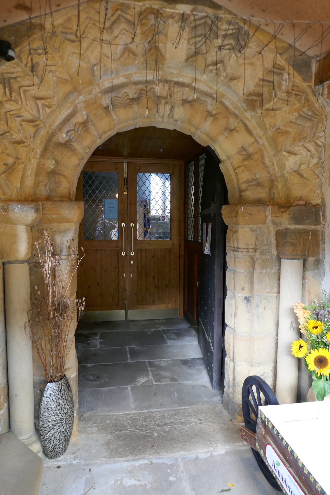
We crossed the road and went behind the Queen Catherine Hotel to look at the 12th Century St Peter's Church, which is almost hidden from view on the High Street.
It was unlocked and we went inside to look around. The tower is 15th century and the walls were built on Norman remains. There are fragments of Saxon crosses and part of a hogback in the porch.
 |
| Down the alley past the blue bins.. |
 |
| .. leads to St Peter's Church |
 |
| Parts of Saxon Cross |
 |
| A sign of the times... |
 |
| Another sign of the times |
 |
| Looking towards the altar |
 |
| Victorian organ |
 |
| Social distancing in the pews |
We spent a little time exploring the village and then found that our feet had taken us to the Golden Lion so we lingered there a while to discuss today's walk over a pint.
 |
| The Hikers' Reward |


No comments:
Post a Comment