Rosedale Railway and Botton Head from Ingleby Greenhow
8.5 miles Fine but breezy
My boots still dusty from walking The Corfu Trail, we parked in Ingleby Greenhow in the overflow car park for the Dudley Arms and walked back to the main road and followed it in the direction of Kildale. The route parts from the road alongside a modern house where a signpost directs one into a narrow path between houses onto meadows. This path has almost disappeared between vegetation and close fences.
 |
| Today's walk from The Walker's Guide to the Cleveland Hills |
 |
| Ingleby Greenhow |
 |
| Beautiful garden at the Old Vicarage |
 |
| Turn right at the signpost |
 |
| There's a hundred yards of this narrow passage |
Tom Scott Burns notes in
his Walker's Guide to the Cleveland Hills that the name Ingleby has
been written in various ways over the years, including Angleby, Engelbi,
Yngleby and Yngylby.
We emerged from the narrow path to fields and over to the right we could see Ingleby Manor which dates from 1540 and is now holiday accommodation.
We
climbed steadily and passed by some old graffiti of a man wearing a
stovepipe hat with a bird in front of his face. TSB suggests that this
is a satirical caricature carved by a railway navvy in a moment of
inactivity.
Nearing the top we sat in a sheltered spot to enjoy our coffee and scones, watching a couple of curlews who we suspect were trying to distract us from their brood.
 |
| Curlews |
 |
| Curlew on the ground |
 |
| .... and in the air |
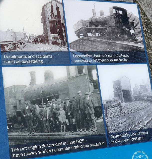
After coffee a short stroll took us to another information board at the site of the old drum house, which was dismantled in 1941. Here there is a cast iron model showing the old workings at the Incline top.
 |
| The curlews definitely want us gone! |
 |
| But first we examine the cast iron model |
 |
| ... showing how the old railway looked |
We set off once again to follow the railway bed; the railway officially
closed on 13th June 1929 and now makes a nice 11 mile path to Farndale,
Westerdale and Rosedale. After several hundred yards we turned off the railway at a broad track and joined a trail leading to Cockayne Head and Botton Head. We were now walking along the Cleveland Way.
 |
| 11 mile path across the moor |
 |
| Sadly we presume this was vandalism as the seat was securely anchored |
 |
| Leave the old railway track at this right turn |
 |
| .. to join the Cleveland Way |
As
we walked this trail, which also serves the Coast to Coast walk, we
came to two old boundary posts. The first, known as The Face Stone, is
mentioned in a 1642 document for the Helmsley Estate and the second,
showing a carved hand, near to Round Hill, dates from 1711. Near the
Hand Stone is the trig point at Botton Head which is located on a Bronze
Age burial mound at 1490 feet, the highest point on the North York
Moors. We walked over to examine it but the view from here is not very good, even if it is the highest spot.
 |
| Now following the Cleveland Way |
 |
| Unusual to see a mallard duck on the moors |
 |
| The Face Stone |
 |
| The Hand Stone, almost indecipherable because of lichen |
 |
| Trig Point |
We
walked back to the wide path to continue walking across Urra Moor,
which according to TSB derives from the Old English 'horh' meaning
'filth'. Eventually
we came to a new signpost where we left the Cleveland Way to bear right
on an indistinct path which drops off the moor down Jackson's Bank and
into Greenhow Plantation.
Over
to the right we could see the incline railway while ahead of us
Roseberry Topping appeared in the distance. A mile or so on and several
farms further, the tarmac lane took us to Low Farm.
Just
before the farm buildings of Low Farm we turned into fields that we
crossed one after another, at first following a newly fenced path, but
later by aiming for the yellow right of way signs on each field
boundary.
 |
| Walking through fields |
 |
| ... past sheep |
 |
| ... and horses |
Eventually we reached the bridge over Ingleby Beck and we crossed into the churchyard of St Andrew's beyond it. The church was unlocked and we went in for a look around.
Leaving the church we found The
Dudley Arms at Ingleby Greenhow had closed for the afternoon but a
short drive took us to the fleshpots of Great Ayton, where we discussed
today's walk. We agreed it was one of TSB's best with lots to see and
varied walking on hills, moors, woods and meadows.
 |
| "To the Ingleby Incline and all who climb it!" |


Good to chat to you both, it's not often we get 'celebrities' visiting Greenhow Botton. John
ReplyDeleteHa! We've been called many things before but never celebrities! Cheers Huw and Clive
ReplyDelete