A Tour of Raisdale from Chop Gate
7.8 miles Sunny with cool wind
We parked at Chop Gate Community Centre on the B1257 where there is space for many cars. Unfortunately there is now a parking charge here but today the ticket machine was out of order. If it isn't out of order for you then I suggest parking in the large pub car park at the Buck Inn, after first obtaining permission from the licensee and promising to buy a pint at the end of your walk.
Clive was busy so my wife agreed to accompany me on today's Tom Scott Burns walk which we haven't done for four years. After booting up we climbed over a stile at the rear of the car park and followed a faint trail next to Raisdale Beck, across wet meadowland towards Cock Flat Farm.
.JPG) |
| Today's walk from The Walker's Guide to the Cleveland Hills |
 |
| Community Centre with passive/aggressive sign |
 |
| Whoopee! |
 |
| Stile at the rear of the Community Centre |
 |
| Alongside Raisdale Beck |
Our path wandered through several fields climbing above Raisdale (Reith's Valley, an old Norse personal name) and then a steep climb took us to a higher path leading to High West Cote Farm where we should have had a splendid view of our route ahead, but early morning mist had yet to burn off. |
| Cross straight over Raisdale Road |
 |
| Raisdale Beck |
 |
| A steep climb to the stile |
 |
| ... then sharp left and follow the fence line |
 |
| Still some mist about |
 |
| Keep crossing sheep fields |
 |
| Collapsed stile |
 |
| West Cote Farm |
After High West Cote we dropped down to reach Raisdale Road once more, just before well ordered Stone Intake Farm, and immediately after passing the farm buildings we climbed a stile on our left and descended through a field to Raisdale Road.
 |
| West Cote Farm lane |
 |
| Definitely not passive sign at Stone Intake Farm |
 |
| Still a few snowdrops |
 |
| Neat landrover planter |
 |
| Just past the buildings cross the stile |
TSB notes that this section of Raisdale Road is referred to in the 1160 Rievaulx Charters as the 'Red Road', perhaps derived from the red shale in this area. We followed it for a couple of hundred yards until we turned into the entrance of Raisdale Mill on our left.
We walked down to the old mill buildings, originally built by John Garbutt in 1849. These ceased operating in the 1920s.
 |
| The Red Road |
 |
| Approaching Raisdale Mill |
 |
| Raisdale Mill |
 |
| Green lane no more |
We walked past the restored buildings, now attractive homes, before turning sharp right into what Tom Scott Burns describes as 'a most beautiful green lane.' Sadly years of motorcycle trail bikes mean it is a green lane no more. Last time we came this way there was a No Motor Vehicles sign but this has now been removed.
We now had a steady climb up this 'hollow lane' shown on the OS map as Mill Lane, eventually reaching the top and Barker's Ridge, with the rocky outcrop of Barker's Crag to our right. We followed the ridge to pass by High House and continued climbing until we came to a gate on our left. Here we settled down on a grassy slope to enjoy our coffee and scones with a misty view back of our walk so far.
 |
| Our misty view back into Raisdale |
 |
| Coffee and scones in the sun |
 |
| Barker's Craggs |
After coffee we resumed walking along Barker's Ridge towards the head of Scugdale. After half a mile or so we came to a surprise view of Scugdale and we paused to pick out Holiday House and Scugdale Hall before continuing our march across the moor.
 |
| Moor yomping |
 |
| Old boundary stone marked CD |
 |
| Scugdale to our right |
A steady 2.5 mile walk across the moor followed and just before we reached a junction with a path joining from the right, we saw old concrete foundations. A Google search shows the foundations were probably from a decoy site built in WW2.
 |
| War time decoy site? |
 |
| The foundations are only visible in winter months |
The path eventually leads to Head House which we have seen change over the years, from a ruin to a store where game bird feed and equipment is kept. The building is never locked so is a useful shelter in bad weather. We walked down to look at it.
 |
| Turn left at the junction |
 |
| Approaching Head House |
 |
| Graffitti in Head House |
 |
| Looking out of Head House |
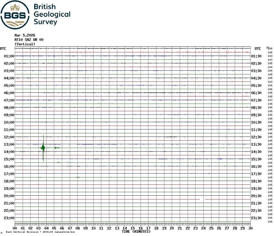
In TSB's map above he shows three stone walled fields adjacent to Head House and in the last corner of the third field we saw the solar powered screen of the earthquake detector we first spotted in early 2017. We decided to walk over to look at it and crossed fields directly to it. In the field before the detector we came to a scene of carnage with dead birds and rabbits scattered around. The rabbits looked fresh and we wondered if it was feeding area for buzzards, and I noticed an outdoor camera fitted to a gatepost overlooking the site. We would find out more shortly but meanwhile walked on to the earthquake detector.
 |
| Carnage! |
 |
| Some things look freshly killed |
 |
| Camera! |
 |
| Solar panel and earthquake detector |
 |
| Detector |
We looked at the time (1.30pm) and jumped up and down next to the box. To see the result of our behaviour click this link, which shows this particular detector and look at what happened at 1.30pm! For more about these detectors see:
We climbed over a high stile to leave the detector's field and saw that heather was being burned nearby and a worker was sat on a quad watching it. We mentioned the dead rabbits and game and the camera we had seen and he said it was theirs, and they were attracting foxes. "To film them?" I asked, "No, to shoot them" he replied. Oh well, that solved that mystery.
After this interesting diversion we resumed our tramp across the moors, dropping down to Arns Gill where we crossed the stream with a jump. The path took us by an ancient rowan tree, fallen but still alive and described in the '80s as 'weathered' by TSB.
 |
| We spot targets for shooting practice |
 |
| High stile out of the detector's field |
 |
| We chat to a passing keeper |
 |
| The old rowan tree |
 |
| TSB probably sat here |
 |
| Heather burning |
 |
| A narrow path across the moor |
We followed a narrow path across the moor which must have been an ancient trod, as occasional stone slabs would appear. We climbed steadily up Trennet Bank to its cairn where we found the standing stone had been somehow knocked down.
 |
| Where's the standing stone? |
 |
| How it used to look |
A number of hollow-ways descend Trennet Bank to Chop Gate, which TSB says were worn over many centuries by sledging turf from the moor tops for fuel, and we set off on our descent.
 |
Thomas Leckenby sledging turf on Urra Moor, from 'Round and About the North Yorkshire Moors' by Tom Scott Burns
|
Hollow lanes are ancient pathways which have been hollowed out over time, very often where peat or turf was dragged down from the moor on sledges. Above is a photograph of Thomas Leckenby of Mount House Farm Bilsdale, leading his sledge of turves off Urra Moor in the early 1930s. The strips of cut turf were dried in heaps called 'rooks' and were used as fuel and for building walls.
 |
| Carole starts the descent, Chop Gate below |
 |
| In a hollow-way |
 |
| Back at the Community Centre |
This is a nice moorland route but the paths are little walked and sometimes indistinct. I would be happy to send my GPS track on request and would recommend using this to anyone wishing to attempt the walk for the first time.
A lovely day for early March and we had our first outside debrief of the year.
 |
| To Raisdale! |
.JPG)


