Rosedale Railway and Botton Head from Ingleby Greenhow
8.5 miles Fine but cold wind
A busy week of walking for me. First in the Lakes (maps and some photos here) and now with Clive on this fine Tom Scott Burns walk back in North Yorkshire.
We parked in Ingleby Greenhow in the overflow car park for the Dudley Arms and walked back to the main road and followed it in the direction of Kildale.
 |
| Today's walk from The Walker's Guide to the Cleveland Hills |
Tom Scott Burns notes in his Walker's Guide to the Cleveland Hills that the name Ingleby has been written in various ways over the years, including Angleby, Engelbi, Yngleby and Yngylby.
The route parts from the road alongside a newly built house where we followed a narrow path between houses onto meadows. This path has almost disappeared between vegetation and close fences. Over to the right we could see Ingleby Manor which dates from 1540 and is now holiday accommodation.
 |
| The Old Vicarage |
 |
| Turn right at the footpath sign |
 |
| Narrow right of way between houses |
 |
| Gets tricky in places |
 |
| Emerge into meadows |
 |
| Lapwings appear to be nesting in the meadow |
 |
| Ingleby Manor |
We crossed several sheep fields to reach Bank Foot Farm, situated under Turkey Nab. At the farm we turned right to follow the old railway track. Here, if one turns off the track soon after Bank Foot to head uphill through the plantation, you can find Lady Mary Ross's Seat, described by TSB as being at grid reference 594055.
 |
| Walking through sheep fields |
 |
| Faint track and waymark signs, Bank Foot Farm in distance |
 |
| Bank Foot Farm |
 |
| Noisy residents at Bank Foot |
 |
| The old railway track at Bank Foot |
 |
| Lady Mary Ross's seat |

TSB explains that Lady Mary Ross was the eldest daughter of the Earl of Kildare and her daughter had married Sir William Foulis of Ingleby Manor. The seat might have been constructed on one of Lady Mary's favourite walks, taken when visiting her daughter and son-in-law, in the days before the hillside was covered in conifers.
The seat is situated on the forest track running about 100 metres behind and parallel with our route and after seeing it one can cut back through the trees to rejoin the 'official' path.
Returning to the old railway bed we followed it for a couple of miles, passing a row of railway cottages and eventually reaching the start of the incline railway bed.
 |
| Bluebells in trees alongside the old railway track |
 |
| We have company for a while |
 |
| Old railway houses |
 |
| The incline railway bed to the left |
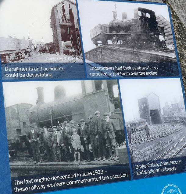
We paused to read the information board before setting off uphill.
 |
| Clive deciphers the sculpture |
Tom Scott Burns tells us that the old railway was completed in 1861 leading to the foot of the incline bank where the trains were loaded with ironstone. The incline reaches a maximum gradient of 1 in 5 and a brake drum house was situated at the top. Three empty wagons were hauled up by steel ropes as three loaded wagons descended, an operation which took 3 minutes at a speed of 20mph, regulated by the drum house.
Leaving the information sign we started our long climb up the old incline railway.
We climbed steadily and passed by some old graffiti of a man wearing a stovepipe hat with a bird in front of his face. TSB suggests that this is a satirical caricature carved by a railway navvy in a moment of inactivity.
 |
| Old graffiti |
 |
| Nearly at the top |
 |
| We found shelter here out of the wind to enjoy our coffee and scones |
After coffee a short stroll took us to another information board at the site of the old drum house, which was dismantled in 1941. Here there is a cast iron model showing the old workings at the Incline top.
 |
| Remains of the Drum House |
 |
| Clive examines the cast iron model |
Today's brisk northerly wind made us realise what a hard life these workers must have endured. We set off once again to follow the railway bed; the railway officially closed on 13th June 1929 and now makes a nice 11 mile path to Farndale, Westerdale and Rosedale. After several hundred yards we turned off the railway at a broad track and joined a trail leading to Cockayne Head and Botton Head. We were now walking along the Cleveland Way.
 |
| Turn right off the old railway |
 |
| ... and join the Coast to Coast and the Cleveland Way |
 |
| The Cleveland Way |
As we walked this trail, which also serves the Coast to Coast walk, we came to two old boundary posts, the first known as The Face Stone, is mentioned in a 1642 document for the Helmsley Estate and the second, showing a carved hand, near to Round Hill dates from 1711. Near the Hand Stone is the trig point at Botton Head which is located on a Bronze Age burial mound at 1490 feet, the highest point on the North York Moors. We walked over to examine it but there is not a very good view from here, even if it is the highest spot.
 |
| The Face Stone |
 |
| Graffiti on back of Face Stone 'GH 1812' and 'AW' .. oh no, surely not! |
 |
| Hand Stone, almost indecipherable with lichen |
 |
| Trig Point |
We walked back to the wide path and to continue walking across Urra Moor, which according to TSB derives from the Old English 'horh' meaning 'filth'. Eventually we came to a new signpost where we left the Cleveland Way to bear right on an indistinct path which drops off the moor down Jackson's Bank and into Greenhow Plantation.
 |
| New 'AW' Coast to Coast sign |
 |
| Hasty Bank in the distance |
 |
| Turn right at the sign |
 |
| We can see the incline track opposite |
After a steep descent through trees we reached the bottom of Jackson's Bank, curiously marked Clogger's Hall on the OS map, but nothing is to be seen, and then crossed Greenhow Botton to walk towards New Sheepfold Farm. We passed several signs showing that New Sheepfold Farm have diversified into selling their produce.
 |
| Starting the descent of Jackson's Bank |
 |
| Steeply downhill |
 |
| High Farm to the right |
 |
| Heavy smell of blossom |
 |
| Walking towards New Sheepfold Farm |
 |
| Lamb Creche |
 |
| Soay Sheep |
 |
| Holiday huts at New Sheepfold Farm |
Over to the right we could see the incline railway while ahead of us Roseberry Topping appeared in the distance. A mile or so on and several farms further, the tarmac lane took us to Low Farm.
 |
| Lovely working horses at Low Farm |
 |
| A heron passes overhead |
 |
| Looking back at our outward climb |
 |
| Appropriate weather vane at Low Farm |
Just before the farm buildings of Low Farm we turned into fields that we crossed one after another, at first following a newly fenced path, but later by aiming for the yellow right of way signs on each field boundary.
 |
| Pink hawthorn blossom |
 |
| Path along field margins |
 |
| The bridge at Ingleby Beck |
Eventually we reached the bridge over Ingleby Beck and we crossed into the churchyard of St Andrew's beyond it. The church was unlocked and still showed signs of VE Day celebrations.
 |
| Ancient St Andrew's Church |
 |
| Stone pillar carvings are Norman |
 |
| Dragon |
 |
| This is an effigy of a priest (Willimus Wrelton, incumbent c.1300) |
 |
| Pig or boar |
 |
| The altar window |
 |
| St Andrews, Ingleby Greenhow |
The Dudley Arms at Ingleby Greenhow had closed for the afternoon but a short drive took us to the fleshpots of Great Ayton where we discussed today's walk. We agreed it was one of TSB's best with lots to see and varied walking on hills, moors, woods and meadows.
 |
| To Ingleby Incline and all those who climb it! |