Rosedale Railway and Botton Head from Ingleby Greenhow
8.5 miles Fine but cold wind
A busy week of walking for me. First in the Lakes (maps and some photos here) and now with Clive on this fine Tom Scott Burns walk back in North Yorkshire.
We parked in Ingleby Greenhow in the overflow car park for the Dudley Arms and walked back to the main road and followed it in the direction of Kildale.
 |
| Today's walk from The Walker's Guide to the Cleveland Hills |
 |
| Houses in Ingleby Greenhow |
Tom Scott Burns notes in his Walker's Guide to the Cleveland Hills that the name Ingleby has been written in various ways over the years, including Angleby, Engelbi, Yngleby and Yngylby.
The route parts from the road alongside a newly built house where we followed a narrow path between houses onto meadows. This path has almost disappeared between vegetation and close fences. Over to the right we could see Ingleby Manor which dates from 1540 and is now holiday accommodation.
 |
| Blossom in Ingleby Greenhow |
 |
| Turn off the road at the sign |
 |
| Squash through narrow path between houses |
 |
| ... to emerge in fields |
 |
| Ingleby Manor |
We crossed several sheep fields to reach Bank Foot Farm, situated under Turkey Nab. After admiring the Grim Sheeper statue, which has survived the recent storms intact, we set off to follow the old railway track. If one turns off the track just past Bank Foot and heads uphill through the plantation you can find Lady Mary Ross's Seat, described by TSB as being at grid reference 594055.
 |
| Walking towards Bank Foot |
 |
| Approaching Bank Foot |
 |
| ... and the Grim Sheeper |
 |
| Old railway track |
 |
| Lady Mary Ross 1837 |
 |
| Lady Mary Ross' seat |
TSB explains that Lady Mary Ross was the eldest daughter of the Earl of Kildare and her daughter had married Sir William Foulis of Ingleby Manor. The seat might have been constructed on one of Lady Mary's favourite walks, taken when visiting her daughter and son-in-law, in the days before the hillside was covered in conifers.
The seat is situated on the forest track running about 100 metres behind and parallel with our route and after seeing it one can cut back through the trees to rejoin the 'official' path.
Returning to the old railway bed we followed it past a row of railway cottages to reach a hidden lake, shortly before the incline bottom. Last time we walked here we saw a group of girls who were 'wild swimming'. Nothing but frogspawn today and we returned to the track and the incline bottom.
 |
| Old railway cottages |
 |
| Large lake, man made we think |
 |
| There has been a lot of tree felling since last time we walked here |
At the incline bottom we paused to read the information board before starting our climb.
Tom Scott Burns tells us that the old railway was completed in 1861 and leads to the foot of the incline bank where the trains were loaded with ironstone. The incline reaches a maximum gradient of 1 in 5 and a brake drum house was situated at the top. Three empty wagons were hauled up by steel ropes as three loaded wagons descended, an operation which took 3 minutes at a speed of 20mph, regulated by the drum house.
Leaving the information sign we started our long climb up the old incline railway. We climbed steadily and passed by some old graffiti of a man wearing a stovepipe hat with a bird in front of his face. TSB suggests that this is a satirical caricature carved by a railway navvy in a moment of inactivity.
 |
| Starting the long climb |
 |
| Old mine workings off to our right |
 |
| A pause half way |
 |
| Old graffitti |
 |
| Nearing the top |
Reaching the top we found a sheltered spot to enjoy our coffee and scones, in the sun but out of the chilly wind, overlooking Greenhow Plantation and Urra Moor.
 |
| Clive with scone, Urra Moor and Ingleby Plantation in a panarama view |
Setting off once more a short stroll took us to another information board at the site of the old drum house, which was dismantled in 1941. Here there is a cast iron model showing the old workings at the Incline top.
 |
| Remains of the old Drum House |
 |
| Incline Top |
We now followed the railway bed; the railway officially closed on 13th June 1929 and now makes a nice 11 mile path to Farndale, Westerdale and Rosedale. Turning off the railway at a broad track we joined a trail to Cockayne Head and Botton Head, which is also part of the Cleveland Way.
 |
| Turning off the old railway track |
 |
| We join the Cleveland Way over Cockayne Head |
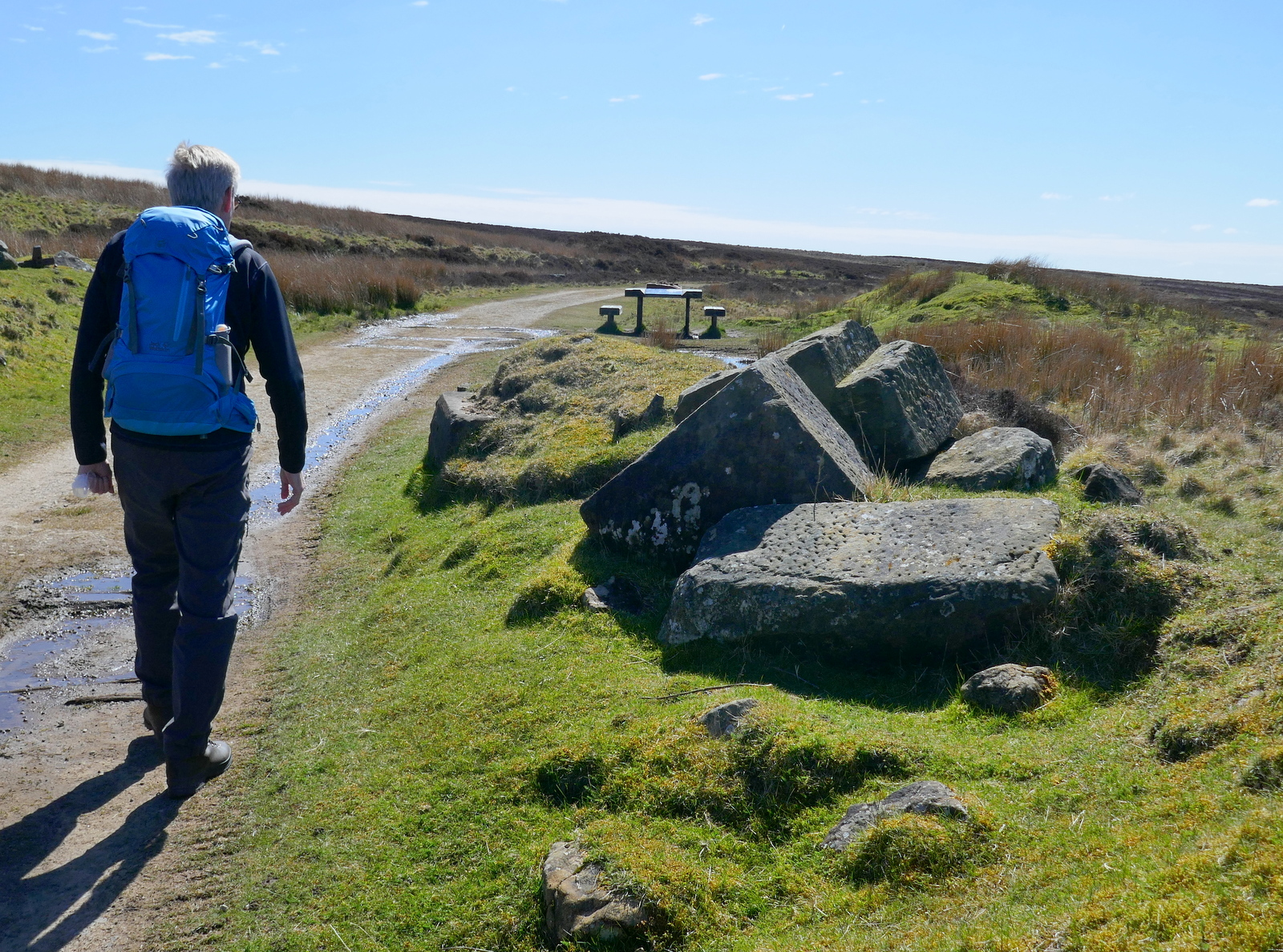
As we walked this trail we came to two old boundary posts, the first known as The Face Stone is mentioned in a 1642 document for the Helmsley Estate, and the second showing a carved hand near to Round Hill dates from 1711. Near the Hand Stone is the trig point at Botton Head which is located on a Bronze Age burial mound at 1490 feet, the highest point on the North York Moors. We walked over to examine it but there is not a very good view from here, even if it is the highest spot.
 |
| The Face Stone |
 |
| The Hand Stone |
 |
| Botton Head |
 |
| View from Trig Point |
We walked back to the wide path and to continue walking across Urra Moor, which according to TSB derives from the Old English 'horh' meaning 'filth'. Eventually we came to a new signpost where we left the Cleveland Way to bear right on an indistinct path which drops off the moor down Jackson's Bank and into Greenhow Plantation.
 |
| Cringle Moor in the distance |
 |
| Turn off at the new sign |
 |
| The Incline railway track appears ahead |
 |
| The top end of Greenhow Botton is now devoid of trees |
 |
| "I can see your house from here." |
 |
| Clive on Jackson's Bank |
We reached the bottom of Jackson's Bank at the curiously named Clogger's Hall, on the OS map - nothing to be seen, and crossed Greenhow Botton to walk towards New Sheepfold Farm.
Over to the right we could see the incline railway while ahead of us Roseberry Topping appeared in the distance. A mile or so on and several farms further, the tarmac lane took us to Low Farm.
 |
| Approaching New Sheepfold Farm |
 |
| Unusual Soay Sheep |
The path then turns left just before the farm buildings of Low Farm, into fields that we crossed one after another, at first following a newly fenced path, but later the indistinguishable rights of way by aiming for the yellow right of way signs on each field boundary.
 |
| Blossom at Low Farm |
 |
| Alongside Ingleby Plantation |
 |
| St Andrews, Ingleby Greenhow |
TSB says that the original church was granted to the abbots of Whitby in 1143 by Adam de Ingelby and still retains traces of Norman work. Some photos of the church interior
can be seen here in this blog from 2016.
A short drive took us to Great Ayton where we sat in the sun to enjoy a pint and a chat about today's enjoyable walk.
 |
| To Cloggers Hall! |