"There must be dales in Paradise
Which you and I will find.."
Showing posts with label Bilsdale "Clay Bank" "Hasty Bank" "Chop Gate" "Chisel Hill". Show all posts

Saturday 28 May 2016


Hasty Bank, Cold Moor and Upper Bilsdale


 8 miles                         Fine and still


We parked at the top of Clay Bank and crossed the road to climb Hasty Bank, but instead of following the Cleveland Way to the top, we branched left on a small track that wound its way upwards to reach the Old Quarry, shown on the map below.


Today's walk from The Walker's Guide to the Cleveland Hills

The reason for this diversion was that we wanted to pay our respects to 'The Lady of Bilsdale', described by Tom Scott Burns  as 'the enigmatic face of a lady carved on a rock wall who gazes eternally down into Bilsdale'. This ancient stone face was carved into the side of the Old Quarry, perhaps by one of the workers.  The track led us around Hasty Bank and we came to the quarry on our right and walked over to admire the Lady and share her view of Bilsdale.


Looking back to Clay Bank as we climb Hasty Bank

We take a small track climbing to the left...

... which leads us to Old Quarry

... and The Lady of Bilsdale

The Lady's view of Bilsdale and Clive

Old Quarry
Leaving the Lady we walked across the moor top to reach The Wainstones, where we picked our way carefully through the rocks before descending into Garfitts Gap and climbing onto Cold Moor.   TSB says that the name Wainstones is believed to derive from the Saxon 'wanian' - to howl, and that the naming of the stones means 'stones of lamentation'.  Fortunately there was no wind to howl through them in today's still weather


Swathes of bluebells in the fields below

We follow the track through bilberry bushes...

... to reach The Wainstones

The Wainstones

TSB mentions his favourite graffitti found on The Wainstones is 'RO WOOING TD 1712' but we have yet to come across it.


The Wainstones from Garfitts Gap


Lambs on Cold Moor

We walked along the summit of Cold Moor (1318') for 2.5 miles with a fine view as far as the Pennines over to the west and Roseberry Topping and Easby Moor to the east.  Eventually we took a clear fork to the left, taking us gently down to the village of Chop Gate.  This track is known as Cold Moor Lane and we passed through a gate where our path became a hollow lane.  TSB says that it is possible that this passageway was established by prehistoric man and has continued in use throughout history to the present day.


Approaching the summit of Cold Moor

Looking down at Seave Green, the red pan tile roof of Bilsdale Hall at 9 o'clock

Leaving Cold Moor


Cold Moor Lane

The ancient hollow lane to Chop Gate

The usually muddy path was quite passable after the recent dry spell and we were delighted to find it full of wild flowers.  We soon reached Chop Gate where we emerged at the old Wesleyan Chapel which is almost hidden between houses. The reason for the strange location of the chapel is that the landowner, Lord Feversham, was C of E and totally against a non-conformist church being established in the dale.  However a local shop keeper sold the Methodists this plot of land and the chapel was built in 1858.  TSB reports that it contains an interesting harmonium (pump organ) but its doors were firmly locked today and a 'For Sale' notice indicates that sadly there is going to be a change of use for the building.


Weather vane at Chop Gate

The rear of the chapel

The front of the chapel

War memorial at Chop Gate


TSB says that the name Chop Gate is thought to be derived from the old Scandinavian term kaup meaning pedlar and with a number of pannier tracks converging on the village it must have been like a market place in times gone by.

We turned left into the B1257 and walked along to Seave Green whose name is thought to derive from its owner in 1301, Nicholas del Seves.  Here we crossed the road to the tarmac track to Bilsdale Hall.   On the left we passed Chisel Hill Mill which ceased operation in 1930 and later became a recording studio that was used by Chris Rea in the 1980s. The studio's name became the subject of one of his songs, Chisel Hill, which some people mistakenly think refers to Roseberry Topping.   

Continuing along the lane we came to Bilsdale Hall where a moss covered wall opposite the hall provided a soft seat for our coffee stop.  As we broke open the scones an alsatian dog made its way towards us from the hall, getting ever nearer until it finally stopped and stared.  We promised it that its good behaviour would be rewarded with a biscuit when we left.


Chisel Hill

A pas de loup

We went through a gate next to the hall at a footpath sign and followed the alternative dotted path on the map above, steeply uphill, to reach Urra Moor. After pausing to admire the view and regain our breath we turned left and followed the ridge, with a succession of sweeping views of Bilsdale below us.  As well as being on the ridge of the moor we also noticed we were walking alongside the remains of an earthworks.  This earthworks stretches for 2.5 miles and its origin is forgotten, perhaps defensive, or it may have been an animal enclosure. It was known as Cliff Dyke and a couple of centuries ago as Cromwell's Lines.


Walking towards Urra Moor


Fine displays of bluebells


Climbing to Urra Moor

Looking back to Bilsdale Hall and Seave Green

The moor gate and the earthworks beyond

An old stone storage shed

Looking down from the earthworks

TSB mentions two witches who inhabited Bilsdale's moors, Peg Humphreys and her companion Alice Wood, who was said to take the form of a cat or hare. 

We followed the earthworks and eventually came to a little valley where we crossed a stream known as Maiden Spring, at 1300'.


Hasty Bank from the earthworks


Maiden Spring

Descending to cross Maiden Spring

Leaving the beck we continued to follow the earthworks until we rejoined the Cleveland Way track on Carr Ridge.  We turned left and walked steeply down to Haggs Gate where we rejoined the main road for a few yards taking us back to Clay Bank Car Park and our car.


Jackdaw Crags to the right and the crags of Hasty Bank opposite


A beady eye watches us pass

About to descend to Haggs Gate

A very short drive took us to The Buck at Chop Gate where we enjoyed a pint in the beer garden and discussed the day's walk.


Thursday 26 February 2015


Hasty Bank, Cold Moor and Upper Bilsdale


8 miles                     Wet at first, then cool and dry


We parked at Clay Bank Car Park and walked straight to the top of Hasty Bank via the Cleveland Way footpath.  


Today's walk from The Walker's Guide to the Cleveland Hills

Setting off up Hasty Bank


Tom Scott Burns suggests making a slight detour once the summit of Hasty Bank is reached, in order to find the enigmatic face of a lady carved on a rock wall who gazes eternally down into Bilsdale.   We took his suggestion as the last time we walked here my camera was on the wrong setting and my photos were spoiled.


Looking back down Hasty Bank

The lady and I gaze enigmatically down into Bilsdale

The Lady's view into Bilsdale

Leaving the Lady to her view we walked across the moor top to the Wainstones where we picked our way carefully through the slippery rocks before descending into Garfitts Gap and then climbing onto Cold Moor.   TSB says that the name Wainstones is believed to derive from the Saxon 'wanian' - to howl, and that the naming of the stones means 'stones of lamentation'. 

Approaching the Wainstones

On Cold Moor

On reaching the top of Cold Moor we turned left off the Cleveland Way and followed the track across the moor top for 2 miles, passing by a large cairn which marks the site of five burial mounds.    Further along our track we noticed a couple of wire traps set on pieces of wood.   One of them was on top of a stone wall and on examining the trap we saw it had been sprung and contained the remains of an unfortunate creature, probably a stoat, which had obviously been there for some time.  We hoped it met its end quickly and painlessly.

Trap

... and victim


We followed the track down from the moor until it became a hollow lane.  Unfortunately these hollow lanes are bridle-paths and so horses and bikes have right of access, and this one had been turned into a quagmire.  Stepping carefully through the mud we dropped down to reach the village of Chop Gate, our path joining the road near to an old Wesleyan chapel, almost hidden from the road.  The strange location is because the landowner, Lord Feversham, was C of E and totally against a non-conformist church being established in the dale.  However a local shop keeper sold the Methodists this plot of land and the chapel was built in 1858.  Apparently it contains an interesting harmonium (pump organ) but its doors were firmly locked today.


Entering the hollow lane

Hollow Lane to Chop Gate

Methodist Chapel

Wesleyan Chapel, Chop Gate

We turned left and followed the road through Chop Gate until we reached Seave Green, whose name is thought to derive from its owner in 1301, Nicholas del Seves.  We crossed the road and followed the tarmac track to Bilsdale Hall, admiring huge numbers of snowdrops along the verge as we walked.  On the left we passed Chisel Hill Mill which ceased operation in 1930 but became a recording studio that was used by Chris Rea in the 1980s, and is the subject of one of his songs, Chisel Hill.   Just past the Hall we found a sheltered spot that looked down into Stonehouse Cote and enjoyed our coffee and scones while watching a trio of sparrow hawks quartering the land below us. They were oblivious to us and making a terrific mewing noise, perhaps pairing up for the nesting season.


Seave Green

Chisel Hill Mill

Bilsdale Hall
View from our coffee stop


We then had a steep climb to the top of Urra Moor where we made a sharp left and followed the ridge, with sweeping views of Bilsdale below us.  As well as being the ridge of the moor we also noticed we were walking alongside the remains of an earthworks.  This earthworks stretches for 2.5 miles and its origin is forgotten, possibly defensive or it may have been an animal enclosure.  The ground became increasingly wet as we approached and crossed a beck below Maiden Spring.  


Looking back down to Seave Green

An old store house just under the moor top

Moor gate

Walking along Urra Moor towards Clay Bank


Crossing Maiden Spring

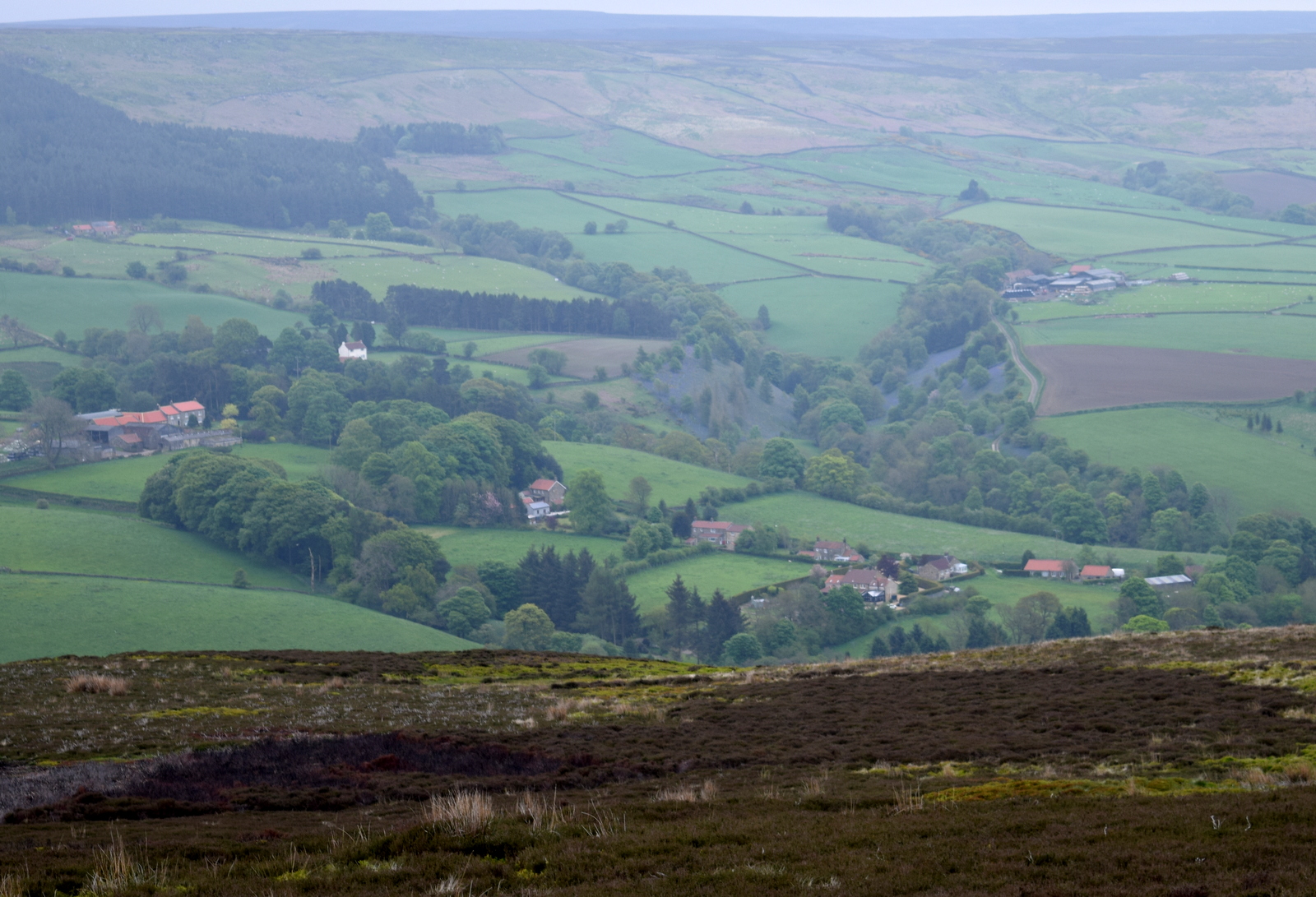
Looking down into Bilsdale from Urra Moor

Spring plumage!

Leaving Urra Moor, Roseberry in the distance


Leaving the beck we continued to follow the earthworks until we rejoined the Cleveland Way track on Carr Ridge.  We turned left and walked steeply down to Haggs Gate where we rejoined the main road for a few yards taking us back to Clay Bank Car Park and our car.


Dropping down to Clay Bank Car Park

More spring plumage!