"There must be dales in Paradise
Which you and I will find.."

Wednesday 19 February 2014


Exploring Scugdale from Carlton Bank


7 miles                                       Fair, little wind


We parked in the Lords Stones Cafe car park and crossed back over the road to walk uphill on the old gliding club roadway.


Map of today's route from The Walker's Guide to the Cleveland Hills

Looking back towards the Lords Stones and Roseberry Topping from Gliding Club roadway

On reaching the top of the moor we turned left onto a footpath which leaves the roadway.  Until last year the view to the right was spoilt by the old Gliding Club but now no trace remains of the buildings and the moor stretches out on all sides.  The first feature of note is Stone Ruck to the left of our track, a pile of large rocks which looked very spooky in the mist the last time we walked here. Shortly afterwards we arrived at Brian's Pond to the right of the track.  In summer Clive and I have seen large numbers of dragonflies hovering here.


Carlton Moor

Stone Ruck

Brians Pond

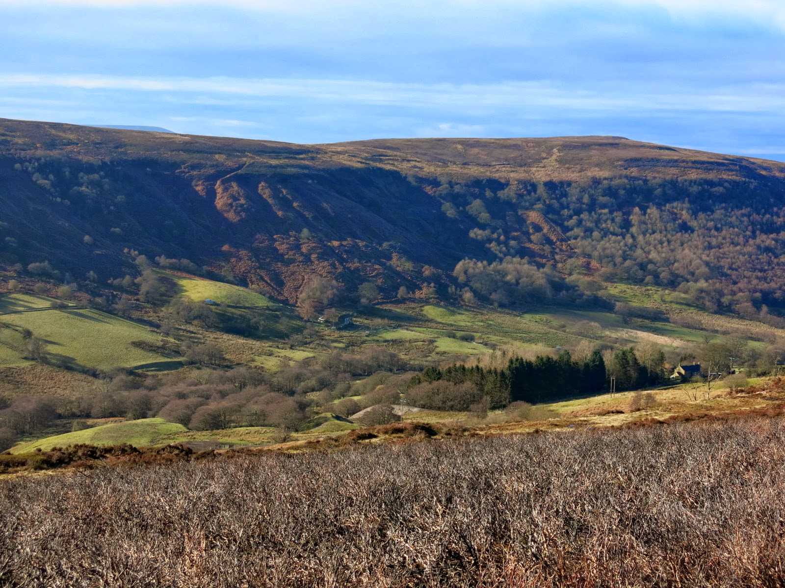
From Brians Pond our route climbed steadily over Clough Gill Top to the moor rim where we suddenly had a fine view of Scugdale below us.  Tom Scott Burns tells us that Scugdale comes from the Danish 'skygger' meaning 'to overshadow'; so Scugdale would have meant 'the sheltered dale'.   We have walked this route several times but today's fine weather gave us our best views of the dale.  Our trail eventually led us to the rugged cliffs of Barker's Crags from where we looked down into Scugdale.


Clough Gill Top

Surprise view into Scugdale

The edge of Barker's Crags


We descended from Barker's Crags to the dale road and turned left to walk up to the head of the valley and High House.    This is an old farmhouse where TSB tells us lived a certain Harry Cooper who was reputed to be the tallest man in the world, standing at 8'6".  He joined Barnum's Circus in America and died in 1898 at the age of 41.  The farm was very quiet today with no sign of life as we walked past and turned right over a field stile and down the hillside to cross Scugdale Beck.   The slopes on the opposite side of the dale showed their mine workings in relief as the sun shone on them.  Alum and jet were mined here as well as iron ore.


Dale road through Scugdale

Jet mine workings show clearly on the hillside

High House

Outbuildings at High House

Looking down Scugdale from High House

When we arrived at the beck we found that storms had washed debris down the beck completely marooning the bridge which sat uselessly amongst a pile of silt and stones which had diverted the beck.  Fortunately it was passable without the bridge.


Walking downhill to Scugdale Beck

The bridge is no longer over water!

In need of a clean-out

Our route now followed the other side of the valley, crossing fields below the old alum workings.  There was no path and we picked our way through the boggy grass, occasionally seeing a yellow waymark.  This route is obviously little walked.  Just before we arrived at Holiday House, another old farm building, we stopped in a sheltered spot and enjoyed our coffee and scones in the sun while looking across at Scugdale Hall and Barker's Crags above it. 


Scugdale Hall from our coffee stop

Barker's Crags

Setting off again we were sorry to see that Holiday House appeared deserted and in poor repair.  The last time we walked here there were pet goats, sheep and fancy hens and a flag flew cheerfully above it.  Today there were no animals to be seen and disrepair everywhere we turned.  We wondered what could have happened. Leaving the farm we walked along the path to rejoin the dale road before turning right at a green metal footpath sign at Fog Close Farm.


Holiday House Farm

Fog Close Farm

After passing the farm buildings we made our way left, following yellow way-marks, steeply uphill onto Live Moor.  As we walked along the ridge we looked down into the little known valley of Snotterdale, where there is no road or path access.  

Looking down into Snotterdale, Scugdale in the distance

Climbing to Live Moor

Walking along Live Moor

Opposite a conifer plantation our path turned left across Carlton Moor where we eventually joined the Coast to Coast walk for the last few hundred yards to the trig point at 1338 feet.  From here we looked down on the steep stone path to Lords Stones and our car.


The old Gliding Club runway

Whorlton Hill from Carlton Moor

Trig Point above Carlton Bank


Friday 14 February 2014

 Abandoned Walk

Drove to Hawnby intending to walk via Coombe Hill but standing water on paths and fields made the walk impossible.  Returned to Lords Stone and walked on to tops in bitter wind before abandoning and returning to Lords Stone for a pot of tea and a bacon sandwich.

Walking up to Falconer's Seat

Clive at Falconer's Seat

Thursday 6 February 2014


The Rosedale Railway and Botton Head from Ingleby Greenhow


8.5 miles                                       Cool,  wet underfoot


We parked in Ingleby Greenhow in the overflow car park for the Dudley Arms and walked back to the main road, in the direction of Kildale.  Our route turned right off the road into a narrow path between houses which soon exited onto a very muddy path across fields.


Today's walk from The Walker's Guide to the Cleveland Hills

Leaving the main road

Difficult paths

Field paths to Bank Foot

Our path took us across waterlogged fields via rights of way that seemed little used, until we reached Bank Foot where we turned right onto the old railway track.  Tom Scott Burns tells us that the old railway was completed in 1861 and leads to the foot of the incline bank where the trains were loaded with ironstone.  The incline reaches a maximum gradient of 1 in 5 and a brake drum house is situated at the top.  Three empty wagons were hauled by steel ropes as three loaded wagons descended, an operation which took 3 minutes at a speed of 20mph, regulated by the drum house.    Today we decided to leave the old railway track after a couple of hundred yards because we wanted to find a seat mentioned by TSB and marked on the above map as Lady Mary Ross Seat.  We climbed steeply up through the Battersby Plantation until we came to an old forestry track running parallel to the railway track.  Unfortunately water was draining from the woods onto the mud track and it was a quagmire.   We staggered along, slipping and sliding until we came upon Lady Ross's Seat, a crude stone chair engraved with the words 'Lady Mary Ross 1837'.  Little is known about her other than that she was married to the Earl of Kildale and had a daughter who married Sir William Foulis of Ingleby Manor.  The seat is believed to have been constructed here as it was the route of one of Lady Mary's favourite walks.  We were pleased to have found the seat and it made our muddy detour worthwhile.


We saw more of these crow totems - do they really work?

Clive examines Lady Mary's seat

Lady Mary Ross 1837
Forestry track adjacent to the seat


We had gained some height and were reluctant to make our way back to the old railway track so we continued along the forestry track, at one point my boot going deeply into a boggy bit, leaving me with a wet foot for the rest of the walk.  After approximately 2.5 miles the muddy track joined the old railway incline about a quarter of the way up and we turned onto a firmer surface for the steep climb uphill.  We were deeply in conversation as we climbed and unfortunately forgot to photograph the old carving of a man wearing a stove pipe hat with a bird in front of his face, believed to be graffiti dating back to the building of the railway.  It's situated where the incline cuts through a rock face about two thirds of the way up the incline. 

Picture taken last year

When we finally reached the top of the incline we were ready for coffee and scones and sat with our backs to the side of the incline, sheltered from the wind and looking back down the path we had climbed.

Climbing the incline

Looking back from our coffee stop

From bank top looking over at quarry workings

The line was officially closed on 13th June 1929 and now makes a nice 11 mile path to Farndale, Westerdale and Rosedale.    We continued to follow the railway track until we reached a turn to the right, where we saw the familiar acorn of the Coast to Coast Walk which we joined for a while.  This wide fire break track led us gently upwards to Round Hill where two ancient boundary standing stones are located, one with an engraving of a face and the other showing a hand.  We turned off the track at the Hand Stone to walk to the bronze age burial mound and its Ordnance Survey trig point, the highest spot on the North York Moors at 1490 feet.

Walking towards Botton Head


The Face Stone
Hand stone

Trig Point on Burial Mound

Ordnance Survey Trig Point at Botton Head


We walked back to the wide path and continued walking across Urra Moor, which according to TSB derives from the Old English 'horh' meaning 'filth'!  Eventually we came to a signpost and an indistinct path right which we followed to quickly drop off the moor down Jacksons Bank and into Greenhow Plantation.  


Urra Moor, Clay Bank and Wainstones in the distance

Dropping down from Urra Moor

Jacksons Bank

Once we left the moor track we were once again walking through mud and we were glad when we reached the lane down Greenhow Bottoms.   Over to the right we could see the incline railway and ahead of us Roseberry Topping appeared in the distance.  When we reached Low Farm we turned right, following a footpath sign, into Low Farm where we were amused by a small stone circle, an ancient monument - not!  Our path turned left before the farm buildings into fields which we crossed, one after another, on an unseen right of way, aiming for the yellow right of way signs at the field boundaries.  The fields were completely saturated and we squelched across them leaving deep footprints. 

Greenhow Bottoms

'Stone Circle' and incline path top left

Not a well used path

We were pleased when our path reached a bridge over Ingleby Beck and we saw the old church of St Andrews behind it.  We looked round the outside of the church but decided that our boots were too bad to enter the building, although it was unlocked.  The church was built in 1143 and rebuilt in 1741 at the parishioners' expense. 

Waterlogged fields


The bridge to St Andrews Church

We were interested to see a gravestone to the Chief Constable of Tynemouth, Tom Blackburn, who had held office between 1920 and 1946, obviously not promoted from the ranks.  What had brought him to Ingleby Greenhow, we wondered. 

St Andrews Church, Ingleby Greenhow

Tom Blackburn, Chief Constable of Tynemouth

A short walk back uphill returned us to the overflow car park and our car.