Hawnby Hill and Hazel Head from Hawnby
7 miles Sunny and breezy
Today's walk from Hawnby is one of our favourite Tom Scott Burns' walks and as it is nearly a year since we last walked this route we decided it was time for a re-visit. We arrived at Hawnby from the B1257
Stokesley to Helmsley road via the Laskill turn off and parked at the
roadside near the Inn at Hawnby.
 |
| Today's walk from The Walker's Guide to the Hambleton Hills |
 |
| The Inn at Hawnby |
|
|
The village sits under Hawnby Hill
(298m) whose twin Easterside Hill can be seen over towards the B1257. These two hills, known as Corallian Outliers, once formed
part of the Tabular Hills and have a very distinctive shape. We left the road opposite the Inn and
immediately started to climb across a field, fighting through high bracken until
we reached the top of Hawnby Hill. From here there is a good view in all
directions, to the left down to Arden Hall and to the right, Easterside
Hill. It was pleasant to identify places we had visited on previous walks as we strolled along the ridge of Hawnby Hill.
 |
| Beginning the climb from Hawnby village |
 |
| We soon enter dense bracken |
 |
| Into trees for a short while... |
 |
| ... before climbing to the ridge of Hawnby Hill |
 |
| Looking back towards Hawnby |
 |
| Looking east towards Easterside Hill |
 |
| A pleasant ridge walk |
 |
| Cairn on Hawnby Hill at 978' |
As we walked along the ridge we came to a neatly built cairn, so neat in fact that Clive and I suspect it to be the work of one person. We passed it by and coming to the end of the ridge we descended to the moor gate and the purple heather of Hawnby Moor.
 |
| Dropping down towards the moor gate |
 |
| Sign at moor gate |
We passed through the Moor Gate and
walked along the sandy path of Sunley Slack and after about a mile came
to a fork in the road. We took the left fork and followed the path,
seemingly walking straight towards Bilsdale Mast. To our right was
Round Hill which is simply a collection of rocks and a bump in the heather. Just by this we saw a wooden post with a yellow way mark pointing left away from our track, across the moor towards Hazel Head Woods whose tree tops could just be made out on the horizon. Although the way mark pointed the way we must go there was no sign whatsoever of any track, an experience which was to be repeated several times on this walk. Obviously the area isn't being walked very much which is a real shame as it has so much variety.
 |
| Looking back from Sunley Slack at Hawnby Hill |
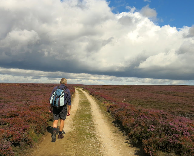 |
| Marching through the heather |
 |
| The irregular mound of Round Hill at 964' |
 |
| Deciding on the best route across the heather |
 |
| We find a track of sorts |
We dropped down from Hawnby Moor towards the trees of Hazel Head Wood. The path was very indistinct and a bit boggy but ahead of us we saw the ruins of an old building which Tom Scott Burns informs us was a Wesleyan Chapel which must have taken its congregation from the people who occupied the buildings, now ruins, that are hidden among trees in Hazel Head Wood. The chapel was a bit further on but we decided to go and have a look at it. There is nothing to report, however, except nettles, but it was in the sun and sheltered so we sat in front of it and enjoyed our coffee and scones.
 |
| Disused chapel |
 |
| We passed several large ants nests.... |
 |
| .... seething with busy ants |
 |
| Nothing but nettles but... |
 |
| ... a nice view to enjoy with our coffee |
We retraced our steps to the gate into Hazel Head Wood and found that the paths of last year were hidden in long grass. We made our way past the ruins of High Hazel Heads Farm and other ruins that pre-dated the woods, then made our way through tree stumps towards the Osmotherly to Hawnby road, which we reached just near the Hazel Heads Car Park and information board.
 |
| Gate to Hazel Head Woods |
 |
| Ruins in the woods |
 |
| What was once a way marked path leads us to the road |
 |
| A short walk along tarmac |
We turned left into the road and followed it to a stile into Ellers Wood. We walked along a wide forestry path, quickly losing height and
eventually leading us to the River Rye, where we searched for the
footbridge mentioned by TSB. We eventually found it but had to fight our way through bracken and
brambles to reach the bridge, which is obviously little used.
 |
| Leaving the road into Ellers Wood |
 |
| Saplings hide the path |
 |
| Through here to the bridge! |
 |
| The Bridge Over the River Rye |
The path through Ellers Wood is not being used and saplings and brambles are encroaching along its route; if they are not cut back the path will disappear in a couple of years.
We followed our track alongside a
beck and then into the trees of Blueberry Wood before dropping down past St
Agnes House and Half Moon Plantation. This whole area was wick with young pheasants which ran along the path in front of us. There were feeders every few yards and occasionally we saw gruesome totems where keepers had strung up dead crows to discourage unwelcome diners.
 |
| Keeper's quad but no sign of the owner |
 |
| To the left, Hawnby Hill and Easterside Hill byond |
 |
| Lazy rams at St Agnes House |
 |
| Female pheasant.. |
 |
| .. and male by a feeder |
 |
| Dead crow totem |
Passing St Agnes House farm we dropped down to a nice ford where we crossed a footbridge into Low Wood. Soon we came to the attractive arched bridge over the Rye, not mentioned by TSB as it post dates his book.
 |
| The arched bridge over the Rye appears ahead of us |
 |
| View downstream from the bridge |
A short scramble up from the bridge brought us to woodland near Carr House and we turned right to follow way marks (but no path) through several fields until we rejoined the Hawby road where we walked into the village and into the Inn at Hawnby.
 |
| Across fields from Carr House |
 |
| We regain a spring in our step |
 |
| Through a glass darkly. The view from the beer garden |
 |
| Looking across at Hawnby from the beer garden |


