"There must be dales in Paradise
Which you and I will find.."

Tuesday 7 July 2020

Sandsend to Kettleness and the Coastal Path


6.4 miles                      Warm and pleasant


This is not a TSB walk but it is a nice short walk for a summer's morning.  We drove to Sandsend and parked in the Pay and Display at the bottom of Lythe Bank.


Screenshot of today's walk, track reversed for GPS

From the car park we walked back up Lythe Bank for 300 metres then, at a bench, turned right off the road through a kissing gate at a footpath sign.  We had fine views back down to Sandsend.

'I'll watch your car, guv'.

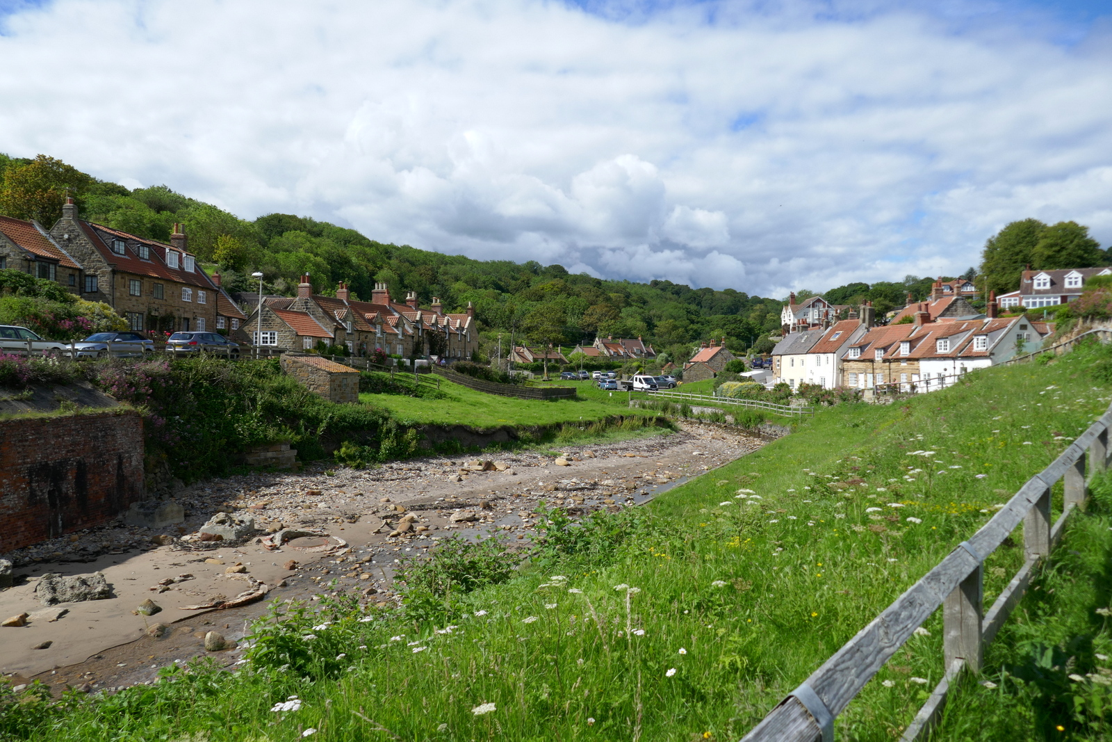
Bottom of Lythe Bank


Steep climb for 300 metres..

.. then turn right at the bench

View over to Whitby from the bench

The tracks across fields to Deepgrove Farm have not been walked and we fought our way through long grass alongside hedgerows, all the time bearing right until we reached the farm buildings.

Keep the fence to the left then cross and keep it to the right to the top of the hill

No track so choose your own way across the field

St Oswalds's at Lythe in the distance

After crossing the field the right of way is very overgrown

We keep as near to the fence as we can

I think the missing arm should point to Kettleness

Deepgrove Farm

Follow the waymarks to the right at Deepgrove Farm and quickly reach Over Dale.  Here there is a steep descent, a bridge and then a steep ascent, mostly on steps.


Into Over Dale

Steep steps

Crossing Over Dale

Follow way marks at field boundaries

After crossing Over Dale we climbed a stile into fields with Overdale Farm to our left.  We followed the farm track for about 500 metres to join a road.

We turned right on to the road and followed it into Goldsborough, where we noted the Fox and Hounds is open for business.  As we passed the last building on the right we turned into fields at a footpath sign and followed a faint grassy track down to a ruined barn and a stile.


Cross the stile and drop towards the old chapel

Kettleness ahead!

From the stile we dropped down to join the road near an old chapel, and walked down past the old station to the cliff top and the end of the road.  Here we selected a bench (there are several) with a view of Runswick Bay and enjoyed our coffee and scones.


Arriving at Kettleness
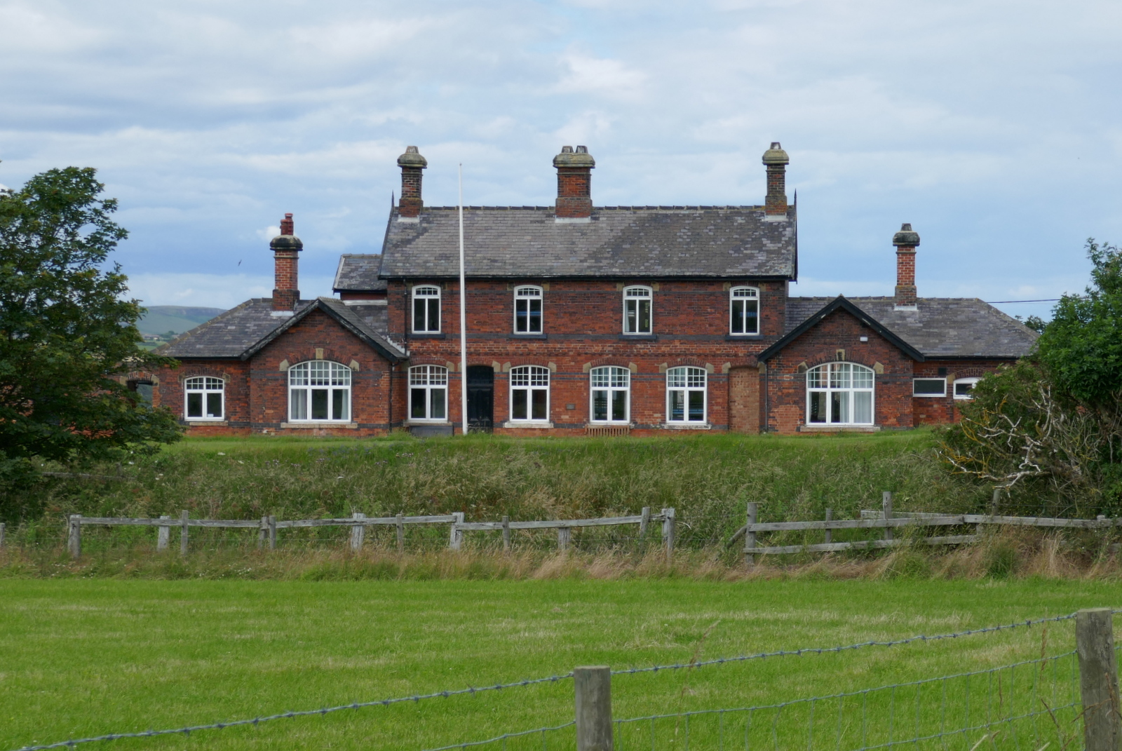
The old station...

.. and track bed at Kettleness

Nice weather vanes at Kettleness


Our view of Runswick Bay from rest stop

We set off following the Cleveland Way cliff top path all the way back to Over Dale.  The views were excellent and the path very straightforward.


Follow the Cleveland Way acorn 


The path gets very near the cliff edge in places

We are pleased to see a pedant has added the missing 'L' in Helmsley


"Back a bit more..."


We then left the cliff top and followed our path across the field to reach a stile into woods.  Here we descended into Over Dale on a very steep stepped path, to reach the old railway line. We turned left onto it and followed the gravel track for the next mile to reach Sandsend.


Into Over Dale again


Nearly down to the old railway

Follow the old railway line...

.. past Deep Grove Quarry

The railway bed makes an easy track

Heathers in flower
Picking heather


Sandsend from the old railway track


Back to the car park

Sandsend Bay

The sunny weather had brought the crowds to Sandsend so we drove to the the Fox and Hounds at Goldsborough where we toasted the walk with a pint in the beer garden.  

To short walks and long glasses!


Saturday 4 July 2020

Hazel Head to Arnsgill and Cow Ridge


Hazel Head to Arnsgill and Cow Ridge


 7 miles                       Cool and showery


We approached Hazel Head Car Park via a 7 mile drive from Osmotherley on the Hawnby road.  We passed Square Corner and after driving past the ford at Blow Gill ('ravine with the dark ford') parked our cars at Hazel Head car park, some distance uphill.


Today's walk from The Walker's Guide to the Cleveland Hills

View from Hazel Head Car Park


We walked back to Blow Gill, where we admired the waterfall and an old lime kiln at the side of the road before climbing back up the road to the entrance to Street Gate Farm.

Lime Kiln at Blow Gill

Blow Gill

Leave the road at Street Gate Farm

Tom Scott Burns explains that a number of farmers in the region had their own lime kilns for burning lime, which was used for lime washing walls and dressing the land, a custom going back to Roman times. The lime neutralises the acid in the moorland soil allowing more varied crops to be grown. 

The farm track is overgrown and very muddy.  It leads past Street Gate Farm and into South Wood.  This is an old lane and TSB tells how these lanes were used by tinkers and pedlars who became very numerous in the Middle Ages.  These travelling salesmen not only sold their goods but also played a big part in circulating news and delivering letters between settlements.

Street Gate Farm

Muddy lane

A noisy welcome at Hagg House Farm

We wondered what these were - traps?

The track leads past another farm, Hagg House, where our arrival was heralded by a deafening cacophony of barking from a pen of spaniels. 


We continued along the wet lane until we reached Birk Wood Farm where we turned right just before the building and climbed steeply to reach the Osmotherley to Hawnby road. Here we paused to examine another lime kiln, which probably once belonged to Plane Tree farm.


Tree house at Hagg House

We followed the old lane between farms

We saw a few large ants' nests at the side of the lane

Very busy!

Birkwood Farm - turn right after gate

Climb past a couple of fields

Lime kiln at Plane Tree Farm


Weather vane near Plane Tree Farm

We left the Lane at a gate opposite the Birkwood Farm entrance, to start another steep climb to reach the moor.  Passing the moor gate we walked along the edge of the moor, looking west to the grand building of Snilesworth Lodge.  Eventually the path drops from the moor to reach Arnsgill Beck which is crossed by a footbridge, just before Hill End Farm.


Easterside and Hawnby Hills in the distance

Walking along the edge of the moor


Oyster catchers


Snilesworth Lodge

Keeper's cottage

We leave the shooters' track..

.. to drop down a hollow lane

Iron fox target

Dropping down to Arns Gill

Crossing the bridge is easy, getting off it not so.

Getting from the footbridge to Hill End Farm means crossing some very wet ground and we picked our way carefully, using clumps of reeds as supports in the marshy ground. Then a steep climb took us to the side of Hill End Farm, all the time watched and barked at by the farm's spaniels, fortunately penned in.


Hill End Farm, dog pen to right

Looking back down to Arns Gill

Passing the old farm buildings

Hill End Farm's lime kiln

Hardy hill cattle


Our climb took us past the farm to the top of Arnsgill Ridge where we joined a shooters' track to pass through the moor gate and walk towards a distant plantation of conifers. 

In the past we have stopped along this ridge with its fine views to enjoy our coffee but today a brisk wind kept us moving and we followed the track until it drops down to the ruin of Head House.


Head House

Head House

Exploring the out building ruins...

... we find a sheltered spot for coffee

While we enjoyed our coffee and scones we were kept amused by a solitary lamb, which edged closer and closer to us, bleating as it did so.  It turned out to be merely curious and not a pet, as it was soon off when we approached it.

Refreshed we had a look inside the building, which is always unlocked and makes a useful shelter if caught in a storm.

We are approached

Inside Head House

New ceiling

Remains of a swallow which probably came down the chimney


They get some tough visitors here

The next room is not so tidy


Leaving Head House we dropped down to re-cross Arns Gill and then climbed to Cow Ridge.  We strode out along the moor path for a couple of miles passing fairly near to Bilsdale Mast, the top of which was lost in low cloud.


Leaving Head House 
Arns Gill


Looking back

A new trap
The rat or stoat touches the plastic in the middle and the trap snaps down from the far side


Head House and its shelter of conifers viewed from Cow Ridge

Bilsdale Mast, top in cloud

We came to a cairn which marks the location of Iron Howe.  TSB points out that all along this stretch are well preserved field boundaries, enclosures and over 300 cairns dating from 2,300 to 800 BC.  Although they don't show well in the photographs they are in fact very noticeable as you walk along this stretch of the path.


Walking along Cow Ridge

Some early heather in sheltered spots

Iron Howe

Many iron age settlement remains

After Iron Howe we descended gradually back towards Blow Gill.
On our left we spotted the old Wesleyan Chapel ruins, where we have stopped to rest on TSB's Hawnby to Hazel Head walk.  Below us we saw the unusually named Scotland Farm, and now on tarmac we dropped back to Blow Gill and our cars.


Scotland Farm

Weather vane near Scotland Farm

Blue Leicester sheep with late lambs


Ruined chapel


Looks like someone has misjudged the bend at Blow Gill