"There must be dales in Paradise
Which you and I will find.."

Friday 2 November 2018


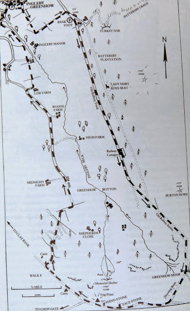
The Rosedale Railway and Botton Head from Ingleby Greenhow


 8.5 miles                                Mainly fine but cool


We parked in Ingleby Greenhow in the overflow car park for the Dudley Arms and walked back to the main road in the direction of Kildale. 

Tom Scott Burns notes in his Walker's Guide to the Cleveland Hills that the name Ingleby has been written in various ways over the years, including Angleby, Engelbi, Yngleby and Yngylby.


The route parts from the road alongside a newly built house where we followed an overgrown path onto meadows.  


Today's walk from The Walker's Guide to the Cleveland Hills


The Old Vicarage, Ingleby Greenhow


Houses in Ingleby


Turn off road at footpath sign

Track between houses leads to open fields

We crossed a field with sheep, adjacent to Ingleby Manor and then several meadows, to arrive at Bank Foot Farm situated under Turkey Nab, which is probably derived from the old personal name Thorlkil.  Tom Scott Burns says in his Walker's Guide that in 1729 William Parkin was hung from gallows mounted on Turkey Nab for murdering his brother-in-law at Great Broughton.

Fine rain is gradually clearing

Ingleby Manor

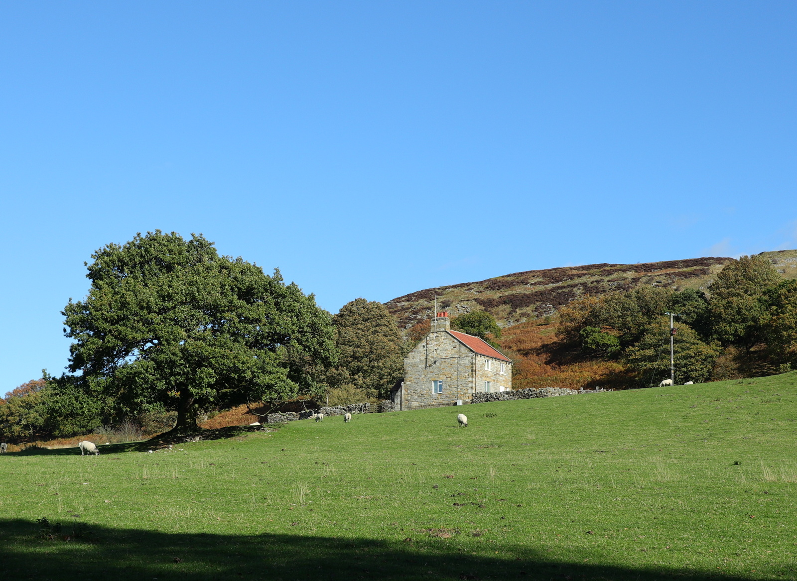
Wet horses near Bank Foot Farm


We joined the bed of the old railway track at Bank Foot and turned right to walk towards the incline bottom. After a couple of miles we passed by some old railway cottages and reached the stiff gradient of the old incline railway.  


Following the old railway track

We reach the old railway cottages

Partly hidden blacksmith weather vane at railway cottages

The left fork takes us up the Incline

A long climb!


Tom Scott Burns tells us that the old railway was completed in 1861 and leads to the foot of the incline bank where the trains were loaded with ironstone.  The incline reaches a maximum gradient of 1 in 5 and a brake drum house was situated at the top.  Three empty wagons were hauled by steel ropes as three loaded wagons descended, an operation which took 3 minutes at a speed of 20mph, regulated by the drum house.    

Just over half way up, after passing through a gate, we came to some old graffiti of a man in a top hat and a bird carved onto a rock on our left.  TSB reckons this was probably the work of a railway navvy whiling away a few minutes of leisure.

It's quite a long hard climb and as we reached the top we decided to get behind a hillock to sit and enjoy our coffee and scones out of the wind.

Looking back down the Incline

A navvy's graffiti?

Looking over to our right at old excavations

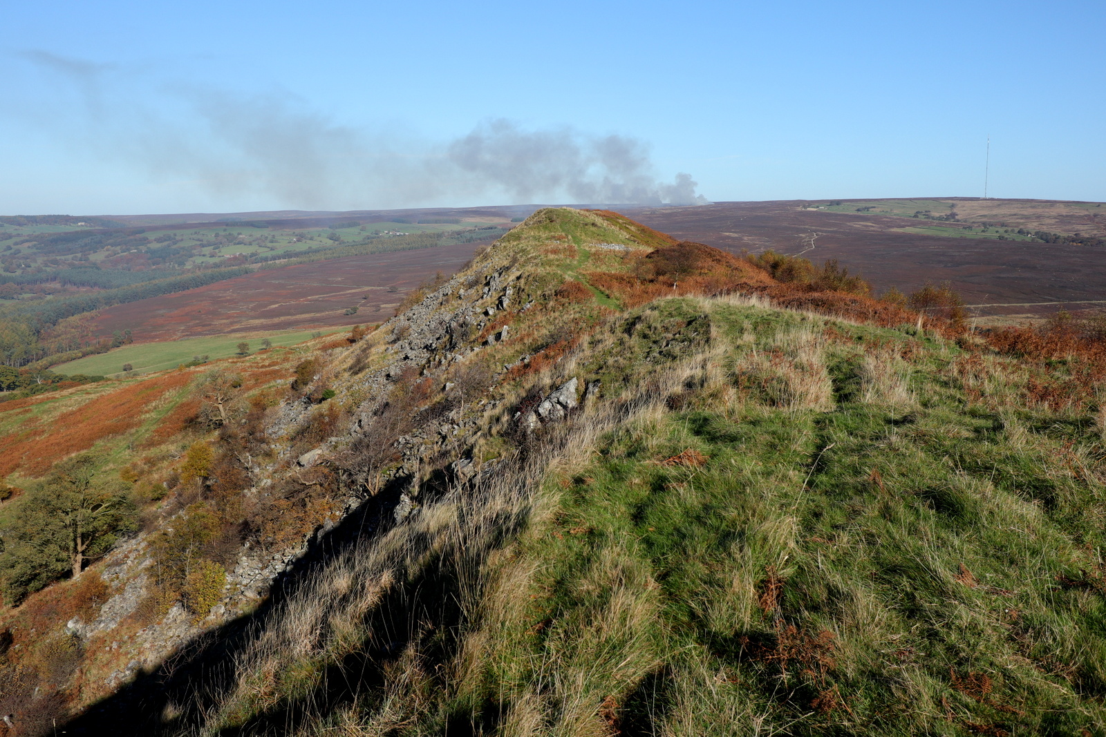
Clay Bank in the distance

A sheltered spot for coffee


Finishing our coffee we set off for the short climb to the top where we looked at the remains of the drum house.


We then continued to follow the old railway line passing a memorial bench looking down into Greenhow Botton.  This would have been an ideal spot for coffee but for the cold wind.

TSB tells us that the railway officially closed on 13th June 1929 and its flat even surface makes a nice 11 mile path to Farndale, Westerdale and Rosedale.  

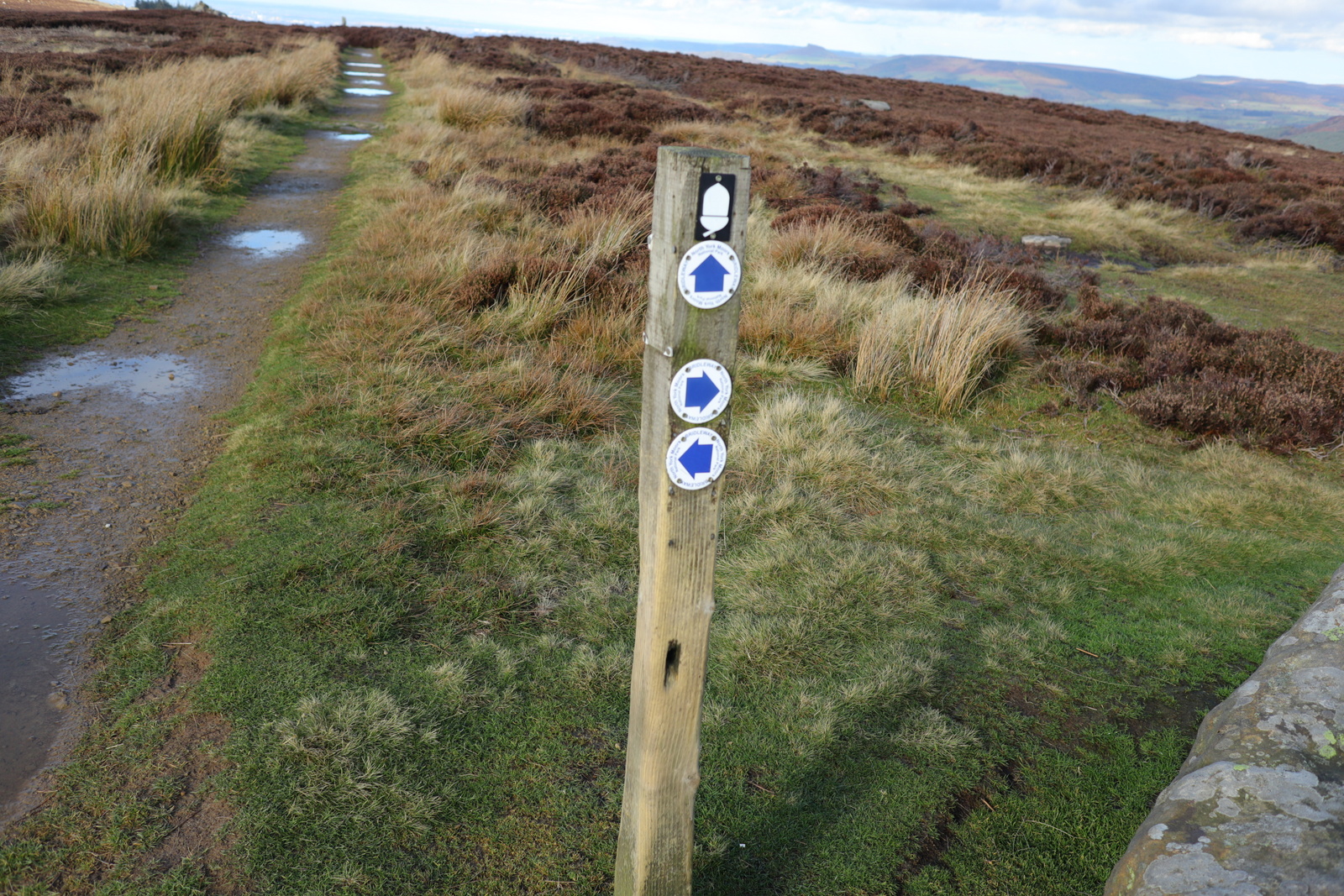
Soon after the bench we turned right off the old railway and joined a trail to Cockayne Head and Botton Head, which is part of the Cleveland Way.

As we followed this sandy path we were amused to have the company of three birds which we believe to be snow buntings.  They remained a few yards ahead of us for over a mile, never letting me near enough to get a good photo of them.


A large frog hopped across the path as we approached the old drum house

Remains of the drum house

Memorial bench

Bear right to leave the old railway

.... and join the Cleveland Way

Now following the trail to Botton Head

Grouse have their white winter gaiters on

We think these are snow buntings?

They hopped along, always a few feet ahead

White underneath and an orange patch behind the eye

As we walked this trail we came to two old boundary posts, the first known as The Face Stone is mentioned in a 1642 document for the Helmsley Estate, and the second, showing a carved hand, near to Round Hill dates from 1711.  Near the Hand Stone is the trig point at Botton Howe which is located on a Bronze Age burial mound at 1490 feet, the highest point on the North York Moors.

The Face Stone

The Hand Stone

Trig Point at Botton Howe

Our buntings finally leave us

If we are correct in our identification of the snow buntings, and I think the above photo shows its markings more clearly, then we have shared the company of a rare bird in the UK, where there are believed to be only 60 breeding pairs.  However, in the autumn they are more frequently seen in the North East of England when continental birds join our birds for the winter.
https://www.rspb.org.uk/birds-and-wildlife/wildlife-guides/bird-a-z/snow-bunting


We followed the wide path and continued across Urra Moor, which according to TSB derives from the Old English 'horh' meaning 'filth'!   

Eventually we came to a signpost and an indistinct path right that we followed to quickly drop off the moor down Jackson's Bank and into Greenhow Plantation. 

Urra Moor

Turn right at the sign onto a narrow path

Clay Bank and Wainstones over to the left

Our outward path up the Incline can be seen opposite

Descending Jackson's Bank

Approaching Greenhow Plantation

We reached the lane down Greenhow Bottoms and over to the right we could see the incline railway while ahead of us Roseberry Topping appeared in the distance.  A mile or so further on the tarmac lane and we reached Low Farm where we stopped to admire some Texel rams, one of whom appeared to have a leg injury probably caused by one of his rivals.

The Incline Railway

Texel rams

Handsome is as handsome does...

We turned right, following a footpath sign into Low Farm where we admired their 'ancient' stone circle and weather vane.

Low Farm

'Ancient' stone circle

Weather vane at Low Farm

Our path turned left before the farm buildings into fields which we crossed, one after another, on an unseen right of way, aiming for the yellow right of way signs at the field boundaries.


Across fields after Low Farm


Ram with covering paint

After a mile of field walking the path veers right into bushes and descends on a slippery paved trod to reach the bridge over Ingleby Beck, and next to the bridge, the old church of St Andrews. 

Armistice Day preparations were taking place at the church and the old building had a fine display of poppies.


Slippery trod


Crossing Ingleby Beck


St Andrew's Church


Armistice Day decorations 


A fine display


Altar Window


A good walk with a bit of everything; hills, moors, farms and woods.  Much recommended and a short drive from the Royal Oak at Ayton, where we discussed the day's finer points.


Friday 19 October 2018


Hawnby Hill and Hazel Head from Hawnby


7 miles                    Sunny and cool


This walk combines the best of moorland, woods, pasture and villages.  It's quite good underfoot and not too difficult, but as there are a couple of good climbs, not too easy.


We arrived at Hawnby from the B1257 Stokesley to Helmsley road via the Laskill turn off and parked at the roadside near the now defunct Inn at Hawnby.


Today's walk from The Walker's Guide to the Hambleton Hills


The Inn at Hawnby

The Inn at Hawnby was integral to the village of Hawnby and it is sad to think it is a pub no more.  The village seemed deserted as we walked from the car to turn off the road opposite the old Inn, and began to climb the flank of Hawnby Hill.

The village sits right under Hawnby Hill (298m) whose twin, Easterside Hill, can be seen over towards the B1257.   These two hills, known as Corallian Outliers, once formed part of the Tabular Hills and have a very distinctive shape.

Crossing a field we climbed through dying bracken to reach the top and from here there is a good view in all directions; to the left down to Arden Hall and to the right, Easterside Hill. 


Houses in Hawnby

We leave the road and walk up between the buildings

Cross a field....

... and climb through bracken.  Looking back at the village

Reaching the top

Easterside Hill to our right....

... and Arden Hall down to our left

We now had a fine ridge walk along the top of Hawnby Hill and soon reached the highest point, a cairn at 978 feet.  A new addition since our last walk is a memorial bench, just by the cairn where we sat to admire the fine view down to Arden Hall.


Approaching the cairn

New memorial bench


We walked along the ridge to the end of Hawnby Hill enjoying picking out familiar sights and walks that we could see from this vantage point, and then descended to Hawnby Moor and the moor gate at Sunley Slack.

The ridge stretched out before us

Controlled burning in the distance

A very steep descent

Looking back at Hawnby Hill from Sunley Slack

We passed the moor gate and walked along the sandy path of Sunley Slack coming to a fork in the road after about a mile.  We took the left fork and followed the path, seemingly walking straight towards Bilsdale Mast.  To our right was Round Hill which is simply a collection of rocks and a bump in the heather. 

Eventually we came to a series of direction posts on our right.  We ignored the first two and about 20 feet past the third we turned sharp left on a small track to cross the moor.


Approaching the moor gate

Looking back at Hawnby Hill and Easrterside Hill

Take the left fork

About 20' past this post turn left....

... and follow a narrow path


There is very little sign of the path indicated by Tom Scott Burns on the map above, and we made our way sometimes through heather and sometimes on sheep tracks, all the time heading towards Hazel Head Wood which we could see to our left in the distance.

Reaching the wood we walked alongside it, gradually dropping downhill until the ruined Wesleyan Chapel suddenly came into view. Alongside the wood are numerous ants' nests, some up to three feet tall.


We stopped at the chapel and sat in the sun to enjoy our coffee and scones, with a nice view over towards Bow Gill and the Osmotherley road.


Keep moving towards Hazel Head Wood

On reaching it descend through the bracken...

... until the Wesleyan Chapel comes into view.

Wesleyan Chapel

We lazed here for half an hour as it was so warm and pleasant in the sun but eventually we lumbered to our feet and resumed the walk.

We climbed back for about 100 yards to reach the gate to enter Hazel Head Woods.  We soon came to some ruined buildings.  TSB says these once belonged to High Hazel Head Farm which was last inhabited in 1946, surprisingly recent considering the state of the ruins.

We followed a grassy track through the dark wood until, bearing left, we exited the wood above Hazel Head Car Park and the Osmotherley to Hawnby road.


Entering Hazel Head Wood

Ruined buildings in the wood


Emerging from the wood...

...to cross recent logging

... and reach the Osmotherley road


From the car park we followed the road left for a short time before turning into Ellers Wood at a footpath sign.  This stretch seems unwalked and the faint path is made difficult by self-seeded saplings which obstruct what used to be the footpath.


Hidden in these saplings is a bridge that a stranger to the path might find difficult to locate, as we did the first time we walked here.  We found the bridge and crossed the River Rye.


Follow the road towards Hawnby

.. and turn off it at the footpath sign

Follow the faint path through Ellers Wood

Sometimes saplings make the going difficult

We find the bridge!

Crossing the river we joined a lane and passed through a gate into a sheep field.  We followed the river to reach a row of telegraph poles and turned left to follow them uphill to cross a stile and follow the path into conifers.

These are the trees of Blueberry Wood and we found this whole area to be full of thousands of young pheasants which ran along the path in front of us.  There were feeders every few yards.  Eventually we emerged from the conifers above St Agnes House Farm and to a surprise view of Hawnby Hill.


Crossing the River Rye


Walking alongside Eskerdale Beck towards the telegraph poles

Climbing alongside the poles

Eventually enjoying a surprise view of Hawnby Hill
Passing above St Agnes House Farm we crossed a stile and dropped down to a ford where we crossed a footbridge into Low Wood.  Soon we came to the attractive arched bridge over the Rye, not mentioned by TSB as it post dates his book, being built to replace a bridge washed away by flooding in 2005.  See here 

Texel Ram at St Agnes Farm

More rams at St Agnes Farm

A ford then a footbridge... 

... and the arched bridge appears

The Bridge Over the River Rye

From the bridge we had a short scramble up to a track leading right, coming out of the woods at the lonely Carr House.  From here we followed way marks (but no path) through several fields of sheep before eventually reaching the road just outside Hawnby.

The last time we did this walk we finished with a pint at the Inn at Hawnby but today a drive was necessary to take us to the Buck at Chop Gate for our refreshments.

Carr House

Walking through Sheep Fields...

... to reach the Hawnby road


... and a welcome pint